Mollymook Beach, New South Wales
Mollymook Beach is a suburb in the City of Shoalhaven, New South Wales, Australia. It is located about four km north of Ulladalla on the northern end of Mollymook beach on the shore of the Tasman Sea.[2][3] At the 2016 census, it had a population of 2,447.[1] It is a mostly residential area incorporating Bannister Headland and is located north of Mollymook, with the eastern part of the border formed by Blackwater Creek. The southern part of the beach lies in Mollymook.
| Mollymook Beach New South Wales | |||||||||||||||
|---|---|---|---|---|---|---|---|---|---|---|---|---|---|---|---|
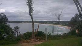 Looking south over Mollymook beach from Bannister Headland | |||||||||||||||
Mollymook Beach Location in New South Wales | |||||||||||||||
| Coordinates | 35°19′26″S 150°28′26″E | ||||||||||||||
| Population | 2,447 (2016 census)[1] | ||||||||||||||
| Postcode(s) | 2539 | ||||||||||||||
| Location | 5 km (3 mi) N of Ulladalla | ||||||||||||||
| LGA(s) | City of Shoalhaven | ||||||||||||||
| Region | South Coast | ||||||||||||||
| County | St Vincent | ||||||||||||||
| Parish | Ulladalla | ||||||||||||||
| State electorate(s) | South Coast | ||||||||||||||
| Federal Division(s) | Gilmore | ||||||||||||||
| |||||||||||||||
References
- Australian Bureau of Statistics (27 June 2017). "Mollymook Beach". 2016 Census QuickStats. Retrieved 1 February 2018.

- "Mollymook Beach". Geographical Names Register (GNR) of NSW. Geographical Names Board of New South Wales. Retrieved 1 February 2018.
- "Mollymook Beach". OpenStreetMap. Retrieved 1 February 2018.
This article is issued from Wikipedia. The text is licensed under Creative Commons - Attribution - Sharealike. Additional terms may apply for the media files.