Novorossiysk
Novorossiysk (Russian: Новоросси́йск, IPA: [nəvərɐˈsʲijsk], Adyghe: ЦӀэмэз) is a city in Krasnodar Krai, Russia. It is the country's main port on the Black Sea and the leading Russian port for exporting grain. It is one of the few cities honored with the title of the Hero City. Population: 241,952 (2010 Census);[3] 232,079 (2002 Census);[8] 185,938 (1989 Census).[9]
Novorossiysk Новороссийск | |
|---|---|
City[1] | |
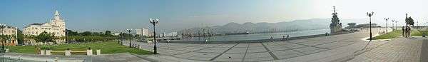
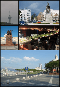 Clockwise from the top: Novorossiysk TV Tower, Freedom Square, City Harbor, Shore Promenade, Turkish War Monument | |
 Flag _(2006).png) Coat of arms | |
Location of Novorossiysk 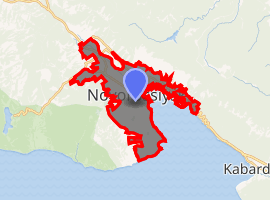
| |
 Novorossiysk Location of Novorossiysk .svg.png) Novorossiysk Novorossiysk (Krasnodar Krai) | |
| Coordinates: 44°43′N 37°45′E | |
| Country | Russia |
| Federal subject | Krasnodar Krai[1] |
| Founded | 1838 |
| Government | |
| • Mayor | Igor Dyachenko |
| Area | |
| • Total | 81.1 km2 (31.3 sq mi) |
| Elevation | 10 m (30 ft) |
| Population | |
| • Total | 241,952 |
| • Estimate (2018)[4] | 273,278 (+12.9%) |
| • Rank | 76th in 2010 |
| • Density | 3,000/km2 (7,700/sq mi) |
| • Subordinated to | City of Novorossiysk[1] |
| • Capital of | City of Novorossiysk[1] |
| • Urban okrug | Novorossiysk Urban Okrug[5] |
| • Capital of | Novorossiysk Urban Okrug[5] |
| Time zone | UTC+3 (MSK |
| Postal code(s)[7] | 353900–353903, 353905–353907, 353909–353913, 353915–353925, 353960, 353999 |
| Dialing code(s) | +7 8617 |
| OKTMO ID | 03720000001 |
| City Day | September 12 |
| Twin towns | Valparaíso, Constanța, Gainesville, Plymouth, Livorno, Gijón, Pula, Brest |
| Website | admnvrsk |
History
In antiquity, the shores of the Tsemes Bay were the site of Bata (Greek: Μπάτα), an ancient Greek colony that specialized in the grain trade. It is mentioned in the works of Strabo and Ptolemy, among others.
Following brief periods of Roman and Khazar control, from the 9th century onwards, the area was part of the Byzantine θέμα Χερσῶνος Thema Khersonos (Province of Cherson).
During the 11th century, the area was overrun and controlled by nomads from the Eurasian steppe, led by the Cumans. Later that century, the Byzantine emperor Ἀλέξιος Κομνηνός Alexios I Komnenos (r. 1081–1118) was approached by Anglo-Saxon refugees, who had left England following the Norman conquest. Alexios offered land to these refugees in Thema Khersonos if they could recapture it from the nomads and there is contemporaneous evidence that a Byzantine-English colony was subsequently founded. For example, medieval nautical charts mention place names on the Kuban coast with possible English origins, including a port (located within or near the future site of Novorossiysk) known as Susaco (or Susacho) – a name that may have been derived from Sussex.[10] (The same maps also show, north-west of Susaco, a river Londia, which may derive its name from London.[10])
In the 15th century, Genoese merchants from the Ghisolfi family maintained a trade outpost in the area. Archaeological investigation of related sites is in its infancy, but some interesting items have already been uncovered.
From 1722, the bay was controlled by an Ottoman fortress (qale) named Sujuk (also transliterated Sudzhuk, Sudschuk and Soğucak). This name may be derived from Susaco (see above) and, as late as 1769, the area was sometimes named in European maps as Suzako.
The coastline was ceded to Russia in 1829 as a result of the Russo-Turkish War. After this, admirals Mikhail Lazarev and Nikolay Raevsky founded an eastern base for the Black Sea Fleet on the shore in 1838. Named after the province of Novorossiya, the port formed a vital link in the chain of forts known as the Black Sea Coastal Line, which stretched south to Sochi.
During the rest of the 19th century, Novorossiysk developed rapidly. It was granted city status in 1866 and became the capital of the Black Sea Governorate, the smallest in the Russian Empire, in 1896. In December 1905, the city was the seat of the short-lived Novorossiysk Republic. From August 26, 1918 until March 27, 1920, Novorossiysk was the principal center of Denikin's White Army. Denikin's South Russian Government was moved to Crimea and many Whites escaped from Novorossiysk to Constantinople during the Evacuation of Novorossiysk (1920).
Most of the town was occupied by the German and Romanian Armies on September 10, 1942.[11] A small unit of Soviet sailors defended one part of the town, known as Malaya Zemlya, for 225 days beginning on February 4, 1943, and the town was liberated by the Red Army on September 16, 1943. The heroic defense of the port by the sailors allowed the Soviets to retain possession of the city's bay, which prevented the Axis from using the port for supply shipments. Novorossiysk was awarded the title Hero City in 1973.
In 1960, the town was commemorated in Dmitri Shostakovich's work Novorossiysk Chimes, the Flame of Eternal Glory (Opus 111b).
In 2003, President Vladimir Putin signed a decree setting up a naval base for the Black Sea Fleet in Novorossiysk. Russia has allocated 12.3 billion rubles (about $480 million) for the construction of the new base between 2007 and 2012. The construction of other facilities and infrastructure at the base, including units for coastal troops, aviation and logistics, will continue beyond 2012.[12] In 2016 the naval base remained incomplete; completion is currently scheduled for 2020.[13][14]
The Russian lease on port facilities in Sevastopol, which, though the main base of Russia's Black Sea Fleet, is part of Ukraine, was set to expire in 2017.[15] Ukraine was reported to be planning to not renew the lease; however, in April 2010 the Russian and Ukrainian presidents signed an agreement to extend the lease by twenty-five years, with an option of further extension of five years after the new term expires.[16] However, in 2014, Crimea was annexed by the Russian Federation during the 2014 Crimean crisis and as such the question of renewing the lease does not immediately arise while Crimea remains de facto part of the territory of the Russian Federation.
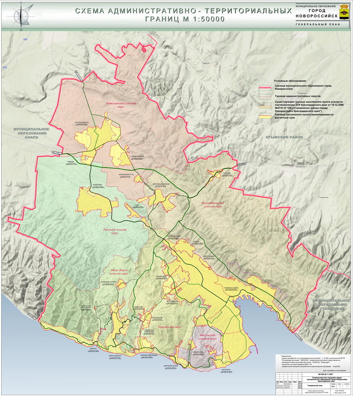
Administrative and municipal status
Within the framework of administrative divisions, it is, together with twenty-four rural localities, incorporated as the City of Novorossiysk—an administrative unit with the status equal to that of the districts.[1] As a municipal division, the City of Novorossiysk is incorporated as Novorossiysk Urban Okrug.[5]
Climate
Novorossiysk has a hot-summer mediterranean climate (Köppen climate classification Csa).
| Climate data for Novorossiysk (1936-1987) | |||||||||||||
|---|---|---|---|---|---|---|---|---|---|---|---|---|---|
| Month | Jan | Feb | Mar | Apr | May | Jun | Jul | Aug | Sep | Oct | Nov | Dec | Year |
| Record high °C (°F) | 22.8 (73.0) |
21.0 (69.8) |
25.0 (77.0) |
28.0 (82.4) |
31.8 (89.2) |
38.0 (100.4) |
39.0 (102.2) |
36.1 (97.0) |
34.0 (93.2) |
30.0 (86.0) |
28.0 (82.4) |
25.0 (77.0) |
39.0 (102.2) |
| Average high °C (°F) | 6.1 (43.0) |
6.5 (43.7) |
9.7 (49.5) |
15.0 (59.0) |
19.6 (67.3) |
24.1 (75.4) |
27.6 (81.7) |
27.7 (81.9) |
23.1 (73.6) |
17.2 (63.0) |
12.7 (54.9) |
8.8 (47.8) |
16.5 (61.7) |
| Daily mean °C (°F) | 2.9 (37.2) |
3.6 (38.5) |
6.3 (43.3) |
11.5 (52.7) |
16.2 (61.2) |
20.5 (68.9) |
23.8 (74.8) |
23.5 (74.3) |
18.9 (66.0) |
13.4 (56.1) |
9.4 (48.9) |
5.9 (42.6) |
13.0 (55.4) |
| Average low °C (°F) | −0.2 (31.6) |
0.5 (32.9) |
3.1 (37.6) |
8.2 (46.8) |
12.9 (55.2) |
16.9 (62.4) |
20.0 (68.0) |
19.7 (67.5) |
15.1 (59.2) |
9.8 (49.6) |
6.2 (43.2) |
2.8 (37.0) |
9.5 (49.1) |
| Record low °C (°F) | −18.0 (−0.4) |
−17.0 (1.4) |
−12.2 (10.0) |
−5.0 (23.0) |
−1.1 (30.0) |
2.0 (35.6) |
8.0 (46.4) |
10.0 (50.0) |
4.7 (40.5) |
−2.0 (28.4) |
−6.1 (21.0) |
−13.0 (8.6) |
−18.0 (−0.4) |
| Average precipitation mm (inches) | 125.6 (4.94) |
76.6 (3.02) |
104.7 (4.12) |
58.6 (2.31) |
41.5 (1.63) |
49.9 (1.96) |
38.5 (1.52) |
50.9 (2.00) |
35.9 (1.41) |
61.0 (2.40) |
61.4 (2.42) |
156.2 (6.15) |
860.2 (33.87) |
| Average precipitation days | 8.6 | 6.9 | 6.8 | 6.3 | 5.3 | 5.0 | 3.6 | 3.2 | 3.6 | 5.0 | 6.1 | 9.4 | 69.8 |
| Source: climatebase.ru[17] | |||||||||||||
Economy
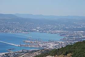
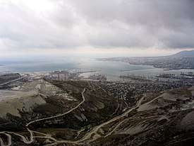
The city sprawls along the shore of the non-freezing Tsemess Bay, which has been recognized since antiquity as one of the superior bays of the Black Sea.
The Novorossiysk Commercial Sea Port–with the market capitalization of $1,110,000,000 and shares listed at Moscow Exchange and London Stock Exchange–serves Russian sea trade with regions of Asia, Middle East, Africa] Mediterranean, and South America. It is the busiest oil port in the Black Sea and the terminus of the pipeline from the Tengiz Field, developed by the Caspian Pipeline Consortium.
Novorossiysk is also an industrial city, dependent on steel, food processing, and the production of metal goods and other manufactures. Extensive limestone quarries supply important cement factories in and around the city. The town is home to the Maritime State Academy and Novorossiysk Polytechnic Institute.
Transportation
Novorossiysk is connected by rail and highways to the main industrial and population centres of Russia, Transcaucasia, and Central Asia. The public transportation within the city boundaries consists of city buses, trolleybuses, and marshrutkas (routed taxis). However, with time, more and more people rely on automobiles as primary means of transportation.
The closest airports (Gelendzhik Airport, Anapa Airport and Krasnodar Airport, situated 33 kilometres (21 mi), 53 kilometres (33 mi) and 172 kilometres (107 mi) away from the city, respectively, offers flights to many cities in Russia.
Sports
The city association football team, FC Chernomorets Novorossiysk, plays in the Russian second Division.
Environment
Novorossiysk is not a resort town, but Anapa to the north and Gelendzhik to the south are. There are several urban settlements under the jurisdiction of Novorossiysk. The most famous is Abrau-Dyurso, which consists of a townlet on the shore of Lake Abrau and a village on the coast of the Black Sea, connected by a winding mountain road.
The area of Novorossiysk is one of Russia's main wine-growing regions. The wineries of Abrau-Dyurso, established by Tsar Alexander III in 1870, produce table and sparkling wines for domestic consumption.
Buildings and structures

- Novorossiysk TV Tower
- Shopping Mall "Krasnaya Ploshchad"
- "Lenin's" Amusement Park
- Malaya Zemlya Memorial
Notable residents
- Seitumer Emin (1921 – 2004), Crimean Tatar writer and civil rights activist
- Ida Nudel (born 1931), refusenik and Israeli activist
- Eugene Kaspersky (born 1956), founder of Kaspersky Labs
Twin towns and sister cities
Novorossiysk is twinned with:[18]
|
References
Notes
- Reference Information #34.01-707/13-03
- Генеральный план городского округа муниципального образования город Новороссийск Краснодарского края. Схема административно-территориальных границ.
- Russian Federal State Statistics Service (2011). "Всероссийская перепись населения 2010 года. Том 1" [2010 All-Russian Population Census, vol. 1]. Всероссийская перепись населения 2010 года [2010 All-Russia Population Census] (in Russian). Federal State Statistics Service.
- "26. Численность постоянного населения Российской Федерации по муниципальным образованиям на 1 января 2018 года". Federal State Statistics Service. Retrieved January 23, 2019.
- Law #686-KZ
- "Об исчислении времени". Официальный интернет-портал правовой информации (in Russian). June 3, 2011. Retrieved January 19, 2019.
- Почта России. Информационно-вычислительный центр ОАСУ РПО. (Russian Post). Поиск объектов почтовой связи (Postal Objects Search) (in Russian)
- Russian Federal State Statistics Service (May 21, 2004). "Численность населения России, субъектов Российской Федерации в составе федеральных округов, районов, городских поселений, сельских населённых пунктов – районных центров и сельских населённых пунктов с населением 3 тысячи и более человек" [Population of Russia, Its Federal Districts, Federal Subjects, Districts, Urban Localities, Rural Localities—Administrative Centers, and Rural Localities with Population of Over 3,000] (XLS). Всероссийская перепись населения 2002 года [All-Russia Population Census of 2002] (in Russian).
- "Всесоюзная перепись населения 1989 г. Численность наличного населения союзных и автономных республик, автономных областей и округов, краёв, областей, районов, городских поселений и сёл-райцентров" [All Union Population Census of 1989: Present Population of Union and Autonomous Republics, Autonomous Oblasts and Okrugs, Krais, Oblasts, Districts, Urban Settlements, and Villages Serving as District Administrative Centers]. Всесоюзная перепись населения 1989 года [All-Union Population Census of 1989] (in Russian). Институт демографии Национального исследовательского университета: Высшая школа экономики [Institute of Demography at the National Research University: Higher School of Economics]. 1989 – via Demoscope Weekly.
- Green, Caitlin (May 19, 2015). "The medieval 'New England': a forgotten Anglo-Saxon colony on the north-eastern Black Sea coast". Retrieved February 25, 2018.
- Robert Forczyk, The Caucasus 1942–43: Kleist’s race for oil
- http://rusnavy.com/news/navy/index.php?ELEMENT_ID=16492
- Putin orders vast expansion of Russia's Black Sea Fleet
- "Russia to Finish Construction of Novorossiysk Naval Base by 2020". Sputnik News. July 28, 2016. Retrieved January 4, 2019.
- Michael J. Strauss (January 9, 2009). "And when the lease on Sevastopol expires?". International Herald Tribune. Retrieved January 9, 2009.
- The Great Power (mis)Management by Alexander Astrov, Ashgate Publishing, 2011, ISBN 1409424677 (page 82)
- "Novorossijsk Climate Data". Climatebase. Retrieved November 6, 2017.
- Международные Связи - Администрация муниципального образования город-герой Новороссийск (in Russian). Archived from the original on December 23, 2011. Retrieved December 21, 2011.
- "Plymouth - Town Twinning". Plymouth City Council. Retrieved July 14, 2013.
- "Međunarodna suradnja Grada Pule". Grad Pula (in Croatian and Italian). Archived from the original on May 5, 2012. Retrieved July 28, 2013.
Sources
- Управление по взаимодействию с органами местного самоуправления Администрации Краснодарского края. Справочная информация №34.01-707/13-03 от 23 мая 2013 г. «Реестр административно-территориальных единиц Краснодарского края». (Department of Cooperation with the Organs of the Local Self-Government of the Administration of Krasnodar Krai. Reference Information #34.01-707/13-03 of May 23, 2013 Registry of the Administrative-Territorial Units of Krasnodar Krai. ).
- Законодательное Собрание Краснодарского края. Закон №686-КЗ от 1 апреля 2004 г. «Об установлении границ муниципального образования город Новороссийск и наделении его статусом городского округа», в ред. Закона №1756-КЗ от 3 июня 2009 г «О внесении изменений в некоторые законодательные акты Краснодарского края об установлении границ муниципальных образований». Вступил в силу со дня официального опубликования. Опубликован: "Кубанские новости", №64–65, 17 апреля 2004 г. (Legislative Assembly of Krasnodar Krai. Law #686-KZ of April 1, 2004 On Establishing the Borders of the Municipal Formation of the City of Novorossiysk and on Granting It Urban Okrug Status, as amended by the Law #1756-KZ of June 3, 2009 On Amending Various Legislative Acts of Krasnodar Krai on Establishing the Borders of the Municipal Formations. Effective as of the day of the official publication.).
External links
- Official website of Novorossiysk (in Russian)
- Novorossiysk commercial sea port
- Informational portal of city (in Russian)
- Our Novorossiysk (in Russian)
- Site of Novorossiysk City. Map of Novorossiysk (in Russian)
- Photos of Novorossiysk (in Russian)
- Novorossiysk Police Department (in Russian)
- Soviet topographic map 1:100,000
Hero Cities of the Soviet Union | ||
|---|---|---|
| Authority control |
|
|---|