Gavar
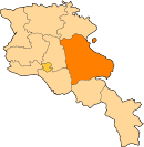
Gavar (Armenian: Գավառ), is a town and urban municipal community in Armenia serving as the administrative centre of Gegharkunik Province. It is situated among the high mountains of Gegham range to the west of Lake Sevan, with an average height of 1982 meters above sea level. Located 98 kilometers east of the capital Yerevan, the town had a population of 20,765 as per the 2011 census. As per the 2016 official estimate, the population of Gavar is 19,500.[2]
Gavar Գավառ Kyavar (Քյավառ) | |
|---|---|
 Gavar | |
 Seal | |
 Gavar | |
| Coordinates: 40°21′32″N 45°07′36″E | |
| Country | |
| Marz | Gegharkunik |
| Founded City status | 1830 1850 |
| Area | |
| • Total | 16 km2 (6 sq mi) |
| Elevation | 1,982 m (6,503 ft) |
| Population (2011 census) | |
| • Total | 20,765 |
| • Density | 1,300/km2 (3,400/sq mi) |
| Time zone | UTC+4 (AMT) |
| Postal code | 1201-1205 |
| Area code(s) | (+374) 264 |
| Vehicle registration | 02 |
| Website | Official website |
| Sources: Population[1] | |
Gavar is the seat of the Diocese of Gegharkounik of the Armenian Apostolic Church.
Etymology
The town was known as Nor Bayezet or Novo-Bayazet until 1959, named after the Western Armenian town of Bayazet (historically known as Daroynk and Arshakavan). Between 1959 and 1995, the town was known as Kamo, named after the Bolshevik revolutionary Kamo (Simon Ter-Petrosian). On December 4, 1995, the town was renamed Gavar, meaning county in the Armenian language.
However, Gavar is colloquially known as Kyavar (Քյավառ)[3][4] since the 19th century.
History
Gavar was founded as Novo-Bayazet (New Bayazit) in 1830 around 8 km west of the Lake Sevan, by Armenian migrants from the town of Bayazit (historically known as Daroynk and Arshakavan) of the Ottoman Empire. The settlement achieved the status of a town in 1850.
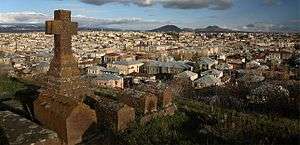
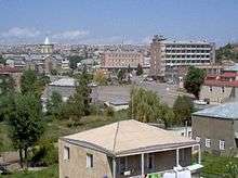
However, the area of modern-day Gavar has been inhabited since the Bronze Age. Many historical tombstones, dating back to the 2nd millennium BC are founded in Gavar. The remains of a cyclopean fort dating back to the early Iron Age, are found on a hill at the centre of the town. It is supposed that the fortress was the royal capital of the Velikukhi region within the Urartu kingdom. It was surrounded with more than 22 minor fortifications. The region of Velikukhi was conquered by the Urartian king Sarduri II. His son, Rusa II renamed the fortress in honour of Khaldi; one of the three chief deities of Ararat.[5] The Artsvakar neighbourhood of Gavar is also home to another Iron Age fortress, dating back to the 2nd millennium BC.
.jpg)
After the establishment of the ancient Kingdom of Armenia, the territory of modern-day Gavar was included within the Gegharkunik canton at the north of the historic Syunik province of Armenia Major.
Many other medieval monuments, including monasteries, Khachkars (cross-stones), gravestones and a chapel are also found in the town. The Hatsarat neighbourhood (a separate village until the 1960s) is home to the Hatsarat Monastery with 2 churches dating back to the 7th and 19th centuries.[6]
Over the centuries, the area of modern-day Gavar had been severely destroyed, with the latest taking place during the 17th century, when it was ruined by Shah Abbas I of Persia.
In 1828, after the Russo-Persian War, the region of Gegharkunin — as a part of the Erivan Khanate — was handed over to the Russian Empire as a result of the Treaty of Turkmenchay signed on 21 February 1828. In 1830, the Armenian migrants from Bayazit founded the village of Novo-Bayazet. With the establishment of the Erivan Governorate in 1850, Novo-Bayazet became the centre of the newly formed Novobayazetsky Uyezd.
Novo-Bayazet, along with many other regions of Eastern Armenia became part of the USSR in December 1920. After achieving the status of an urban-type settlement in 1950, the town has gradually grown over the years. In 1959, the town was known as Kamo, named after the Bolshevik revolutionary Kamo. It was once home to 36,400 people at the beginning of the 1980s.[7]
After the independence of Armenia in, the town was renamed Gavar in 1995 and became the provincial centre of the newly established Gegharkunik Province. However, much of the Soviet-era infrastructure of the town has failed and the industrial capacity has floundered. As a result, the population of Gavar has drastically declined to 23,302 as reported in the 2001 census, and later to 20,765 as reported in the 2011 census.
Geography and climate

At an average height of 1982 meters above sea level, Gavar is situated on the shores of Gavaraget river. The town is dominated by the Gegham mountains from the west and the Lake Sevan from the east. At a height of 3,597 meters, mount Azhdahak is located around 15 km southwest of Gavar.
The town is surrounded by a number of villages including Noratus from the east, Karmirgyugh and Gandzak from the south.
Climate
Gavar features a humid continental (Köppen Dfb) climate, which is characterized by cold winters and warm summers. The annual precipitation level is 450 mm.
| Climate data for Gavar 1961 m asl (1981–2010 normals) | |||||||||||||
|---|---|---|---|---|---|---|---|---|---|---|---|---|---|
| Month | Jan | Feb | Mar | Apr | May | Jun | Jul | Aug | Sep | Oct | Nov | Dec | Year |
| Record high °C (°F) | 10.6 (51.1) |
11.9 (53.4) |
18.5 (65.3) |
25.1 (77.2) |
27.6 (81.7) |
30.5 (86.9) |
32.7 (90.9) |
34.1 (93.4) |
30.1 (86.2) |
24.5 (76.1) |
20.6 (69.1) |
12.7 (54.9) |
34.1 (93.4) |
| Average high °C (°F) | −0.6 (30.9) |
−0.3 (31.5) |
3.4 (38.1) |
10.7 (51.3) |
15.4 (59.7) |
19.7 (67.5) |
22.8 (73.0) |
23.1 (73.6) |
20.3 (68.5) |
14.0 (57.2) |
7.0 (44.6) |
1.3 (34.3) |
11.4 (52.5) |
| Daily mean °C (°F) | −6.3 (20.7) |
−6.1 (21.0) |
−1.8 (28.8) |
5.3 (41.5) |
9.5 (49.1) |
13.2 (55.8) |
16.3 (61.3) |
16.4 (61.5) |
12.7 (54.9) |
7.5 (45.5) |
1.5 (34.7) |
−4.0 (24.8) |
5.4 (41.6) |
| Average low °C (°F) | −11.9 (10.6) |
−11.9 (10.6) |
−7.0 (19.4) |
−0.2 (31.6) |
3.5 (38.3) |
6.6 (43.9) |
9.7 (49.5) |
9.7 (49.5) |
5.1 (41.2) |
1.0 (33.8) |
−4.1 (24.6) |
−9.4 (15.1) |
−0.7 (30.7) |
| Record low °C (°F) | −33 (−27) |
−32.7 (−26.9) |
−30.9 (−23.6) |
−22.2 (−8.0) |
−15.2 (4.6) |
−4.8 (23.4) |
−3.1 (26.4) |
−2.2 (28.0) |
−5.8 (21.6) |
−21.2 (−6.2) |
−27.2 (−17.0) |
−27.6 (−17.7) |
−33 (−27) |
| Average precipitation mm (inches) | 17.1 (0.67) |
24.7 (0.97) |
40.2 (1.58) |
52.3 (2.06) |
69.3 (2.73) |
79.4 (3.13) |
61.1 (2.41) |
49.0 (1.93) |
23.5 (0.93) |
35.0 (1.38) |
31.1 (1.22) |
19.8 (0.78) |
502.5 (19.79) |
| Average precipitation days (≥ 1 mm) | 4.29 | 5.84 | 8.42 | 9.94 | 13.26 | 11.35 | 8.39 | 7.43 | 4.61 | 7.43 | 5.29 | 4.83 | 91.08 |
| Source 1: Météo climat stats[8] | |||||||||||||
| Source 2: Météo Climat [9] | |||||||||||||
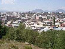
Demographics
.jpg)
The vast majority of the population in Gavar are ethnic Armenians whose ancestors migrated from the town of Doğubeyazıt during the 1820s and 1830s.
Gavar used to have a population of more than 30,000 during the Soviet years. However, it has gradually declined after the independence of Armenia.
Here is the population timeline of Gavar since 1831:
| Year | 1831 | 1897 | 1926 | 1939 | 1959 | 1974 | 1989 | 2001 | 2011 | 2016 |
|---|---|---|---|---|---|---|---|---|---|---|
| Population | 1,346 | 8,486 | 8,447 | 8,277 | 8,751 | 21,382 | 31,234 | 26,621 | 20,765 | 19,500 |
Religion
.jpg)
The people of Gavar are mainly Christians and belong to the Armenian Apostolic Church. The town has many medieval chapels and churches. The Surp Karapet Church of 1848 is among the well-preserved churches in Gavar. The Cathedral of the Holy Mother of God in Gavar is the seat of the Diocese of Gegharkunik of the Armenian Church. It was built in 1905 at the central square of the town, with the efforts of then-bishop Khoren Muradbegian with help of the local citizens. Until the late 1990s, it was the highest church in Armenia in terms of altitudes.
The town is also home to many other churches including:
- Hatsarat Monastery with the churches of the Holy Mother of God (7th century) and Saint Gregory the Illuminator (19th century).
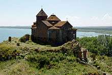
- Hayravank Monastery of the 9th century: located 7 kilometers north of Gavar on the shores of Lake Sevan.
- Surp Khach (Holly Cross) chapel of the 17th century, renovated in 1969.
- Surp Karapet Church built by Barsegh Artsruni in 1848 and entirely renovated in 2012.[10]
The Noratus cemetery archaeological site is located in the Noratus village just 4 kilometers east of Gavar. It is home to a large number of impressive medieval khachkars (cross-stones).
Culture
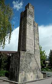
Gavar has a history museum, a cultural palace, a drama theatre, many public libraries and monument dedicated to the victims of the Great Patriotic War during World War II.
The town has an educational teaching centre (1923), school of music (1945), palace of culture (1970), school of art (1982), public library (2002), and a special school of duduk named after Gevorg Dabaghyan (2010). The municipality runs a youth creativity centre as well.
Gavar has a portal which is used by many citizens abroad. The name of the portal is Kyavar, as the locals pronounce the name of the city with a "ky" sound instead of a "g" sound at the beginning of the name.
Cuisine
The cuisine of Gavar is closely related with the oriental cuisine elements, characterized with various spices, vegetables, fish, and fruits combination.
Kyavari Kyufta (kofta of Gavar), the town's most favourite dish, is made from minced meat spiced with onions and rolled into balls before boiling in water. Served in slices, it is garnished with butter. People of Gavar like to eat bread with almost everything, and the two traditional types of bread in Gavar are lavash and matnakash.
The Kyavar baklava is a many-layered pastry with tissue-thin sheets of phyllo dough, filled with nuts and sugar and finished with a dousing of hot honey.
In June 2017, the first take away restaurant called Kyavari was opened in the centre of Yerevan, offering traditional dishes from Gavar.
Transportation
Gavar is located on the M-10 Motorway that connects the town with northeastern Armenia. The H-39 Road connects Gavar with the surrounding town and villages.
Gavar has an airstrip since the Soviet years, located to the north of the town.
Economy
After being granted the status of an urban-type settlement in 1950, the town became one of the major industrial centres of the Armenian SSR. It was home to a large electrical cable factory known as Kamokabel as well as a machines manufacturing plant.
However, after the independence of Armenia in 1991, most of the Soviet-era industry has dreadfully declined. However, the local economy is improving within slow rates as many native businessmen are returning to Gavar from Russia in the hope of finding new chances of investments.
Currently, Gavar is home to the "Gavar Furniture Factory" since 1948, the "Sevan Mineral Water Plant" founded in 1953 (reopened in 2015), the "Aquatic LLC" for processed crayfish founded in 2002, the "Kirakosyan" furniture factory founded in 2006, and the "Shushan Production Cooperative" for soft drinks.
Services
Gavar has a medical centre, a central hotel known as Khaldi, a local TV station known as Kyavar TV and many branches of local Armenian banks.
Education
Education continues to be one of the main values in the society of Gavar. A literacy rate of 99% was reported as early as 1960. Nowadays, there are nine public education schools, six nursery schools, four specialized technical intermediate colleges, one sports school, two music and art schools, one special school for children with special educational needs and one university in the town of Gavar.
The Gavar State University was opened in 1993 after the independence of Armenia. With its five faculties the Gavar University is a major educational centre for the entire province of Gegharkunik. The University provides degrees in Philology, Natural Sciences, Humanities, Economics and Education. Nowadays, more than 2,400 students are attending the university.
The Gavar Special School is the only school for mentally and physically handicapped children in the region. It is currently carrying out steps towards improvement and development with the assistance of its partners and sponsors on its way to become a leading institution among the special schools in Armenia.
Sport
Football and chess are popular in the town. The sports school of Gavar was opened in 1971 and currently provides trainings in many team and individual sports, including martial arts, basketball, futsal, boxing, weightlifting, etc.[11]
Hovhannes Goharyan from Gavar, has played as a striker for the Armenia national football team in 2009-10.
In December 2011, the renowned Armenian player Henrikh Mkhitaryan visited the town along with the president of the FFA Ruben Hayrapetyan for charity purposes.[12]
International relations
Notable people
Here are some notable people who were born or raised in the town of Gavar:
- Ivan Gevorkian (1907-1989), Soviet-Armenian surgeon and scientist
- Samvel Kocharyants (1909-1993), Soviet Armenian engineer and developer of the first Soviet nuclear warheads for ballistic missiles.[13]
- Frunze Dovlatyan (1927–1997), film director, actor and screenwriter
- Hranush Hakobyan (1954-), politician and current minister of diaspora
See also
References
- 2011 Armenia census, Gegharkunik Province
- Population estimate of Armenia as of 01.01.2016
- "Գեղարքունիքի ավանդապատումները". hzham.am. Archived from the original on 2016-03-03. Retrieved 2015-03-22.
Գավառ, որը ժողովրդի մեջ գործածական է Քյավառ ձևով
- "Գեղարքունիք [Gegharkunik]". agro.am (in Armenian).
Նախկինում բնակավայրի Գավառ անվանումը տեղացիների կողմից աղավաղվելով դարձել է Քյավառ:
- Find Armenia:Gavar Archived 2010-08-22 at the Wayback Machine
- Hatsarat, Gegharkunik
- Gavar portal:Kyavar
- "Moyennes 1981-2010 Arménie" (in French). Retrieved 11 November 2019.
- "Météo Climat stats for Gavar". Météo Climat. Retrieved 11 November 2019.
- Surp Karapet Church of Gavar
- Gavar sports school
- Henrikh Mkhitaryan and Ruben Hayrapetyan visited Gavar
- http://www.biblioatom.ru/founders/kocharyants_samvel_grigorevich/
| Wikimedia Commons has media related to Gavar. |
External links
- Gavar town council official website
- Nor Bayazet Community Development Charitable Fund of Gavar
- Gavar State University
- Kyavari Cuisine in Yerevan
- Armeniapedia.org: Gavar