Belfield, North Dakota
Belfield is a city in Stark County, North Dakota, United States. The population was 800 at the 2010 census.[5] Belfield was founded in 1883. It is part of the Dickinson Micropolitan Statistical Area.
Belfield, North Dakota | |
|---|---|
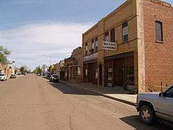 Downtown Belfield | |
| Motto(s): "Gateway To The West" "Where Friends Meet On The Custer Trail" | |
 | |
| Coordinates: 46°53′10″N 103°11′55″W | |
| Country | United States |
| State | North Dakota |
| County | Stark |
| Area | |
| • Total | 1.09 sq mi (2.82 km2) |
| • Land | 1.08 sq mi (2.80 km2) |
| • Water | 0.01 sq mi (0.03 km2) |
| Elevation | 2,585 ft (788 m) |
| Population | |
| • Total | 800 |
| • Estimate (2018)[3] | 999 |
| • Density | 730/sq mi (280/km2) |
| Time zone | UTC-7 (Mountain (MST)) |
| • Summer (DST) | UTC-6 (MDT) |
| ZIP code | 58622 |
| Area code(s) | 701 |
| FIPS code | 38-05820 |
| GNIS feature ID | 1034713[4] |
| Website | web |
Geography
Belfield is located at 46°53′10″N 103°11′55″W (46.885981, -103.198622).[6]
According to the United States Census Bureau, the city has a total area of 1.09 square miles (2.82 km2), of which, 1.08 square miles (2.80 km2) is land and 0.01 square miles (0.03 km2) is water.[1]
Demographics
| Historical population | |||
|---|---|---|---|
| Census | Pop. | %± | |
| 1920 | 526 | — | |
| 1930 | 653 | 24.1% | |
| 1940 | 870 | 33.2% | |
| 1950 | 1,051 | 20.8% | |
| 1960 | 1,064 | 1.2% | |
| 1970 | 1,130 | 6.2% | |
| 1980 | 1,274 | 12.7% | |
| 1990 | 887 | −30.4% | |
| 2000 | 866 | −2.4% | |
| 2010 | 800 | −7.6% | |
| Est. 2018 | 999 | [3] | 24.9% |
| U.S. Decennial Census[7] 2018 Estimate[8] | |||
2010 census
As of the census[2] of 2010, there were 800 people, 360 households, and 225 families residing in the city. The population density was 740.7 inhabitants per square mile (286.0/km2). There were 418 housing units at an average density of 387.0 per square mile (149.4/km2). The racial makeup of the city was 97.3% White, 0.9% Native American, 0.9% Asian, 0.6% from other races, and 0.4% from two or more races. Hispanic or Latino of any race were 1.9% of the population.
There were 360 households, of which 29.4% had children under the age of 18 living with them, 45.0% were married couples living together, 12.2% had a female householder with no husband present, 5.3% had a male householder with no wife present, and 37.5% were non-families. 32.2% of all households were made up of individuals, and 10% had someone living alone who was 65 years of age or older. The average household size was 2.22 and the average family size was 2.78.
The median age in the city was 42.4 years. 22.2% of residents were under the age of 18; 8.1% were between the ages of 18 and 24; 23.9% were from 25 to 44; 29.7% were from 45 to 64; and 16.4% were 65 years of age or older. The gender makeup of the city was 50.8% male and 49.3% female.
2000 census
As of the 2000 Census,[9] there were 866 people, 355 households, and 235 families residing in the city. The population density was 799.8 people per square mile (309.6/km2). There were 439 housing units at an average density of 405.4 per square mile (156.9/km2). The racial makeup of the city was 97.69% White, 0.23% African American, 0.23% Native American, 0.23% Asian, and 1.62% from two or more races. Hispanic or Latino of any race were 1.39% of the population. The top two ancestry groups in the city were German (57.1%) and Ukrainian (17.0%) of the population.
There were 355 households, out of which 34.1% had children under the age of 18 living with them, 52.1% were married couples living together, 9.9% had a female householder with no husband present, and 33.8% were non-families. 31.8% of all households were made up of individuals, and 14.1% had someone living alone who was 65 years of age or older. The average household size was 2.44 and the average family size was 3.09.
In the city, the population was spread out, with 27.6% under the age of 18, 6.5% from 18 to 24, 28.6% from 25 to 44, 20.6% from 45 to 64, and 16.7% who were 65 years of age or older. The median age was 38 years. For every 100 females, there were 104.2 males. For every 100 females age 18 and over, there were 95.3 males.
The median income for a household in the city was $27,619, and the median income for a family was $31,167. Males had a median income of $26,146 versus $14,609 for females. The per capita income for the city was $12,478. About 16.7% of families and 18.6% of the population were below the poverty line, including 24.5% of those under age 18 and 10.3% of those age 65 or over.
Business
Belfield is located between the junction of 2 major roadways, I-94 and U.S. Route 85. It is becoming greatly affected by the thriving oil activity in the area. The city has several businesses including the Trapper's Kettle Restaurant and Motel, The Cowboy Inn, Cenex/Superpumper, Dan's Conoco Station, The Roughrider Bar and Steakhouse, Belfield Laundromat, Loved N Hated Tattoo and several others.
References
- "US Gazetteer files 2010". United States Census Bureau. Archived from the original on 2012-01-25. Retrieved 2012-06-14.
- "U.S. Census website". United States Census Bureau. Retrieved June 14, 2012.
- "Population and Housing Unit Estimates". Retrieved June 2, 2019.
- "US Board on Geographic Names". United States Geological Survey. October 25, 2007. Retrieved January 31, 2008.
- "2010 Census Redistricting Data (Public Law 94-171) Summary File". American FactFinder. United States Census Bureau. Retrieved 2 May 2011.
- "US Gazetteer files: 2010, 2000, and 1990". United States Census Bureau. 2011-02-12. Retrieved 2011-04-23.
- United States Census Bureau. "Census of Population and Housing". Retrieved July 13, 2013.
- "Population Estimates". United States Census Bureau. Retrieved June 2, 2019.
- U.S. Census Bureau. Census 2000. "Census Demographic Profiles, Belfield, North Dakota" (PDF). CenStats Databases. Retrieved 2009-01-31.
Municipalities and communities of Stark County, North Dakota, United States | ||
|---|---|---|
| Cities | 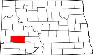 Map of North Dakota highlighting Stark County | |
| Unincorporated communities | ||
| Authority control |
|
|---|