Nes municipality
Nes is a municipality in Akershus in Viken county, Norway. It is part of the traditional region of Romerike. The administrative centre of the municipality is the village of Årnes.
Nes kommune | |
|---|---|
 Coat of arms 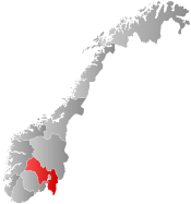 Viken within Norway | |
 Nes within Viken | |
| Coordinates: 60°7′51″N 11°29′21″E | |
| Country | Norway |
| County | Viken |
| District | Romerike |
| Administrative centre | Årnes |
| Government | |
| • Mayor (2007) | Oddmar Blekkerud (Ap) |
| Area | |
| • Total | 637 km2 (246 sq mi) |
| • Land | 609 km2 (235 sq mi) |
| Area rank | 177 in Norway |
| Population (2017) | |
| • Total | 21,513 |
| • Rank | 53 in Norway |
| • Density | 35/km2 (90/sq mi) |
| • Change (10 years) | 15.7% |
| Demonym(s) | Nesbu[1] |
| Time zone | UTC+01:00 (CET) |
| • Summer (DST) | UTC+02:00 (CEST) |
| ISO 3166 code | NO-3034 |
| Official language form | Bokmål[2] |
| Website | www |

General information
Name
The municipality (originally the parish) is named after the old Nes farm (Old Norse: Nes which means "headland"), since the first church was built here. The actual nes is the headland made by the two great rivers Glomma and Vorma, which have their meeting point just south of the farm. Prior to 1889, the name was spelled "Næs".
Coat-of-arms
The coat-of-arms is from modern times. They were granted in 1988. The arms show three yellow logs (to represent forestry) on a green background (to symbolize youth and hope). The position of the logs represents the meeting of the rivers Glomma and Vorma, creating the headland of Nes.[3]
| Ancestry | Number |
|---|---|
| 461 | |
| 257 | |
| 141 | |
| 134 | |
| 116 | |
| 115 | |
| 106 | |
| 105 | |
| 97 | |
| 85 |
History
The parish of Næs was established as a municipality of its own on 1 January 1838 (see formannskapsdistrikt).
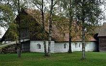
Nes Church Ruins
Nes Church ruins (Nes kirkeruin) are one of Norway's best preserved church ruins. The church which dated from ca 1100 was designed in Romanesque style and was extended into a cruciform church in 1697. The old medieval stone was located near the juncture of two rivers; Glomma and Vorma. The church suffered fire damage in 1854. After the fire the walls were preserved as ruins. The new Nes Church was completed in 1860.[5][6]
Geography
The municipality borders Eidsvoll, Ullensaker, Sørum, and Aurskog-Høland in Akershus county and Eidskog, Sør-Odal, and Nord-Odal in Hedmark county.
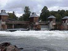
Nes includes many natural attractions, such as parts of the river Glomma, as well as 168 lakes. Elk, beaver, wolf, and lynx can be found here. Hunting and sportfishing are very prevalent.
Eight hundred farms make the area one of the largest producers of wheat in the country.
Villages
References
- "Navn på steder og personer: Innbyggjarnamn" (in Norwegian). Språkrådet.
- "Forskrift om målvedtak i kommunar og fylkeskommunar" (in Norwegian). Lovdata.no.
- "Beskrivelse av kommunevåpenet" (in Norwegian). Nes kommune. Archived from the original on 2011-06-10. Retrieved 2008-12-20.
- "Immigrants and Norwegian-born to immigrant parents, by immigration category, country background and percentages of the population". ssb.no. Retrieved 25 June 2017.
- Sigrid Marie Christie, Håkon Christie. "Nes gamle kirke". Norges Kirker. Retrieved September 1, 2016.
- "Nes Kirkeruin". Museum of Akersus. Retrieved June 1, 2017.
External links


- Municipal fact sheet from Statistics Norway

- Tourist information
- Raumnes: newspaper for Nes på Romerike (in Norwegian)
 |  | ||||||||||||||||||||||||||||||||||||||||
|