Nannestad
Nannestad is a municipality in Akershus in Viken county, Norway. It is part of the traditional region of Romerike. The administrative centre of the municipality is the village of Teigebyen. Nannestad was established as a municipality on 1 January 1838 (see formannskapsdistrikt).
Nannestad kommune | |
|---|---|
 Coat of arms 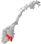 Viken within Norway | |
 Nannestad within Viken | |
| Coordinates: 60°14′44″N 10°57′10″E | |
| Country | Norway |
| County | Viken |
| District | Romerike |
| Administrative centre | Teigebyen |
| Government | |
| • Mayor (2007-) | Anne-Ragni K. Amundsen (Ap) |
| Area | |
| • Total | 341 km2 (132 sq mi) |
| • Land | 324 km2 (125 sq mi) |
| Area rank | 259 in Norway |
| Population (2012) | |
| • Total | 11,362 |
| • Rank | 102 in Norway |
| • Density | 31/km2 (80/sq mi) |
| • Change (10 years) | 23.0% |
| Demonym(s) | Nannestadsokning[1] |
| Time zone | UTC+01:00 (CET) |
| • Summer (DST) | UTC+02:00 (CEST) |
| ISO 3166 code | NO-3036 |
| Official language form | Bokmål[2] |
| Website | www |
General information
Name
The municipality (originally the parish) is named after the old Nannestad farm (Old Norse: Nannastaðir), since the first church was built here. The first element is the genitive case of Nanni (an old Norse male name) and the last element is staðir which means "homestead" or "farm".
Coat-of-arms
The coat-of-arms is from modern times. They were granted in 1990. The arms show three yellow coltsfoot flowers on a green background. This is a flower that is prevalent in the area.[3]
| Ancestry | Number |
|---|---|
| 539 | |
| 239 | |
| 179 | |
| 156 | |
| 143 | |
| 117 | |
| 61 | |
| 56 | |
| 56 | |
| 53 |
Geography
Nannestad is located in northwestern Akershus county, with inhabitants concentrated at Romerikssletta. It includes the villages of Maura, Holter and Teigebyen, the latter being the administrative centre.
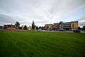 Nannestad plaza
 Nannestad high school
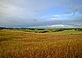 Field of Nannestad
References
- "Navn på steder og personer: Innbyggjarnamn" (in Norwegian). Språkrådet.
- "Forskrift om målvedtak i kommunar og fylkeskommunar" (in Norwegian). Lovdata.no.
- "Kommunevåpen" (in Norwegian). Retrieved 2008-12-20.
- "Immigrants and Norwegian-born to immigrant parents, by immigration category, country background and percentages of the population". ssb.no. Retrieved 25 June 2017.
External links


- Municipal fact sheet from Statistics Norway

- Municipality website (in Norwegian)
 |  | ||||||||||||||||||||||||||||||||||||||||
|