Nemërçka
Nemërçka Mountains (Albanian: Nemërçkë, Greek: Doúsko, Nemértsika or Aeropós Δούσκο, Νεμέρτσικα or Αεροπός) are a mountain range in southern Albania between Përmet and Gjirokastër District, which extends from a north-west direction to the south-east near the border between Albania and Greece. Geologically, Nemërçkë is a limestone-flysch forming a massive anticline situated between the graben valley of Vjosë river. The mountain forms the southern section of the Trëbëshinj-Dhëmbel-Nemërçka mountain chain. To the north, Nemërçkë is separated from the Albanian Pindus mountains, by the Vjosë river. The mountains are characterized by steep cliffs and wooden mountain slopes. The eastern scarps falls on the Vjosë river, 2000 metres down.
| Nemërçka | |
|---|---|
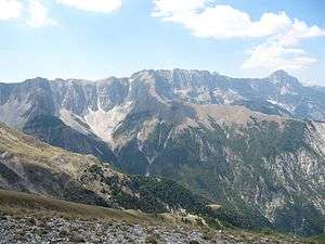 Southern Nemërçka Mountains. | |
| Highest point | |
| Elevation | 2,485 m (8,153 ft) [1][2][3] |
| Prominence | 1,792 m (5,879 ft) [4] |
| Listing | Ultra |
| Coordinates | 40°7′27″N 20°25′57″E |
| Geography | |
| Location | Gjirokastër and Përmet, Albania |
| Parent range | Trëbëshinj-Dhëmbel-Nëmerçka |
| Geology | |
| Age of rock | Triassic |
| Mountain type | Limestone |
Nemërçka falls within the Pindus Mountains mixed forests terrestrial ecoregion of the Palearctic temperate broadleaf and mixed forest. Its forests are renowned for housing European beech (Fagus sylvatica). It is the southernmost point where European beech can be found in Albania.[5]
Maja e Papingut, (formerly Albanian: Maja e Dritës), is the highest peak within the mountain range. With an elevation of 2,482 m (8,143 ft) and a prominence of 1,792 m (5,879 ft) above sea level, it is the 44th most prominent mountain peak in Europe.[6] Other peaks in Nemërçkë includes Maja e Gatakut 2,269 m (7,444 ft), Maja e Qesarit 2,253 m (7,392 ft), and Maja e Poliçanit 2,138 m (7,014 ft).
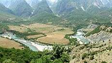 Vjosë river and Nemërçka in the background |
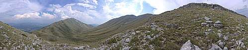 Valley between Nemërçka and Dhëmbel |
See also
| Wikimedia Commons has media related to Nemërçka. |
- Geography of Albania
- Mountains of Albania
- Southern Mountain Range
References
- "EUROPE ULTRA-PROMINENCES". peaklist.org.
- "The genus Pinguicula (Lentibulariaceae) in Albania – a critical review" (PDF). academia.edu. p. 15.
- "TREGUES SIPAS QARQEVE INDICATORS BY PREFECTURES" (PDF). Archived from the original (PDF) on 2011-07-24. Retrieved 2011-07-24.
- "The European 100 Finest Mountains ranked by primary factor". ii.uib.no.
- "dIsTrIbuTIoN oF euroPeaN beech IN aLbaNIa" (PDF). literatur.vti.bund.de (in German and English). p. 13.
- "The genus Pinguicula (Lentibulariaceae) in Albania – a critical review" (PDF). zobodat.at. p. 1.