Navigation Road station
Navigation Road is a station that serves both Northern Trains and Manchester Metrolink located in the east of Altrincham, in Greater Manchester, England. It consists of a Northern-operated heavy rail station on the Mid-Cheshire Line, and an adjoining light rail stop on the Altrincham Line of Greater Manchester's Metrolink network. The original heavy rail element of the station was opened by the Manchester, South Junction and Altrincham Railway in 1931, and the Metrolink element opened in 1992. A level crossing operates at the southern end of the station.
| Navigation Road | |
|---|---|
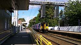 A Northern Rail train calling at the heavy rail platform | |
| Location | |
| Place | Altrincham |
| Local authority | Trafford |
| Coordinates | 53.3953°N 2.3433°W |
| Grid reference | SJ772888 |
| Operations | |
| Station code | NVR |
| Managed by | Northern Trains |
| Number of platforms | 1 |
| DfT category | F2 |
| Live arrivals/departures, station information and onward connections from National Rail Enquiries | |
| Annual rail passenger usage* | |
| 2014/15 | |
| 2015/16 | |
| 2016/17 | |
| 2017/18 | |
| 2018/19 | |
| Passenger Transport Executive | |
| PTE | Greater Manchester |
| National Rail – UK railway stations | |
| |
History
The station originally opened on 20 July 1931 on the Manchester, South Junction and Altrincham Railway (MSJAR) following the electrification of that line, and was referred to as Navigation Road (Altrincham) on early tickets, timetables, etc. British Rail electric trains between Manchester and Altrincham ceased serving the station on 24 December 1991. The former Altrincham-bound (down) platform has since been used for Mid-Cheshire Line trains and the former Manchester-bound (up) platform reopened as a Metrolink stop on 15 June 1992. Freight trains also operate through Navigation Road, including heavy block trains carrying limestone from quarries at Tunstead (near Buxton) to alkali works at Northwich.
Facilities
There is a car park on the Metrolink side of the station with 65 spaces plus 5 disabled spaces.[1]
In January 2018 a ticket machine was installed within the shelter on the heavy rail side of the station. Pre-ordered tickets can be collected here as well as buying tickets for journeys from this station.
Services
Rail
Navigation Road is served by an hourly train service between Manchester Piccadilly and Chester via Stockport and Northwich, which is run by Northern Trains, with additional trains at peak times.[2] The Sunday service originally ran only between Chester and Altrincham thus not serving Navigation Road, with passengers connecting onto the Metrolink at Altrincham for stations to Manchester, however a 2-hourly Sunday service to Manchester and beyond is now in place.
Metrolink
| Navigation Road | |||||||||||||||||||||||||||||||||||||||||||||||||||||||||||||||||||||||||||||||||||||||||||||||||||||||||||||||||||||||||||||||||||||||||||||
|---|---|---|---|---|---|---|---|---|---|---|---|---|---|---|---|---|---|---|---|---|---|---|---|---|---|---|---|---|---|---|---|---|---|---|---|---|---|---|---|---|---|---|---|---|---|---|---|---|---|---|---|---|---|---|---|---|---|---|---|---|---|---|---|---|---|---|---|---|---|---|---|---|---|---|---|---|---|---|---|---|---|---|---|---|---|---|---|---|---|---|---|---|---|---|---|---|---|---|---|---|---|---|---|---|---|---|---|---|---|---|---|---|---|---|---|---|---|---|---|---|---|---|---|---|---|---|---|---|---|---|---|---|---|---|---|---|---|---|---|---|---|
| Metrolink | |||||||||||||||||||||||||||||||||||||||||||||||||||||||||||||||||||||||||||||||||||||||||||||||||||||||||||||||||||||||||||||||||||||||||||||
 A M5000 Metrolink tram leaving Navigation Road for Altrincham | |||||||||||||||||||||||||||||||||||||||||||||||||||||||||||||||||||||||||||||||||||||||||||||||||||||||||||||||||||||||||||||||||||||||||||||
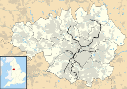 Navigation Road Location of Navigation Road in Greater Manchester | |||||||||||||||||||||||||||||||||||||||||||||||||||||||||||||||||||||||||||||||||||||||||||||||||||||||||||||||||||||||||||||||||||||||||||||
| Location | |||||||||||||||||||||||||||||||||||||||||||||||||||||||||||||||||||||||||||||||||||||||||||||||||||||||||||||||||||||||||||||||||||||||||||||
| Place | Altrincham | ||||||||||||||||||||||||||||||||||||||||||||||||||||||||||||||||||||||||||||||||||||||||||||||||||||||||||||||||||||||||||||||||||||||||||||
| Local authority | Trafford | ||||||||||||||||||||||||||||||||||||||||||||||||||||||||||||||||||||||||||||||||||||||||||||||||||||||||||||||||||||||||||||||||||||||||||||
| Coordinates | 53.39528°N 2.34333°W | ||||||||||||||||||||||||||||||||||||||||||||||||||||||||||||||||||||||||||||||||||||||||||||||||||||||||||||||||||||||||||||||||||||||||||||
| Platforms | 1 | ||||||||||||||||||||||||||||||||||||||||||||||||||||||||||||||||||||||||||||||||||||||||||||||||||||||||||||||||||||||||||||||||||||||||||||
| Fare zone information | |||||||||||||||||||||||||||||||||||||||||||||||||||||||||||||||||||||||||||||||||||||||||||||||||||||||||||||||||||||||||||||||||||||||||||||
| Metrolink Zone | 4 | ||||||||||||||||||||||||||||||||||||||||||||||||||||||||||||||||||||||||||||||||||||||||||||||||||||||||||||||||||||||||||||||||||||||||||||
| Present status | In operation | ||||||||||||||||||||||||||||||||||||||||||||||||||||||||||||||||||||||||||||||||||||||||||||||||||||||||||||||||||||||||||||||||||||||||||||
| Operations | |||||||||||||||||||||||||||||||||||||||||||||||||||||||||||||||||||||||||||||||||||||||||||||||||||||||||||||||||||||||||||||||||||||||||||||
| Original operator | Manchester, South Junction and Altrincham Railway | ||||||||||||||||||||||||||||||||||||||||||||||||||||||||||||||||||||||||||||||||||||||||||||||||||||||||||||||||||||||||||||||||||||||||||||
| Post-grouping company | Manchester, South Junction and Altrincham Railway | ||||||||||||||||||||||||||||||||||||||||||||||||||||||||||||||||||||||||||||||||||||||||||||||||||||||||||||||||||||||||||||||||||||||||||||
| History | |||||||||||||||||||||||||||||||||||||||||||||||||||||||||||||||||||||||||||||||||||||||||||||||||||||||||||||||||||||||||||||||||||||||||||||
| Opened | 20 July 1931 | ||||||||||||||||||||||||||||||||||||||||||||||||||||||||||||||||||||||||||||||||||||||||||||||||||||||||||||||||||||||||||||||||||||||||||||
| Closed as rail station | 25 December 1991 | ||||||||||||||||||||||||||||||||||||||||||||||||||||||||||||||||||||||||||||||||||||||||||||||||||||||||||||||||||||||||||||||||||||||||||||
| Conversion to Metrolink operation | 15 June 1992 | ||||||||||||||||||||||||||||||||||||||||||||||||||||||||||||||||||||||||||||||||||||||||||||||||||||||||||||||||||||||||||||||||||||||||||||
| |||||||||||||||||||||||||||||||||||||||||||||||||||||||||||||||||||||||||||||||||||||||||||||||||||||||||||||||||||||||||||||||||||||||||||||

Navigation Road is located on the Altrincham Line with trams towards Altrincham stopping every 6 minutes during the day Monday to Saturday and every 12 minutes Monday to Saturday evenings and on Sundays. In the opposite direction, trams head towards Piccadilly and Bury, with the Monday to Saturday daytime service running every 12 minutes to both Piccadilly and Bury. Evening and Sunday journeys run to Piccadilly only.[3]
As of January 2019, Navigation Road is located in Metrolink fare zone 4.[4]
Service pattern
- 10 trams per hour to Altrincham (5 off-peak)
- 5 trams per hour to Bury (peak only)
- 5 trams per hour to Piccadilly.
Bus
Navigation Road station is served by Diamond Bus routes 285, which runs anti-clockwise, and 286, which runs clockwise, both running every hour. These routes run between Altrincham Interchange and Timperley, as a circular service.[5]
References
- "Metrolink Stop Information". Retrieved 21 October 2013.
- "Northern Rail timetable 17" (PDF). Northern Rail. Retrieved 7 September 2010.
- "Metrolink - Tram Times - Navigation Road". Metrolink. Retrieved 13 February 2013.
- "Metrolink ticket zones map". TfGM. Retrieved 5 December 2018.
- "Buses: 285 286" (PDF). Transport for Greater Manchester. Retrieved 6 December 2018.
Further reading
- Mitchell, Vic; Smith, Keith (2013). Chester Northgate to Manchester. Middleton Press. figs. 86-87. ISBN 9781908174512. OCLC 892704846.
External links
| Wikimedia Commons has media related to Navigation Road station. |
- Train times and station information for Navigation Road station from National Rail
- National Rail Enquiries - Station Facilities for Navigation Road
- Metrolink Times Information and Stop Information
- Navigation Road Metrolink area map
- Picture of Navigation Road station The Trams.co.uk
- Mid-Cheshire Community Rail Partnership
| Preceding station | Following station | |||
|---|---|---|---|---|
Altrincham Terminus | Altrincham – Bury Line | towards Bury |
||
| Altrincham – Piccadilly Line | towards Piccadilly |
|||
| Altrincham | Northern Trains Mid-Cheshire Line |
Stockport | ||
| Bolton | |
|---|---|
| Bury |
|
| Manchester (Manchester station group in italics) | |
| Oldham | |
| Rochdale | |
| Salford |
|
| Stockport | |
| Tameside | |
| Trafford |
|
| Wigan | |
† stations on the East Lancashire Railway (heritage)
| |
| Tram stops |
|   | ||||||||||||||||||
|---|---|---|---|---|---|---|---|---|---|---|---|---|---|---|---|---|---|---|---|---|
| Operations |
| |||||||||||||||||||
| History (Timeline) |
| |||||||||||||||||||
| Proposed developments |
| |||||||||||||||||||
| ||||||||||||||||||||
Buildings and structures in the Metropolitan Borough of Trafford, England | ||
|---|---|---|
| Buildings |     | |
| Places of worship | ||
| Education |
| |
| Transportation | ||
| Shopping complexes | ||
| Sport and Entertainment | ||
| Bridges | ||
| Others | ||
| Demolished | ||
| Lists | ||
| Listed buildings in | ||