National Register of Historic Places listings on the island of Hawaii
This is a list of properties and districts on the island of Hawaiʻi in the U.S. state of Hawaiʻi that are listed on the National Register of Historic Places. The island is coterminous with Hawaiʻi County, the state's only county that covers exactly one island. There are 88 properties and districts on the island, including 10 historic districts, six National Historic Landmarks, and one National Historic Landmark District.

Several sites are within Hawaiʻi Volcanoes National Park, a UNESCO World Heritage Site
.svg.png)
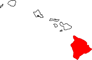
Location of the island of Hawaiʻi
Current listings
| [1] | Name on the Register | Image | Date listed[2] | Location | City or town | Description |
|---|---|---|---|---|---|---|
| 1 | 1790 Footprints | 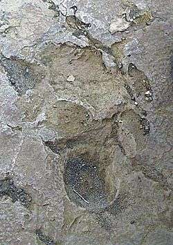 1790 Footprints |
August 7, 1974 (#74000351) |
9.1 miles south of park headquarters on Hawaiʻi Route 11, then along a foot trail to the southeast for 1 mile 19°23′00″N 155°20′07″W |
Hawaiʻi Volcanoes National Park | Footprints left in solidified ash from Kilauea eruption |
| 2 | Ahole Holua Complex | November 26, 1973 (#73000655) |
South of Milolii on Ahole Bay 19°08′27″N 155°54′58″W |
Miloliʻi | ||
| 3 | Ahu A ʻUmi Heiau | 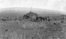 Ahu A ʻUmi Heiau |
August 13, 1974 (#74000343) |
Address Restricted |
North Kona | Royal complex on high remote plateau |
| 4 | Ainahou Ranch | 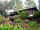 Ainahou Ranch |
February 8, 1995 (#94001619) |
Off Chain of Craters Road in Hawaiʻi Volcanoes National Park 19°20′37″N 155°13′44″W |
Hawaii Volcanoes National Park | Built by Shipman family as refuge from World War II, used to raise endangered Hawaiian goose |
| 5 | Ainapo Trail | 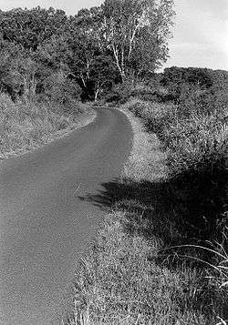 Ainapo Trail |
August 30, 1974 (#74000290) |
Hawaii Volcanoes National Park 19°27′39″N 155°34′39″W |
Mauna Loa | Ancient trail to the Mokuaweoweo summit |
| 6 | Ala Loa | Ala Loa |
June 5, 1987 (#87001127) |
Off Hawaiʻi Route 19 from Kiholo bay to Kalahuipaua'a 19°53′49″N 155°54′02″W |
South Kohala | Part of Ala Kahakai National Historic Trail |
| 7 | Anna Ranch | 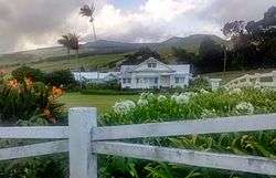 Anna Ranch |
April 28, 2008 (#06001120) |
65-1480 Kawaihae Rd. 20°01′23″N 155°45′59″W |
Kamuela | |
| 8 | Bank of Hawai'i, Ltd. | 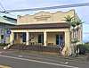 Bank of Hawai'i, Ltd. |
April 30, 2018 (#100002360) |
45-3568 Māmane St. 20°04′44″N 155°28′03″W |
Honokaʻa | |
| 9 | Bobcat Trail Habitation Cave (50-10-30-5004) | May 15, 1986 (#86001086) |
Address Restricted |
Pohakuloa | ||
| 10 | Bond District | 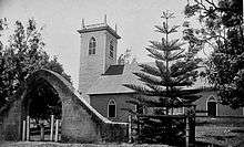 Bond District |
March 30, 1978 (#78001016) |
Southeast of Kapaau off Hawaii Route 270 20°13′33″N 155°47′33″W |
Kapaau | Homestead of Elias Bond, Kalahikiola Church, and Kohala Seminary |
| 11 | M.S. Botelho Building and Garage | 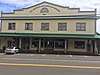 M.S. Botelho Building and Garage |
March 15, 2018 (#100002214) |
45-3490 Māmane St. 20°04′42″N 155°27′57″W |
Honokaʻa | |
| 12 | Francis H. Ii Brown House | August 21, 1986 (#86001616) |
Keawaiki Bay 19°53′16″N 155°54′22″W |
Waimea | Beach home for golfing champion Francis Hyde ʻĪʻī Brown (1892–1976) | |
| 13 | Chee Ying Society | July 20, 1978 (#78001014) |
Hawaii Route 24 20°05′05″N 155°28′34″W |
Honokaʻa | ||
| 14 | Daifukuji Soto Zen Mission |  Daifukuji Soto Zen Mission |
April 21, 1994 (#94000382) |
Mamalahoa Highway 19°32′32″N 155°55′41″W |
Honalo | Buddhist Temple built 1920–1921 |
| 15 | District Courthouse and Police Station | 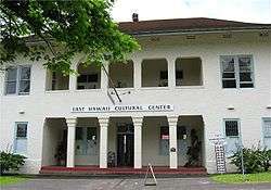 District Courthouse and Police Station |
September 4, 1979 (#79000752) |
141 Kalakaua St. 19°43′46″N 155°05′17″W |
Hilo | Built in 1932; now home of East Hawaii Cultural Center |
| 16 | Ferreira Building | 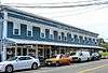 Ferreira Building |
October 29, 2015 (#15000756) |
45-3625 Māmane St. 20°04′45″N 155°28′10″W |
Honokaʻa | |
| 17 | First Bank of Hilo, Ltd. |  First Bank of Hilo, Ltd. |
December 28, 2017 (#100001916) |
45-3490 Māmane St., Unit G 20°04′42″N 155°27′57″W |
Honokaʻa | |
| 18 | Matsujiro Fujino Property | August 19, 2019 (#100004285) |
45-3390 Māmane St. 20°04′38″N 155°27′47″W |
Honokaʻa | ||
| 19 | Greenwell Store | 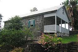 Greenwell Store |
May 22, 1978 (#78001017) |
Hawaii Route 11 19°30′55″N 155°55′24″W |
Kealakekua | Store built in 1870 now houses the Kona Historical Society Museum |
| 20 | Thomas Guard House | 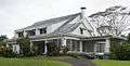 Thomas Guard House |
December 23, 2003 (#03001311) |
240 Kaʻiulani St. 19°43′40″N 155°06′03″W |
Hilo | Neoclassical style home, architects Clinton Briggs Ripley and Louis Davis (architect) |
| 21 | Hale Halawai O Holualoa | 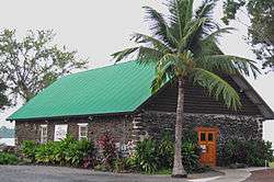 Hale Halawai O Holualoa |
June 5, 1987 (#87000794) |
76-6224 Aliʻi Dr. 19°36′36″N 155°58′41″W |
Kailua-Kona | Known as the "Living Stones Church" |
| 22 | S. Hata Building | 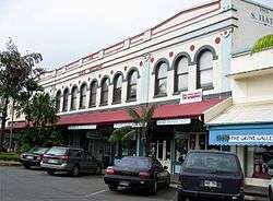 S. Hata Building |
August 27, 1991 (#91001087) |
318 Kamehameha Ave. 19°43′41″N 155°05′17″W |
Hilo | Built by Japanese American family business in 1912 |
| 23 | Heiau in Kukuipahu | April 24, 1973 (#73000652) |
Address Restricted |
Hawi | ||
| 24 | International Longshore and Warehouse Union (ILWU) Jack Wayne Hall Building | October 23, 2018 (#100001917) |
45-3720 Honoka'a-Waipi'o Rd. 20°04′48″N 155°28′19″W |
Honoka'a | ||
| 25 | Walter Irving and Jean Henderson House | 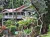 Walter Irving and Jean Henderson House |
February 28, 2011 (#11000057) |
82 Halaulani Place 19°43′58″N 155°05′29″W |
Hilo | Halaulani Place, 1917-1960 MPS; Craftsman bungalow built 1925 |
| 26 | Hilina Pali Road | .tif.jpg) Hilina Pali Road |
January 14, 2015 (#09000587) |
Hawaii Volcanoes National Park 19°24′06″N 155°15′56″W |
Hilo vicinity | |
| 27 | W.H. Hill House |  W.H. Hill House |
February 28, 2011 (#11000055) |
91 Halaulani Place 19°44′00″N 155°05′28″W |
Hilo | Halaulani Place, 1917-1960 MPS; Craftsman bungalow built 1919 |
| 28 | Hilo Masonic Lodge Hall-Bishop Trust Building | 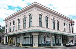 Hilo Masonic Lodge Hall-Bishop Trust Building |
April 21, 1994 (#94000383) |
Junction of Keawe and Waianuenue Streets 19°43′33″N 155°05′17″W |
Hilo | Also known as the Kaikodo (Restaurant) Building |
| 29 | James M. Hind House |  James M. Hind House |
February 3, 1994 (#93001557) |
Skilled Camp, House J 20°06′58″N 155°34′51″W |
Hawi | |
| 30 | Holualoa 4 Archeological District (State Site No. 50-10-37-23.661) |  Holualoa 4 Archeological District (State Site No. 50-10-37-23.661) |
June 8, 2005 (#05000542) |
Aliʻi Drive 19°36′21″N 155°58′39″W |
Kailua-Kona | Complex of temples and royal residences |
| 31 | Honokaa People's Theatre |  Honokaa People's Theatre |
October 6, 2015 (#15000684) |
45-3574 Māmane St. 20°04′45″N 155°28′04″W |
Honokaʻa | |
| 32 | Honoka'a Public Library | January 16, 2020 (#100004874) |
45-3380 Mamane St., Bldg. # 3 20°04′37″N 155°27′45″W |
Honokaʻa | ||
| 33 | Honoka'a United Methodist Church |  Honoka'a United Methodist Church |
December 21, 2017 (#100001413) |
45-3525 Māmane St. 20°04′43″N 155°27′59″W |
Honokaʻa | |
| 34 | Honokohau Settlement |  Honokohau Settlement |
October 15, 1966 (#66000287) |
Address Restricted |
Kailua-Kona | Inside Kaloko-Honokohau National Historical Park |
| 35 | Hotel Honokaa Club |  Hotel Honokaa Club |
October 6, 2015 (#15000685) |
45-3480 Māmane St. 20°04′42″N 155°27′55″W |
Honokaʻa | |
| 36 | Huliheʻe Palace |  Huliheʻe Palace |
May 25, 1973 (#73000653) |
Aliʻi Drive 19°38′32″N 155°59′51″W |
Kailua-Kona | Built by Governor Kuakini |
| 37 | Imiola Church | 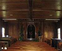 Imiola Church |
August 28, 1975 (#75000618) |
Northeast of Waimea on Hawaii Route 19 20°01′50″N 155°39′56″W |
Waimea | 1855 church with solid koa wood interior |
| 38 | Kahaluu Historic District |  Kahaluu Historic District |
December 27, 1974 (#74000713) |
Address Restricted |
Holualoa | Complex of temples and royal residences |
| 39 | Kahikolu Church | 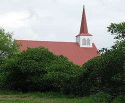 Kahikolu Church |
November 15, 1982 (#82000148) |
Southeast of Napoopoo 19°28′10″N 155°54′55″W |
Napoopoo | Built in 1852 on ruins of 1833 church |
| 40 | Kalaoa Permanent House Site 10,205 | 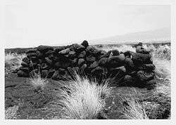 Kalaoa Permanent House Site 10,205 |
November 21, 1992 (#92001552) |
Near Kalihi Point, Natural Energy Laboratory of Hawaii 19°43′35″N 156°03′31″W |
Kailua-Kona | Ancient house site |
| 41 | Kaloko-Honokohau National Historical Park | Kaloko-Honokohau National Historical Park |
November 10, 1978 (#78003148) |
Island of Hawaii 19°41′05″N 156°01′22″W |
Kailua-Kona | Ancient fish ponds and settlement ruins |
| 42 | Kamakahonu, Residence Of King Kamehameha I |  Kamakahonu, Residence Of King Kamehameha I |
October 15, 1966 (#66000288) |
On the northwestern edge of Kailua Bay, north and west of Kailua Wharf 19°38′20″N 155°59′51″W |
Kailua-Kona | Kamehameha I lived here after unifying the islands |
| 43 | Kamehameha Hall | 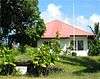 Kamehameha Hall |
May 20, 1993 (#93000426) |
1162 Kalanianaole Ave. 19°43′53″N 155°02′42″W |
Hilo | Meeting house of the Royal Order of Kamehameha I |
| 44 | Kamehameha III's Birthplace | 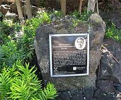 Kamehameha III's Birthplace |
July 24, 1978 (#78001018) |
Off Alii Dr. 19°34′00″N 155°57′50″W |
Keauhou | Marker at Keauhou Bay |
| 45 | Kamoa Point Complex |  Kamoa Point Complex |
July 14, 1983 (#83000247) |
Address Restricted |
Kailua-Kona | Royal complex on Holualoa Bay |
| 46 | Kealakekua Bay Historical District | 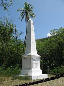 Kealakekua Bay Historical District |
December 12, 1973 (#73000651) |
Southwest of Captain Cook off Hawaii Route 11 19°28′29″N 155°55′27″W |
Captain Cook | Religious center in use during early European visits |
| 47 | Keauhou Holua Slide | 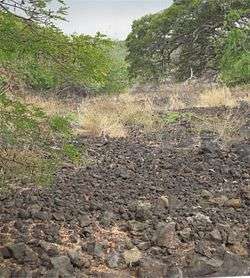 Keauhou Holua Slide |
October 15, 1966 (#66000290) |
East of Hawaii Route 18 19°33′44″N 155°57′30″W |
Keauhou | Hawaiian lava sledding "extreme sport" course |
| 48 | Kii Petroglyphs | July 12, 1984 (#84000919) |
Address Restricted |
Waiohinu | ||
| 49 | Kilauea Crater | Kilauea Crater |
July 24, 1974 (#74000291) |
Southwest of Hilo in Hawaii Volcanoes National Park 19°25′02″N 155°16′36″W |
Hilo | Active volcano is a world heritage site |
| 50 | Kohala District Courthouse | 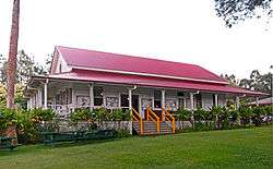 Kohala District Courthouse |
August 31, 1979 (#79000754) |
Government Rd. 20°13′59″N 155°48′03″W |
Kapaau | |
| 51 | Kamekichi and Mika Kotake Store Property | January 16, 2020 (#100001918) |
45-3620 Mamane St. 20°04′46″N 155°28′09″W |
Honoka'a | ||
| 52 | Kuamo'o Burials |  Kuamo'o Burials |
August 13, 1974 (#74000714) |
Address Restricted |
Kailua-Kona | Site of 1819 battle, South of Keauhou Bay |
| 53 | Lapakahi Complex | 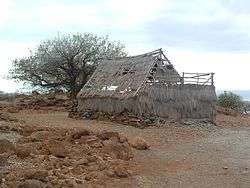 Lapakahi Complex |
July 2, 1973 (#73000654) |
Akoni Pule Highway 20°10′31″N 155°53′50″W |
Mahukona | Reconstructed ancient fishing village; State Historical Park and Marine Life Conservation District |
| 54 | Levi and Netti Lyman House | 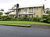 Levi and Netti Lyman House |
February 28, 2011 (#11000059) |
40 Halaulani Place 19°43′57″N 155°05′33″W |
Hilo | Halaulani Place, 1917-1960 MPS; Colonial revival built 1922 |
| 55 | Rev. D.B. Lyman House | 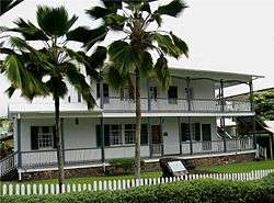 Rev. D.B. Lyman House |
March 24, 1978 (#78001012) |
276 Haili St. 19°43′38″N 155°05′35″W |
Hilo | 1838 missionary house is now a museum |
| 56 | Mahana Archeological District (50HA10230) | October 14, 1986 (#86002802) |
Address Restricted |
Naalehu | ||
| 57 | Manuka Bay Petroglyphs | September 19, 1973 (#73000656) |
Address Restricted |
Waiohinu | ||
| 58 | Mauna Kea Adz Quarry | October 15, 1966 (#66000285) |
24 miles northwest of Hilo[3] Coordinates missing |
Hilo | The largest primitive basalt quarry in the world | |
| 59 | Mauna Loa Road | .tif.jpg) Mauna Loa Road |
January 14, 2015 (#09000620) |
Hawaii Volcanoes National Park 19°26′15″N 155°18′10″W |
Hilo vicinity | |
| 60 | Mokuaikaua Church | 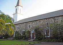 Mokuaikaua Church |
October 3, 1978 (#78001015) |
Off Hawaii Route 11 19°38′39″N 155°59′48″W |
Kailua-Kona | Oldest Christian Church in Hawaii |
| 61 | Mookini Heiau | 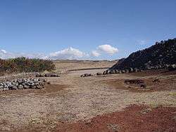 Mookini Heiau |
October 15, 1966 (#66000284) |
Northern tip of Hawaii, 1 mile west of Upolu Point Airport 20°15′44″N 155°52′59″W |
Hawi | State Monument includes Kamehameha I birthplace |
| 62 | Edward H. and Claire Moses House | 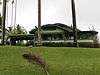 Edward H. and Claire Moses House |
February 28, 2011 (#11000056) |
105 Halaulani Place 19°43′59″N 155°05′32″W |
Hilo | Halaulani Place, 1917-1960 MPS; Craftsman bungalow built 1921 |
| 63 | A. Nanbu Hotel-Holy's Bakery | 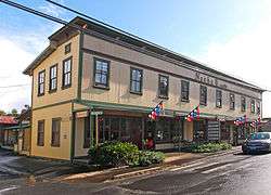 A. Nanbu Hotel-Holy's Bakery |
November 18, 1999 (#99001356) |
Akoni Pule Highway 20°13′55″N 155°47′57″W |
Kapaau | |
| 64 | Old Volcano House No. 42 | 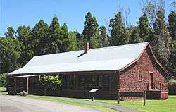 Old Volcano House No. 42 |
July 24, 1974 (#74000293) |
Southwest of Hilo on Hawaii Route 11 in Hawaii Volcanoes National Park 19°25′49″N 155°15′30″W |
Hilo | Built in 1877; now Volcano Art Center gallery |
| 65 | Palace Theater | 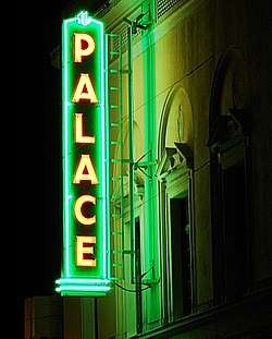 Palace Theater |
May 11, 1993 (#93000376) |
38 Haili St. 19°43′28″N 155°05′11″W |
Hilo | A movie theater built in 1925, today an arthouse |
| 66 | James and Catherine Parker House |  James and Catherine Parker House |
February 28, 2011 (#11000058) |
72 Halaulani Place 19°43′58″N 155°05′29″W |
Hilo | Halaulani Place, 1917-1960 MPS; Craftsman bungalow built 1924 |
| 67 | Pu'uhonua O Honaunau National Historical Park | 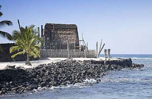 Pu'uhonua O Honaunau National Historical Park |
October 15, 1966 (#66000104) |
20 miles (32 km) south of Kailua-Kona 19°25′22″N 155°54′35″W |
Hōnaunau | Large ancient religious site formerly known as the "City of Refuge" |
| 68 | Pu'ukohola Heiau | 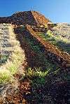 Pu'ukohola Heiau |
October 15, 1966 (#07001173) |
0.9 miles southeast of Kawaihae 20°01′35″N 155°49′12″W |
Kawaihae | Kamehameha I temple built in 1790 |
| 69 | Pu'ukohola Heiau National Historic Site | 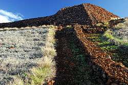 Pu'ukohola Heiau National Historic Site |
August 17, 1972 (#66000105) |
Northern end of Hawaii off Hawaii Route 26, about 1 mile southeast of Kawaihae 20°01′52″N 155°49′30″W |
Kawaihae | see above |
| 70 | Pua'a-2 Agricultural Fields Archeological District | October 14, 1986 (#86002804) |
Address Restricted |
Holualoa | Potentially destroyed[4] | |
| 71 | Puako Petroglyph Archeological District |  Puako Petroglyph Archeological District |
April 8, 1983[5] (#83000248) |
Address Restricted |
Puakō vicinity | |
| 72 | Puna-Ka'u Historic District | 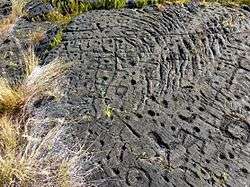 Puna-Ka'u Historic District |
July 1, 1974 (#74000294) |
Hawaii Volcanoes National Park 19°17′42″N 155°14′31″W |
Pāhala | |
| 73 | St. Benedict's Catholic Church | 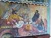 St. Benedict's Catholic Church |
May 31, 1979 (#79000753) |
Off Hawaii Route 11 19°26′21″N 155°53′33″W |
Hōnaunau | Another "Painted Church" |
| 74 | Masaaki Sakata Property | 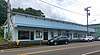 Masaaki Sakata Property |
August 7, 2017 (#100001414) |
45-3577 Māmane St. 20°04′44″N 155°28′05″W |
Honokaʻa | |
| 75 | W.H. Shipman House |  W.H. Shipman House |
June 23, 1978 (#78001013) |
141 Kaʻiulani Street 19°43′27″N 155°05′58″W |
Hilo | Built in 1899 for William Herbert Shipman, now a "Bed and Breakfast" Hotel |
| 76 | South Point Complex |  South Point Complex |
October 15, 1966 (#66000291) |
Southern point of Hawaii 18°54′57″N 155°40′35″W |
Naalehu | Southernmost point in the United States |
| 77 | Star of the Sea Church-Kalapana Painted Church | 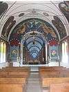 Star of the Sea Church-Kalapana Painted Church |
May 14, 1997 (#97000407) |
Hawaii Route 130, 0.7 miles north of Kaimu 19°22′34″N 154°58′01″W |
Kaimu | Small church near villages destroyed by lava flows |
| 78 | Tong Wo Society Building | June 9, 1978 (#78001011) |
Hawaii Route 27 20°13′40″N 155°46′10″W |
Halaula | ||
| 79 | Herbert Austin Truslow House | 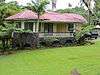 Herbert Austin Truslow House |
February 28, 2011 (#11000060) |
52 Halaulani Place 19°43′57″N 155°05′31″W |
Hilo | Halaulani Place, 1917-1960 MPS; Craftsman bungalow built 1920 |
| 80 | U.S. Post Office and Office Building | 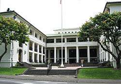 U.S. Post Office and Office Building |
October 1, 1974 (#74000708) |
Kinoole and Waianuenue Sts. 19°43′49″N 155°05′31″W |
Hilo | Built in 1915, still used as Federal offices |
| 81 | Uchida Coffee Farm |  Uchida Coffee Farm |
February 9, 1995 (#94001621) |
Off Mamalahoa Highway 19°29′24″N 155°54′49″W |
Kealakekua | Restored Japanese Kona coffee farm |
| 82 | Volcano Block Building | 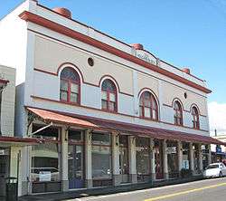 Volcano Block Building |
January 7, 1993 (#92001748) |
27-37 Waianuenue Ave. 19°43′44″N 155°05′24″W |
Hilo | Commercial building built in 1914 with notable tenants |
| 83 | Waiakea Mission Station-Hilo Station | 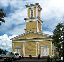 Waiakea Mission Station-Hilo Station |
April 23, 2002 (#02000387) |
211 Haili St. 19°43′37″N 155°05′31″W |
Hilo | Haili Church built by Titus Coan 1854 |
| 84 | Waimea Elementary School |  Waimea Elementary School |
June 8, 2005 (#05000541) |
Hawaii Route 19, Kawaihae Rd. TMK (3)6-5-07:3 20°01′25″N 155°40′21″W |
Kamuela | First schoolhouse serving Waimea community and example of early Hawaiian plantation style |
| 85 | Whitney Seismograph Vault No. 29 |  Whitney Seismograph Vault No. 29 |
July 24, 1974 (#74000292) |
Southwest of Hilo on Hawaii Route 11 in Hawaii Volcanoes National Park 19°25′59″N 155°15′40″W |
Hilo | Original home of Hawaiian Volcano Observatory founded by Thomas Jaggar in 1912 |
| 86 | Wilkes Campsite | 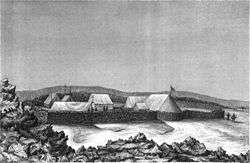 Wilkes Campsite |
July 24, 1974 (#74000295) |
West of Hilo at Mauna Loa Volcano in Hawaii Volcanoes National Park 19°28′14″N 155°35′06″W |
Hilo | Ruins of 1840 Charles Wilkes camp site at Mokuaweoweo summit |
| 87 | A.J. Williamson House | 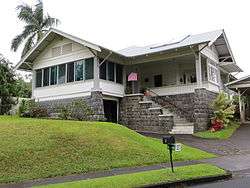 A.J. Williamson House |
May 9, 1997 (#97000406) |
31 Halaulani Pl. 19°44′11″N 155°05′44″W |
Hilo | Craftsman bungalow built 1921 |
| 88 | Teiji Yamatsuka Store | 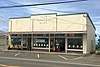 Teiji Yamatsuka Store |
March 12, 2018 (#100001415) |
45-3590 Māmane St. 20°04′45″N 155°28′06″W |
Honokaʻa |
See also
| Wikimedia Commons has media related to National Register of Historic Places in Hawaii. |
References
- Numbers represent an ordering by significant words. Various colorings, defined here, differentiate National Historic Landmarks and historic districts from other NRHP buildings, structures, sites or objects.
- The eight-digit number below each date is the number assigned to each location in the National Register Information System database, which can be viewed by clicking the number.
- Location derived from this National Park Service website; the NRIS lists it as "Address Restricted"
- State approved permits to bulldoze ancient sites in Honolulu Advertiser, May 10, 2007
- National Park Service (April 13, 1983), Weekly announcement of National Register of Historic Places actions (PDF), p. 61-63.
External links
| Topics | |
|---|---|
| Lists by state |
|
| Lists by insular areas | |
| Lists by associated state | |
| Other areas | |
| Related | |
| |
Islands, municipalities, and communities of Hawaii County, Hawaii, United States | ||
|---|---|---|
| CDPs |
|  Map of Hawaii highlighting Hawaii County |
| Unincorporated communities | ||
| Districts | ||
This article is issued from Wikipedia. The text is licensed under Creative Commons - Attribution - Sharealike. Additional terms may apply for the media files.