Volcano, Hawaii
Volcano is a census-designated place (CDP) in Hawaii County, Hawaii, United States located in the District of Puna with a small portion of the CDP in the District of Kaʻū. The population was 2,575 at the 2010 census,[1] up from 2,231 at the 2000 census.
Volcano, Hawaii | |
|---|---|
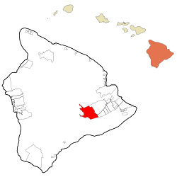 Location in Hawaii County and the state of Hawaii | |
 Volcano Location in Hawaii | |
| Coordinates: 19°26′59″N 155°14′8″W | |
| Country | United States |
| State | Hawaii |
| County | Hawaii |
| Area | |
| • Total | 58.6 sq mi (151.7 km2) |
| • Land | 58.6 sq mi (151.7 km2) |
| • Water | 0.0 sq mi (0.0 km2) |
| Elevation | 3,750 ft (1,143 m) |
| Population (2010) | |
| • Total | 2,575 |
| • Density | 44/sq mi (17.0/km2) |
| Time zone | UTC-10 (Hawaii-Aleutian) |
| ZIP code | 96785 |
| Area code(s) | 808 |
| FIPS code | 15-72350 |
| GNIS feature ID | 0364402 |
Geography and climate
Volcano is located on the east side of the island of Hawaiʻi,[2] on the border of Hawaii Volcanoes National Park and near the northeast rim of Kīlauea's summit caldera.
According to the United States Census Bureau, the CDP has a total area of 58.6 square miles (151.7 km2), all of it land.[3] Hawaii Route 11 passes through the southern part of the community, leading northeast 27 miles (43 km) to Hilo and southwest 37 miles (60 km) to Nāʻālehu.
Owing to its altitude, ranging from below 2,800 feet (850 m) in the southeast to over 6,200 feet (1,900 m) at its uninhabited northern end, Volcano features a subtropical highland climate (Köppen Cfb), with relatively uniform temperatures and abundant rainfall throughout the year, although rainfall is concentrated during the months of November through April. The hardiness zone is 11a.
| Climate data for Volcano, HI | |||||||||||||
|---|---|---|---|---|---|---|---|---|---|---|---|---|---|
| Month | Jan | Feb | Mar | Apr | May | Jun | Jul | Aug | Sep | Oct | Nov | Dec | Year |
| Record high °F (°C) | 79 (26) |
82 (28) |
80 (27) |
81 (27) |
81 (27) |
83 (28) |
87 (31) |
84 (29) |
85 (29) |
81 (27) |
80 (27) |
81 (27) |
87 (31) |
| Average high °F (°C) | 67.1 (19.5) |
66.9 (19.4) |
66.6 (19.2) |
67.1 (19.5) |
68.9 (20.5) |
72.0 (22.2) |
71.4 (21.9) |
72.3 (22.4) |
72.3 (22.4) |
71.6 (22.0) |
69.1 (20.6) |
67.1 (19.5) |
69.2 (20.7) |
| Daily mean °F (°C) | 58.4 (14.7) |
58.2 (14.6) |
58.5 (14.7) |
59.3 (15.2) |
60.8 (16.0) |
62.0 (16.7) |
63.2 (17.3) |
63.9 (17.7) |
63.7 (17.6) |
63.1 (17.3) |
61.2 (16.2) |
59.2 (15.1) |
60.9 (16.1) |
| Average low °F (°C) | 49.6 (9.8) |
49.5 (9.7) |
50.4 (10.2) |
51.6 (10.9) |
52.7 (11.5) |
53.8 (12.1) |
55 (13) |
55.4 (13.0) |
54.9 (12.7) |
54.6 (12.6) |
53.3 (11.8) |
51.2 (10.7) |
52.7 (11.5) |
| Record low °F (°C) | 34 (1) |
35 (2) |
38 (3) |
40 (4) |
44 (7) |
42 (6) |
45 (7) |
41 (5) |
45 (7) |
45 (7) |
41 (5) |
35 (2) |
34 (1) |
| Average rainfall inches (mm) | 12.9 (330) |
10.4 (260) |
12.7 (320) |
10.5 (270) |
7.1 (180) |
4.8 (120) |
6.2 (160) |
6.7 (170) |
5.4 (140) |
6.8 (170) |
12.6 (320) |
11.7 (300) |
107.7 (2,740) |
| Average rainy days (≥ 0.01 in) | 22 | 20 | 25 | 26 | 26 | 24 | 25 | 24 | 23 | 25 | 24 | 24 | 288 |
| Source: Weatherbase(records),[4] | |||||||||||||
Demographics
2010 census
At the 2010 census, there were 2,575 people in 1,228 households residing in the CDP. The population density was 45.4 people per square mile (17.5/km²). There were 1,740 housing units at an average density of 30.7 per square mile (11.9/km²). The racial makeup of the CDP was 51.53% White, 0.74% African American, 0.39% American Indian & Alaska Native, 11.57% Asian, 9.79% Native Hawaiian & Pacific Islander, 0.43% from other races, and 25.55% from two or more races. Hispanic or Latino of any race were 8.82% of the population.[1]
Of the 1,228 households 17.6% had children under the age of 18 living with them. The average household size was 2.10.[1]
In the Volcano CDP the population was spread out with 17.3% under the age of 18, 5.4% from 18 to 24, 8.8% from 25 to 34, 16.4% from 35 to 49, 34.6% from 50 to 64, and 17.5% 65 or older. For every 100 females, there were 99.3 males. For every 100 males there were 100.7 females.[1]
The median household income was $35,977 and the median family income in 2000 was $44,432. Males had a median income of $30,929 in 2000 versus $31,679 for females. The per capita income for the CDP in 2000 was $18,913. About 10.4% of families and 14.3% of the population were below the poverty line in 2000, including 15.0% of those under age 18 and 2.3% of those age 65 or over.
2000 census
At the 2000 census there were 2,231 people, 896 households, and 498 families in the CDP. The population density was 39.4 people per square mile (15.2/km²). There were 1,229 housing units at an average density of 21.7 per square mile (8.4/km²). The racial makeup of the CDP was 47.87% White, 0.49% African American, 0.54% Native American, 11.39% Asian, 12.24% Pacific Islander, 1.34% from other races, and 26.13% from two or more races. Hispanic or Latino of any race were 9.28%.[5]
Of the 896 households 24.6% had children under the age of 18 living with them, 41.4% were married couples living together, 9.5% had a female householder with no husband present, and 44.4% were non-families. 34.7% of households were one person and 7.5% were one person aged 65 or older. The average household size was 2.25 and the average family size was 2.92.
The age distribution was 20.3% under the age of 18, 6.7% from 18 to 24, 30.7% from 25 to 44, 30.3% from 45 to 64, and 11.9% 65 or older. The median age was 41 years. For every 100 females, there were 116.2 males. For every 100 females age 18 and over, there were 125.2 males.
The median household income was $35,977 and the median family income was $44,432. Males had a median income of $30,929 versus $31,679 for females. The per capita income for the CDP was $18,913. About 10.4% of families and 14.3% of the population were below the poverty line, including 15.0% of those under age 18 and 2.3% of those age 65 or over.
Notable residents
- Garrett Hongo (b. 1951), poet, current professor of creative writing at the University of Oregon
- Jason Scott Lee (b. 1966), actor, martial artist, founder of the Ulua Theatre in Volcano[6]
- Dietrich Varez (1939-2018) Dietrich Varez (born in Berlin, Germany) printmaker-painter.[7]
References
- US Census Bureau - 2010 Population Finder - Volcano CDP
- "US Gazetteer files: 2010, 2000, and 1990". United States Census Bureau. 2011-02-12. Retrieved 2011-04-23.
- "Geographic Identifiers: 2010 Demographic Profile Data (G001): Volcano CDP, Hawaii". American Factfinder. U.S. Census Bureau. Retrieved June 7, 2017.
- "Monthly Averages for Volcano, HI". Weatherbase. Retrieved 2013-04-22.
- "U.S. Census website". United States Census Bureau. Retrieved 2008-01-31.
- Honolulu Magazine - October 2005
- Dietrich Varez
Islands, municipalities, and communities of Hawaii County, Hawaii, United States | ||
|---|---|---|
| CDPs |
| 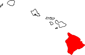 Map of Hawaii highlighting Hawaii County |
| Unincorporated communities | ||
| Districts | ||