Waikoloa Village, Hawaii
Waikōloa Village is a census-designated place (CDP) in Hawaiʻi County, Hawaii, United States. The population was 6,362 at the 2010 census,[1] up from 4,806 at the 2000 census. The name Waikoloa is used by the local post office.[2]
Waikoloa Village, Hawaii Waikōloa Village Waikoloa, Waikōloa | |
|---|---|
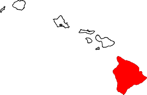
 Location in Hawaii County and the state of Hawaii | |
| Coordinates: 19°56′29″N 155°47′34″W | |
| Country | United States |
| State | Hawaii |
| County | Hawaii |
| Area | |
| • Total | 17.8 sq mi (46.2 km2) |
| • Land | 17.8 sq mi (46.2 km2) |
| • Water | 0.0 sq mi (0.0 km2) |
| Elevation | 410 ft (125 m) |
| Population (2010) | |
| • Total | 6,362 |
| • Density | 357/sq mi (137.8/km2) |
| Time zone | UTC-10 (Hawaii-Aleutian) |
| ZIP Code | 96738 |
| Area code(s) | 808 |
| FIPS code | 15-76600 |
| GNIS feature ID | 1867263 |
Geography
Waikōloa Village is located on the west side of the island of Hawaiʻi at 19°56′29″N 155°47′34″W (19.941445, −155.792655).[3] It is bordered to the west by Puako. Hawaii Route 19 forms the border between the two communities; it leads northeast 14 miles (23 km) to Waimea and southwest 28 miles (45 km) to Kailua-Kona.
| Climate data for Waikoloa Village | |||||||||||||
|---|---|---|---|---|---|---|---|---|---|---|---|---|---|
| Month | Jan | Feb | Mar | Apr | May | Jun | Jul | Aug | Sep | Oct | Nov | Dec | Year |
| Average precipitation inches | 1.8 | 1.3 | 1.2 | 0.8 | 0.8 | 0.5 | 0.3 | 0.4 | 0.7 | 0.9 | 0.8 | 1.6 | 11.1 |
| Average precipitation mm | 46 | 33 | 30 | 20 | 20 | 13 | 7.6 | 10 | 18 | 23 | 20 | 41 | 281.6 |
| Source: [4] | |||||||||||||
According to the United States Census Bureau, the Waikōloa Village CDP has a total area of 17.8 square miles (46.2 km2), all of it land.[1]
Demographics
At the 2000 census there were 4,806 people, 1,750 households, and 1,225 families in the CDP. The population density was 251.1 people per square mile (96.9/km²). There were 2,057 housing units at an average density of 107.5 per square mile (41.5/km²). The racial makeup of the CDP was 45.92% White, 0.48% African American, 0.21% Native American, 16.65% Asian, 9.20% Pacific Islander, 1.46% from other races, and 26.09% from two or more races. Hispanic or Latino of any race were 8.99%.[5]
Of the 1,750 households 41.2% had children under the age of 18 living with them, 51.5% were married couples living together, 13.0% had a female householder with no husband present, and 30.0% were non-families. 19.7% of households were one person and 3.6% were one person aged 65 or older. The average household size was 2.74 and the average family size was 3.15.
The age distribution was 29.9% under the age of 18, 6.2% from 18 to 24, 34.2% from 25 to 44, 23.0% from 45 to 64, and 6.7% 65 or older. The median age was 35 years. For every 100 females, there were 104.3 males. For every 100 females age 18 and over, there were 101.0 males.
The median household income was $50,040 and the median family income was $55,222. Males had a median income of $36,134 versus $30,881 for females. The per capita income for the CDP was $21,328. About 8.6% of families and 10.4% of the population were below the poverty line, including 14.2% of those under age 18 and 1.8% of those age 65 or over.
See also
References
- "Geographic Identifiers: 2010 Demographic Profile Data (G001): Waikoloa Village CDP, Hawaii". American Factfinder. U.S. Census Bureau. Retrieved June 7, 2017.
- Zip Code Lookup
- "US Gazetteer files: 2010, 2000, and 1990". United States Census Bureau. 2011-02-12. Retrieved 2011-04-23.
- "Monthly Averages for Tallulah, LA". weatherbase.com. Retrieved 2017-11-29.
- "U.S. Census website". United States Census Bureau. Retrieved 2008-01-31.
External links
| Wikimedia Commons has media related to Waikoloa Village, Hawaii. |
Islands, municipalities, and communities of Hawaii County, Hawaii, United States | ||
|---|---|---|
| CDPs |
|  Map of Hawaii highlighting Hawaii County |
| Unincorporated communities | ||
| Districts | ||