Keaau, Hawaii
Keaʻau (also written as Keaau) is a census-designated place (CDP) in Hawaiʻi County, Hawaii, United States located in the District of Puna. The population was 2,010 at the 2000 census. The population increased by 12.1% to 2,253 at the 2010 census.[1]
Keaʻau, Hawaii Keaʻau | |
|---|---|
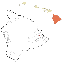 Location in Hawaiʻi County and the state of Hawaii | |
| Coordinates: 19°37′16″N 155°2′30″W | |
| Country | United States |
| State | Hawaii |
| County | Hawaiʻi |
| Area | |
| • Total | 2.6 sq mi (6.7 km2) |
| • Land | 2.6 sq mi (6.7 km2) |
| • Water | 0.0 sq mi (0.0 km2) |
| Elevation | 341 ft (104 m) |
| Population (2010) | |
| • Total | 2,253 |
| • Density | 875/sq mi (337.8/km2) |
| Time zone | UTC-10 (Hawaii-Aleutian) |
| ZIP code | 96749 |
| Area code(s) | 808 |
| FIPS code | 15-32900 |
| GNIS feature ID | 0360892 |
Geography
Keaʻau is on the east side of the island of Hawaiʻi at 19°37′16″N 155°2′30″W (19.621072, -155.041706).[2] It is bordered to the southwest by Kurtistown. Hilo is 8 miles (13 km) to the north. The junction of Hawaii Route 11 (the Hawaii Belt Road) and Hawaii Route 130 (Keaau-Pahoa Road) is in the northern part of the community. According to the United States Census Bureau, the CDP has a total area of 2.6 square miles (6.7 km2), all of it land.[3]
The Board on Geographic Names officially designated the populated place as Keaʻau in 2003.[4]
Demographics
2010 Census data
At the 2010 census there were 2,253 people in 701 households residing in the CDP. The population density was 901.2 people per square mile (352.0/km²). There were 757 housing units at an average density of 302.8 per square mile (118.3/km²). The racial makeup of the CDP was 12.38% White, 0.22% African American, 0.18% American Indian & Alaska Native, 52.02% Asian, 7.50% Native Hawaiian & Pacific Islander, 0.44% from other races, and 27.25% from two or more races. Hispanic or Latino of any race were 8.74%.[1][5]
Of the 701 households 28.0% had children under the age of 18 living with them. The average household size was 3.21.[1]
In the Keaʻau CDP the population was spread out with 23.7% under the age of 18, 9.5% from 18 to 24, 9.6% from 25 to 34, 19.6 from 35 to 49, 20.4% from 50 to 64, and 17.2% 65 or older. For every 100 females, there were 99.6 males. For every 100 males there were 100.4 females.[1]
The median household income was $39,722 and the median family income in 2000 was $43,347. Males had a median income in 2000 of $27,344 versus $23,287 for females. The per capita income for the CDP in 2000 was $14,657. About 9.6% of families and 12.3% of the population were below the poverty line in 2000, including 14.9% of those under age 18 and 9.0% of those age 65 or over.
Points of interest
- Hiʻiaka's Healing Herb Garden
- Mauna Loa Macadamia Nut Corporation visitors center between Hilo and Keaʻau[6]
References
- "US Census Bureau - 2010 Population Finder - Keaau CDP". Archived from the original on 2014-01-16. Retrieved 2017-12-06.
- "US Gazetteer files: 2010, 2000, and 1990". United States Census Bureau. 2011-02-12. Retrieved 2011-04-23.
- "Geographic Identifiers: 2010 Demographic Profile Data (G001): Keaau CDP, Hawaii". American Factfinder. U.S. Census Bureau. Retrieved May 31, 2017.
- cf. U.S. Geological Survey Geographic Names Information System: Keaʻau
- "U.S. Census website". United States Census Bureau. Retrieved 2008-01-31.
- "Mauna Loa Macadamia Nut Factory & Visitors Center". on GoHawaii.Com official state tourism web site. Hawaii Visitors and Convention Bureau. Archived from the original on 2011-07-16. Retrieved 2009-08-25.
Islands, municipalities, and communities of Hawaii County, Hawaii, United States | ||
|---|---|---|
| CDPs |
| 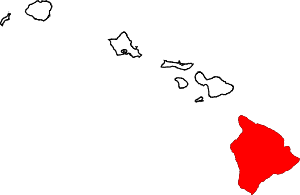 Map of Hawaii highlighting Hawaii County |
| Unincorporated communities | ||
| Districts | ||