National Register of Historic Places listings in outer Harris County, Texas
This is a list of the National Register of Historic Places in outer Harris County, Texas. It is intended to be a complete list of properties and districts listed on the National Register of Historic Places in outer portion of Harris County, Texas, United States, defined as outside the I-610 loop. The locations of National Register properties and districts (at least for all showing latitude and longitude coordinates below) may be seen in a map by clicking on "Map of all coordinates."[1]
Included is a cluster of seven current listings in the historic black neighborhood of Independence Heights, Houston. Another cluster of three listings are NASA structures at the Lyndon B. Johnson Space Center.
| downtown Houston - Houston Heights - inner Harris County - outer Harris County |
- This National Park Service list is complete through NPS recent listings posted June 19, 2020.[2]
Current listings
| [3] | Name on the Register | Image | Date listed[4] | Location | City or town | Description |
|---|---|---|---|---|---|---|
| 1 | Apollo Mission Control Center | 116.jpg) Apollo Mission Control Center |
October 3, 1985 (#85002815) |
Lyndon B. Johnson Space Flight Center 29°33′29″N 95°05′18″W |
Houston | |
| 2 | Armand Bayou Archeological District |  Armand Bayou Archeological District |
December 12, 1978 (#78002952) |
Address Restricted |
Pasadena | |
| 3 | Barker-Cypress Archeological Site (41HR436) | April 24, 1984 (#84001753) |
Address Restricted |
Houston | ||
| 4 | Cedar Bayou Archeological District | March 2, 1979 (#79002952) |
Address Restricted |
Baytown | ||
| 5 | Ben C. and Jenetter Cyrus House | .jpg) Ben C. and Jenetter Cyrus House |
June 4, 1997 (#97000549) |
325 E. 25th St. 29°49′05″N 95°23′33″W |
Houston | |
| 6 | Harris County Boy's School Site | 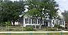 Harris County Boy's School Site |
May 2, 1979 (#79002961) |
Address Restricted |
Houston | It is an archeological site with middens and burials.[5] |
| 7 | Houston Municipal Airport Terminal | 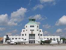 Houston Municipal Airport Terminal |
March 6, 2019 (#100003488) |
8325 Travelair Rd. 29°38′49″N 95°17′10″W |
Houston | |
| 8 | Houston National Cemetery |  Houston National Cemetery |
February 28, 2017 (#100000697) |
10410 Veterans Memorial Dr. 29°55′51″N 95°27′02″W |
Houston | |
| 9 | Independence Heights Residential Historic District | .jpg) Independence Heights Residential Historic District |
June 4, 1997 (#97000542) |
Roughly bounded by N. Yale and E. 34th Sts., and I-610 29°48′54″N 95°23′45″W |
Houston | Independence Heights |
| 10 | Independence Park | 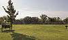 Independence Park |
June 4, 1997 (#97000544) |
Roughly bounded by 1000 Blk. of E. 40th St. 29°49′21″N 95°23′11″W |
Houston | |
| 11 | Charles Johnson House | .jpg) Charles Johnson House |
June 4, 1997 (#97000550) |
301 E. 35th St. 29°49′05″N 95°23′45″W |
Houston | Independence Heights |
| 12 | Ella Lewis Store and Rental Houses | .jpg) Ella Lewis Store and Rental Houses |
June 4, 1997 (#97000543) |
3404-3406-3408 Cortlandt St. 29°49′02″N 95°23′44″W |
Houston | Independence Heights |
| 13 | Oscar Lindsay House | .jpg) Oscar Lindsay House |
June 4, 1997 (#97000546) |
7415 N. Main St. 29°49′02″N 95°23′34″W |
Houston | Independence Heights |
| 14 | William Mackey House | June 4, 1997 (#97000547) |
313 E. 37th St. 29°49′12″N 95°23′43″W |
Houston | Independence Heights | |
| 15 | Mansfield Street Archeological Site | May 22, 1978 (#78002945) |
Address Restricted |
Houston | ||
| 16 | Morgan's Point Historic District | 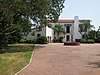 Morgan's Point Historic District |
September 30, 1994 (#94001160) |
89-835 Bayridge Rd. and 300-322 Vinsonia 29°40′13″N 94°59′39″W |
Morgan's Point | |
| 17 | Pomeroy Homestead | May 1, 2003 (#03000329) |
202 and 204 S. Main St. 29°42′38″N 95°12′35″W |
Pasadena | ||
| 18 | San Jacinto Battlefield |  San Jacinto Battlefield |
October 15, 1966 (#66000815) |
22 mi (35 km). E of Houston on TX 134 29°44′56″N 95°04′49″W |
Houston | |
| 19 | Saturn V Launch Vehicle | 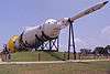 Saturn V Launch Vehicle |
February 4, 2003 (#02001731) |
Johnson Space Center 29°33′26″N 95°05′20″W |
Houston | |
| 20 | Space Environment Simulation Laboratory | .jpg) Space Environment Simulation Laboratory |
October 3, 1985 (#85002810) |
Lyndon B. Johnson Space Center 29°33′38″N 95°05′17″W |
Houston | |
| 21 | State Highway 35 Bridge at the West Fork of the San Jacinto River | 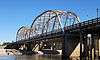 State Highway 35 Bridge at the West Fork of the San Jacinto River |
October 10, 1996 (#96001110) |
US 59, 1.4 mi (2.3 km). N of jct. with FM 1960 30°01′39″N 95°15′28″W |
Humble | |
| 22 | Sterling S. Ross House | 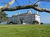 Sterling S. Ross House |
October 29, 1982 (#82004858) |
515 Bayridge Rd. 29°40′07″N 94°59′42″W |
Morgan's Point | |
| 23 | Dr. James M. and Dove Stewart House | 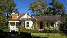 Dr. James M. and Dove Stewart House |
February 16, 1996 (#96000067) |
5702 Fourth St. 29°47′21″N 95°49′21″W |
Katy | |
| 24 | Sylvan Beach Pavilion |  Sylvan Beach Pavilion |
September 9, 2010 (#10000738) |
554 N Bayshore Dr. 29°39′04″N 95°00′38″W |
La Porte | |
| 25 | U.S.S. TEXAS | 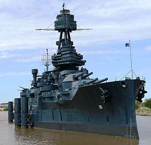 U.S.S. TEXAS |
December 8, 1976 (#76002039) |
22 mi (35 km). E of Houston on TX 134 at San Jacinto Battleground 29°45′21″N 95°05′22″W |
Houston | |
| 26 | Walker House | 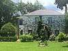 Walker House |
April 10, 2012 (#12000195) |
3534 Miramar Dr. 29°37′09″N 95°00′14″W |
Shoreacres | |
| 27 | Washburn Tunnel | 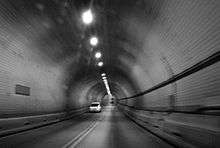 Washburn Tunnel |
April 16, 2008 (#08000316) |
3198 Washburn Tunnel 29°43′35″N 95°12′43″W |
Pasadena | |
| 28 | James M. and Jessie West Mansion | James M. and Jessie West Mansion |
August 19, 1994 (#94001015) |
3303 NASA Rd. 1 29°33′37″N 95°04′28″W |
Pasadena | Demolished in 2019[6][7] |
| 29 | Woodlawn Garden of Memories Cemetery | 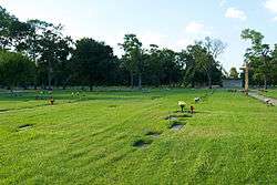 Woodlawn Garden of Memories Cemetery |
October 22, 2004 (#04001174) |
1101 Antoine 29°47′18″N 95°28′41″W |
Houston | |
| 30 | Peter and Sophie Wunderlich Farm | February 27, 1997 (#97000202) |
18202 Theiss Mail Rd. 30°01′49″N 95°32′54″W |
Klein | ||
| 31 | Wunsche Bros. Saloon and Hotel | 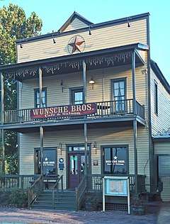 Wunsche Bros. Saloon and Hotel |
February 16, 1984 (#84001849) |
103 Midway St. 30°04′44″N 95°25′03″W |
Spring |
Former listings
| [3] | Name on the Register | Image | Date listed | Date removed | Location | City or town | Summary |
|---|---|---|---|---|---|---|---|
| 1 | Dr. B. J. Covington House | November 15, 1978 (#78002941) | Unknown | 2219 Dowling St. 29°44′24″N 95°21′37″W |
Houston | Dowling Street renamed to Emancipation Avenue in 2017.[8] | |
| 2 | General Mercantile Store | .jpg) General Mercantile Store |
June 4, 1997 (#97000545) | August 18, 2014 | 7322 N. Main St. 29°49′01″N 95°23′33″W |
Houston | |
| 3 | Bill Mraz Dance Hall | March 5, 1998 (#98000219) | December 22, 2004 | 835 W. 34th Street 29°49′00″N 95°24′57″W |
Houston | Destroyed by fire in October 2004[9] |
See also
References
- The latitude and longitude information provided in this table was derived originally from the National Register Information System, which has been found to be fairly accurate for about 99% of listings. Some locations in this table may have been corrected to current GPS standards.
- "National Register of Historic Places: Weekly List Actions". National Park Service, United States Department of the Interior. Retrieved on June 19, 2020.
- Numbers represent an ordering by significant words. Various colorings, defined here, differentiate National Historic Landmarks and historic districts from other NRHP buildings, structures, sites or objects.
- The eight-digit number below each date is the number assigned to each location in the National Register Information System database, which can be viewed by clicking the number.
- Lawrence E. Aten. "Harris County Boys School Site". Texas State Historical Association.
- "Archived copy". Archived from the original on 2016-03-03. Retrieved 2013-08-10.CS1 maint: archived copy as title (link)
External links
| Wikimedia Commons has media related to National Register of Historic Places in Harris County, Texas. |
| Topics | |
|---|---|
| Lists by state |
|
| Lists by insular areas | |
| Lists by associated state | |
| Other areas | |
| Related | |
| |
This article is issued from Wikipedia. The text is licensed under Creative Commons - Attribution - Sharealike. Additional terms may apply for the media files.