National Register of Historic Places listings in San Juan County, Washington
This list presents the full set of buildings, structures, objects, sites, or districts designated on the National Register of Historic Places in San Juan County, Washington, and offers brief descriptive information about each of them. The National Register recognizes places of national, state, or local historic significance across the United States.[1] Out of over 90,000 National Register sites nationwide,[2] Washington is home to approximately 1,500,[3] and 18 of those are found in San Juan County.
- This National Park Service list is complete through NPS recent listings posted June 19, 2020.[4]
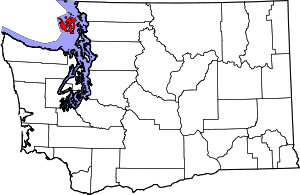
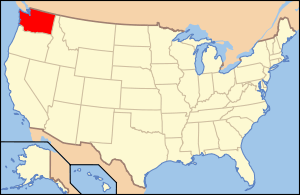
Location of San Juan County in Washington
Current listings
| [5] | Name on the Register | Image | Date listed[6] | Location | City or town | Description |
|---|---|---|---|---|---|---|
| 1 | Alderbrook Farmhouse |  Alderbrook Farmhouse |
November 21, 1985 (#85002919) |
Point Lawrence Rd. 48°39′20″N 122°45′47″W |
Doe Bay | |
| 2 | Crow Valley School |  Crow Valley School |
August 27, 1987 (#87001457) |
Crow Valley Rd. 48°40′04″N 122°56′42″W |
Eastsound | Built in 1888 in Eastsound. Now maintained by the Orcas Island Historical Museum. Rural Public Schools of Washington State MPS |
| 3 | Doe Bay General Store and Post Office |  Doe Bay General Store and Post Office |
May 8, 1986 (#86001017) |
End of County Rd. 48°38′29″N 122°46′45″W |
Doe Bay, Orcas Island | |
| 4 | Michael and Myra Donohue House |  Michael and Myra Donohue House |
January 9, 2013 (#12001161) |
1159 N. Beach Rd. 48°42′20″N 122°54′24″W |
Eastsound | |
| 5 | Emmanuel Episcopal Church | 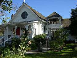 Emmanuel Episcopal Church |
December 12, 1994 (#94001431) |
Main St. 48°41′40″N 122°54′22″W |
Eastsound | Built in 1885. |
| 6 | Krumdiack Homestead | April 29, 1993 (#93000367) |
North coast, between Fishery Pt. and Pt. Hammond 48°43′03″N 123°01′20″W |
Waldron Island | Also known as the Cook Property. | |
| 7 | Little Red Schoolhouse |  Little Red Schoolhouse |
June 19, 1973 (#73001886) |
Corner of Hoffman Cove and Neck Point Cove Rd. 48°34′22″N 122°57′43″W |
Shaw Island | |
| 8 | Moran State Park |  Moran State Park |
January 2, 2013 (#12001140) |
3572 Olga Road 48°38′58″N 122°50′31″W |
Olga | |
| 9 | Orcas Hotel |  Orcas Hotel |
August 24, 1982 (#82004284) |
In Orcas 48°35′54″N 122°56′37″W |
Orcas | Built in 1904. |
| 10 | Patos Island Light Station |  Patos Island Light Station |
October 21, 1977 (#77001355) |
North of Eastsound on Patos Island 48°47′21″N 122°58′11″W |
Eastsound | Built in 1893. |
| 11 | Port Stanley School |  Port Stanley School |
December 9, 1994 (#94001437) |
Port Stanley Rd. 48°31′32″N 122°52′35″W |
Lopez Island | |
| 12 | Roche Harbor |  Roche Harbor |
August 29, 1977 (#77001356) |
Northern San Juan Island 48°36′32″N 123°09′01″W |
San Juan Island | Founded in 1886, the district consists of 1,400 acres (5.7 km2) and 17 buildings. |
| 13 | Rosario | 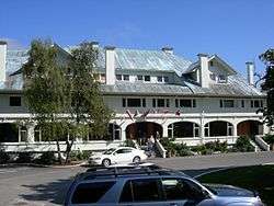 Rosario |
November 2, 1978 (#78002772) |
South of East Sound on Orcas Island 48°38′49″N 122°52′21″W |
Orcas Island | Adjacent to Moran State Park. |
| 14 | San Juan County Courthouse | 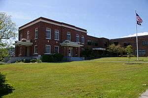 San Juan County Courthouse |
April 12, 1984 (#84003603) |
350 N. Court St. 48°32′09″N 123°01′01″W |
Friday Harbor | Built in 1906. |
| 15 | San Juan Island National Historic Site |  San Juan Island National Historic Site |
October 15, 1966 (#66000369) |
Between Haro Strait and San Juan Channel 48°34′57″N 123°09′01″W |
Friday Harbor | |
| 16 | San Juan Island, Lime Kiln Light Station |  San Juan Island, Lime Kiln Light Station |
December 15, 1978 (#78002771) |
West of Friday Harbor on CR 1 48°30′56″N 123°09′00″W |
Friday Harbor | Built in 1914. |
| 17 | San Juan Lime Company/Cowell's |  San Juan Lime Company/Cowell's |
March 6, 2007 (#07000136) |
1567 West Side Rd. N 48°31′10″N 123°09′05″W |
Friday Harbor | |
| 18 | Tharald Homestead | January 17, 2002 (#01001473) |
Hoffman Cove Rd. 48°33′40″N 122°58′03″W |
Shaw Island | Also known as the Ellis Farm. |
Former listings
| [5] | Name on the Register | Image | Date listed/removed | Location | City or town | Summary | |
|---|---|---|---|---|---|---|---|
| 1 | Richardson General Store and Warehouse | November 21, 1985 (#85002918) | November 14, 1990 | Richardson Rd. |
Richardson |
See also
References
- Andrus, Patrick W.; Shrimpton, Rebecca H.; et al. (2002), How to Apply the National Register Criteria for Evaluation, National Register Bulletin, National Park Service, U.S. Department of the Interior, retrieved June 20, 2014.
- National Park Service, National Register of Historic Places Program: Research, retrieved January 28, 2015.
- Department of Archaeology and Historic Preservation, Washington Information System for Architectural and Archaeological Records Data (WISAARD), retrieved February 14, 2015.
- "National Register of Historic Places: Weekly List Actions". National Park Service, United States Department of the Interior. Retrieved on June 19, 2020.
- Numbers represent an ordering by significant words. Various colorings, defined here, differentiate National Historic Landmarks and historic districts from other NRHP buildings, structures, sites or objects.
- The eight-digit number below each date is the number assigned to each location in the National Register Information System database, which can be viewed by clicking the number.
External links
- Washington Department of Archaeology and Historic Preservation, Historic Register program
- National Park Service, National Register of Historic Places site

| Lists by county |
|  |
|---|---|---|
| Other lists |
| |
| Topics | |
|---|---|
| Lists by state |
|
| Lists by insular areas | |
| Lists by associated state | |
| Other areas | |
| Related | |
| |
Municipalities and communities of San Juan County, Washington, United States | ||
|---|---|---|
| Populated islands | Map of Washington highlighting San Juan County | |
| Town | ||
| Other communities | ||
This article is issued from Wikipedia. The text is licensed under Creative Commons - Attribution - Sharealike. Additional terms may apply for the media files.