National Register of Historic Places listings in Clallam County, Washington
This is a list of the National Register of Historic Places listings in Clallam County, Washington.

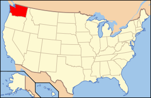
Location of Clallam County in Washington
This is intended to be a complete list of the properties and districts on the National Register of Historic Places in Clallam County, Washington, United States. Latitude and longitude coordinates are provided for many National Register properties and districts; these locations may be seen together in a map.[1]
There are 48 properties and districts listed on the National Register in the county.
- This National Park Service list is complete through NPS recent listings posted June 19, 2020.[2]
Current listings
| [3] | Name on the Register[4] | Image | Date listed[5] | Location | City or town | Description |
|---|---|---|---|---|---|---|
| 1 | Aircraft Warning Service Observation Tower | 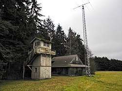 Aircraft Warning Service Observation Tower |
April 29, 1993 (#93000363) |
216 Spring Road 48°06′08″N 123°15′01″W |
Agnew | |
| 2 | Altair Campground Community Kitchen | 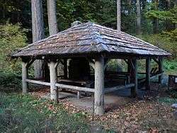 Altair Campground Community Kitchen |
July 13, 2007 (#07000732) |
Along Elwha River, about 3.4 miles (5.5 km) south of Elwha, in Olympic National Park 48°00′41″N 123°35′34″W |
Port Angeles | Possibly damaged by flood in November 2015. |
| 3 | Beaver School |  Beaver School |
November 19, 1992 (#92001591) |
Along US 101, about 1.9 miles (3.1 km) northeast of Beaver 48°03′49″N 124°18′30″W |
Beaver | Included in the Rural Public Schools of Washington State MPS. |
| 4 | Blue Mountain School |  Blue Mountain School |
November 5, 1987 (#87001938) |
1986 Blue Mountain Road, about 8.7 miles (14.0 km) southeast of Port Angeles 48°03′01″N 123°16′29″W |
Port Angeles | |
| 5 | Canyon Creek Shelter |  Canyon Creek Shelter |
July 13, 2007 (#07000712) |
About 0.68 miles (1.09 km) from Sol Duc Trailhead, and about 21.3 miles (34.3 km) southwest of Port Angeles, in Olympic National Park 47°57′08″N 123°49′15″W |
Port Angeles | |
| 6 | Clallam County Courthouse |  Clallam County Courthouse |
September 2, 1987 (#87001459) |
319 Lincoln Street 48°06′57″N 123°26′00″W |
Port Angeles | Also a contributing property to Port Angeles Civic Historic District |
| 7 | Dungeness River Bridge | 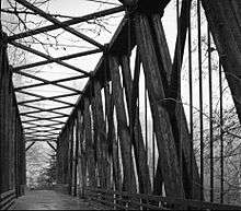 Dungeness River Bridge |
July 16, 1982 (#82004201) |
Spans Dungeness River at Railroad Bridge Park, at end of West Hendrickson Road 48°05′07″N 123°08′52″W |
Sequim | |
| 8 | Dungeness School |  Dungeness School |
May 19, 1988 (#88000627) |
657 Towne Road 48°08′34″N 123°07′42″W |
Dungeness | |
| 9 | Eagle Ranger Station | 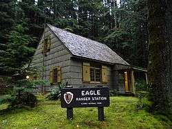 Eagle Ranger Station |
July 13, 2007 (#07000713) |
Along Upper Sol Duc Road, about 22.4 miles (36.0 km) southwest of Port Angeles, in Olympic National Park 47°58′20″N 123°51′52″W |
Port Angeles | |
| 10 | Elkhorn Guard Station | July 13, 2007 (#07000714) |
Along Elwha River Trail, about 14.3 miles (23.0 km) south of Elwha, in Olympic National Forest 47°52′23″N 123°28′10″W |
Port Angeles | ||
| 11 | Elwha Campground Community Kitchen |  Elwha Campground Community Kitchen |
July 13, 2007 (#07000735) |
Along Elwha River, about 2.3 miles (3.7 km) south of Elwha, in Olympic National Park 48°01′40″N 123°35′17″W |
Port Angeles | Possibly damaged by flood in November 2015. |
| 12 | Elwha Ranger Station | 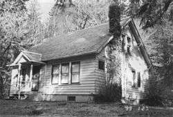 Elwha Ranger Station |
July 13, 2007 (#07000716) |
Along Elwha River, about 3 miles (4.8 km) south of Elwha, in Olympic National Park 48°00′59″N 123°35′26″W |
Port Angeles | |
| 13 | Elwha River Bridge | July 16, 1982 (#82004200) |
Spans Elwha River on Elwha River Road, about 5.6 miles (9.0 km) west of Port Angeles 48°06′50″N 123°33′13″W |
Port Angeles | ||
| 14 | Elwha River Hydroelectric Power Plant | 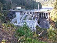 Elwha River Hydroelectric Power Plant |
December 15, 1988 (#88002741) |
On Elwha River, end of Lower Dam Road, about 6 miles (9.7 km) southwest of Port Angeles 48°05′42″N 123°33′24″W |
Port Angeles | Dam demolished in 2014. |
| 15 | Emery Farmstead |  Emery Farmstead |
December 16, 1988 (#88002746) |
At junction of Emery Road and Emery Lane, about 8.5 miles (13.7 km) southeast of Port Angeles 48°04′12″N 123°15′46″W |
Port Angeles | |
| 16 | Fifteen Mile Shelter | July 13, 2007 (#07000715) |
Along North Fork Bogachiel River Trail, about 31 miles (50 km) southwest of Port Angeles, in Olympic National Park 47°54′10″N 124°01′19″W |
Port Angeles | ||
| 17 | Glines Canyon Hydroelectric Power Plant |  Glines Canyon Hydroelectric Power Plant |
December 15, 1988 (#88002742) |
On Elwha River, along Olympic Hot Springs Road, about 11 miles (18 km) southwest of Port Angeles, in Olympic National Park 48°00′07″N 123°36′00″W |
Port Angeles | Dam demolished in 2012. |
| 18 | Hoko River Archeological Site | March 21, 1978 (#78002735) |
Address restricted[6] |
Pysht | ||
| 19 | Hoko River Rockshelter Archeological Site | March 27, 1980 (#80003997) |
Address restricted[6] |
Sekiu | ||
| 20 | Humes Ranch Cabin |  Humes Ranch Cabin |
September 14, 1977 (#77001332) |
On Elwha River, along Geyser Valley trail, about 12.7 miles (20.4 km) southwest of Port Angeles, in Olympic National Park 47°56′59″N 123°32′48″W |
Port Angeles | |
| 21 | Hyak Shelter | July 13, 2007 (#07000721) |
Along North Fork Bogachiel River Trail, about 28.4 miles (45.7 km) southwest of Port Angeles, in Olympic National Park 47°55′22″N 123°58′24″W |
Port Angeles | Included in the Olympic National Park MPS. | |
| 22 | John A. Hyer Farm |  John A. Hyer Farm |
July 29, 1994 (#94000797) |
Address restricted[6] |
Sequim | |
| 23 | Manis Mastodon Site | 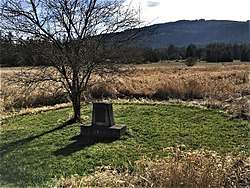 Manis Mastodon Site |
March 21, 1978 (#78002736) |
Address restricted[6] |
Sequim | |
| 24 | Masonic Temple | 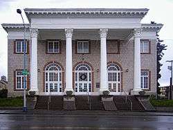 Masonic Temple |
May 11, 1989 (#89000400) |
622 South Lincoln Street 48°06′49″N 123°26′12″W |
Port Angeles | |
| 25 | McAlmond House |  McAlmond House |
August 9, 1976 (#76001879) |
242 Twin View Drive 48°08′48″N 123°08′07″W |
Sequim | |
| 26 | Michael's Cabin | July 13, 2007 (#07000733) |
Along Elwha River Trail, about 7.7 miles (12.4 km) southeast of Elwha, in Olympic National Forest 47°57′11″N 123°33′15″W |
Port Angeles | Included in the Olympic National Park MPS. | |
| 27 | Naval Lodge Elks Building |  Naval Lodge Elks Building |
May 2, 1986 (#86000956) |
131 East First Street 48°07′07″N 123°25′55″W |
Port Angeles | |
| 28 | New Dungeness Light Station | .jpg) New Dungeness Light Station |
November 30, 1993 (#93001338) |
On Dungeness Spit, about 7 miles (11 km) north of Sequim 48°10′54″N 123°06′37″W |
Sequim | |
| 29 | North Fork Sol Duc Shelter | July 13, 2007 (#07000725) |
Along North Fork Sol Duc River Trail, about 17.3 miles (27.8 km) southwest of Port Angeles, in Olympic National Park 47°59′59″N 123°45′48″W |
Port Angeles | ||
| 30 | Olympic National Park Headquarters Historic District |  Olympic National Park Headquarters Historic District |
July 13, 2007 (#07000720) |
600 East Park Avenue 48°05′59″N 123°25′57″W |
Port Angeles | |
| 31 | Ozette Indian Village Archeological Site |  Ozette Indian Village Archeological Site |
January 11, 1974 (#74000916) |
Address restricted[6] |
La Push | |
| 32 | Joseph Paris House |  Joseph Paris House |
November 5, 1987 (#87001939) |
101 East 5th Street 48°06′56″N 123°26′11″W |
Port Angeles | |
| 33 | Port Angeles Civic Historic District |  Port Angeles Civic Historic District |
May 4, 2011 (#11000259) |
207, 215, 217 and 319 South Lincoln Street 48°06′59″N 123°25′59″W |
Port Angeles | Includes former Carnegie Library (1918), former Fire Hall and City Building (1930), Veteran's Memorial Park and former Clallam County Courthouse, which is individually listed on the register. |
| 34 | Pyramid Peak Aircraft Warning Service Lookout | 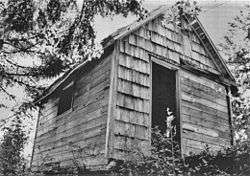 Pyramid Peak Aircraft Warning Service Lookout |
July 13, 2007 (#07000726) |
End of Pyramid Peak Trail, about 17.6 miles (28.3 km) west of Port Angeles, Washington, in Olympic National Park 48°04′28″N 123°48′28″W |
Port Angeles | |
| 35 | Peter Roose Homestead | .JPG) Peter Roose Homestead |
July 13, 2007 (#07000723) |
About 0.4 miles (0.64 km) north of Cape Alava Trail, 1.9 miles (3.1 km) west of Ozette, in Olympic National Park 48°09′42″N 124°42′25″W |
Port Angeles | |
| 36 | Rosemary Inn | 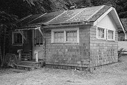 Rosemary Inn |
July 17, 1979 (#79001033) |
East of Barnes Point, on south shore of Lake Crescent, about 17.2 miles (27.7 km) southwest of Port Angeles, in Olympic National Park 48°03′35″N 123°47′39″W |
Port Angeles | |
| 37 | Sekiu School |  Sekiu School |
May 1, 1991 (#91000539) |
42 Rice Street 48°15′47″N 124°18′08″W |
Sekiu | Included in the Rural Public Schools of Washington State MPS |
| 38 | Sequim Opera House |  Sequim Opera House |
May 28, 1991 (#91000632) |
119 North Sequim Avenue 48°04′48″N 123°06′09″W |
Sequim | |
| 39 | Singer's Lake Crescent Tavern |  Singer's Lake Crescent Tavern |
July 13, 2007 (#07000724) |
South of Barnes Point, on south shore of Lake Crescent, about 17.4 miles (28.0 km) southwest of Port Angeles, in Olympic National Park 48°03′26″N 123°47′57″W |
Port Angeles | |
| 40 | St. Andrew's Episcopal Church | .jpg) St. Andrew's Episcopal Church |
November 5, 1987 (#87001942) |
206 South Peabody Street 48°06′57″N 123°25′46″W |
Port Angeles | |
| 41 | Storm King Ranger Station | 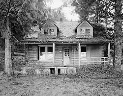 Storm King Ranger Station |
July 13, 2007 (#07000730) |
Southeast of Barnes Point, on south shore of Lake Crescent, about 17 miles (27 km) southwest of Port Angeles, in Olympic National Park 48°03′28″N 123°47′19″W |
Port Angeles | |
| 42 | Tatoosh Island | 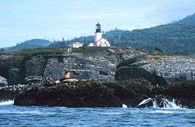 Tatoosh Island |
March 16, 1972 (#72001267) |
Off Cape Flattery 48°23′31″N 124°44′10″W |
Olympic Peninsula | |
| 43 | Three Forks Shelter | July 13, 2007 (#07000728) |
At confluence of Grand Creek and Cameron Creek, along Three Forks Trail, about 13.2 miles (21.2 km) southwest of Sequim, in Olympic National Park 47°54′56″N 123°14′52″W |
Sequim | Included in the Olympic National Park MPS. | |
| 44 | Tse whit zen Village |  Tse whit zen Village |
October 8, 2014 (#14000848) |
Address restricted[6] |
Port Angeles | |
| 45 | U.S. Post Office | 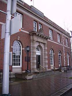 U.S. Post Office |
September 1, 1983 (#83003321) |
138 West 1st Street 48°07′10″N 123°26′07″W |
Port Angeles | |
| 46 | US Quarantine Station Surgeon's Residence |  US Quarantine Station Surgeon's Residence |
May 11, 1989 (#89000401) |
101 Discovery Way, Diamond Point 48°05′37″N 122°55′13″W |
Sequim | |
| 47 | Wedding Rock Petroglyphs | 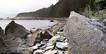 Wedding Rock Petroglyphs |
April 3, 1976 (#76000951) |
Address restricted[6] |
Forks | |
| 48 | Wendel Property | July 13, 2007 (#07000739) |
3723 East Beach Road, 0.5 miles (0.80 km) west of Piedmont, about 17.2 miles (27.7 km) west of Port Angeles, in Olympic National Park 48°05′41″N 123°48′07″W |
Port Angeles |
See also
| Wikimedia Commons has media related to National Register of Historic Places in Clallam County, Washington. |
- National Register of Historic Places listings in Washington state
- List of National Historic Landmarks in Washington
References
- The latitude and longitude information provided in this table was derived originally from the National Register Information System, which has been found to be fairly accurate for about 99% of listings. Some locations in this table may have been corrected to current GPS standards.
- "National Register of Historic Places: Weekly List Actions". National Park Service, United States Department of the Interior. Retrieved on June 19, 2020.
- Numbers represent an ordering by significant words. Various colorings, defined here, differentiate National Historic Landmarks and historic districts from other NRHP buildings, structures, sites or objects.
- "National Register Information System". National Register of Historic Places. National Park Service. April 24, 2008.
- The eight-digit number below each date is the number assigned to each location in the National Register Information System database, which can be viewed by clicking the number.
- Federal and state laws and practices restrict general public access to information regarding the specific location of this resource. In some cases, this is to protect archeological sites from vandalism, while in other cases it is restricted at the request of the owner. See: Knoerl, John; Miller, Diane; Shrimpton, Rebecca H. (1990), Guidelines for Restricting Information about Historic and Prehistoric Resources, National Register Bulletin, National Park Service, U.S. Department of the Interior, OCLC 20706997.
| Lists by county |
|  |
|---|---|---|
| Other lists |
| |
| Topics | |
|---|---|
| Lists by state |
|
| Lists by insular areas | |
| Lists by associated state | |
| Other areas | |
| Related | |
| |
Municipalities and communities of Clallam County, Washington, United States | ||
|---|---|---|
| Cities | Map of Washington highlighting Clallam County | |
| CDPs | ||
| Other unincorporated communities | ||
| Indian reservations | ||
| Ghost towns | ||
This article is issued from Wikipedia. The text is licensed under Creative Commons - Attribution - Sharealike. Additional terms may apply for the media files.