National Register of Historic Places listings in Pacific County, Washington
This list presents the full set of buildings, structures, objects, sites, or districts designated on the National Register of Historic Places in Pacific County, Washington, and offers brief descriptive information about each of them. The National Register recognizes places of national, state, or local historic significance across the United States.[1] Out of over 90,000 National Register sites nationwide,[2] Washington is home to approximately 1,500,[3] and 19 of those are found in Pacific County.
- This National Park Service list is complete through NPS recent listings posted June 26, 2020.[4]
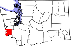
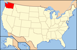
Location of Pacific County in Washington
Current listings
| [5] | Name on the Register | Image | Date listed[6] | Location | City or town | Description |
|---|---|---|---|---|---|---|
| 1 | Cape Disappointment Historic District |  Cape Disappointment Historic District |
August 15, 1975 (#75001864) |
From .5 mi (0.80 km). S of Ilwaco to WA/OR boundary 46°17′01″N 124°03′37″W |
Ilwaco | |
| 2 | Chinook Point | 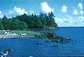 Chinook Point |
October 15, 1966 (#66000747) |
5 mi (8.0 km). SE of Fort Columbia Historical State Park on U.S. 101 46°15′25″N 123°54′57″W |
Chinook | |
| 3 | Colbert House |  Colbert House |
October 18, 1977 (#77001347) |
Quaker and Lake Sts. 46°18′31″N 124°02′06″W |
Ilwaco | |
| 4 | Columbia River Quarantine Station |  Columbia River Quarantine Station |
February 8, 1980 (#80004007) |
SW of Knappton on WA 401 46°16′15″N 123°49′47″W |
Knappton | |
| 5 | Klipsan Beach Life Saving Station | 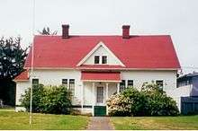 Klipsan Beach Life Saving Station |
July 5, 1979 (#79002546) |
WA 103 46°27′53″N 124°03′09″W |
Klipsan Beach | |
| 6 | Lumber Exchange Building |  Lumber Exchange Building |
May 19, 1988 (#88000604) |
Robert Bush Dr./US 101 and Willapa Ave. 46°39′58″N 123°48′42″W |
South Bend | Demolished |
| 7 | Oysterville Historic District |  Oysterville Historic District |
April 21, 1976 (#76001898) |
WA 103 46°32′46″N 124°01′44″W |
Oysterville | |
| 8 | Pacific County Courthouse |  Pacific County Courthouse |
July 20, 1977 (#77001348) |
Cowlitz and Vine Sts. 46°39′46″N 123°48′33″W |
South Bend | |
| 9 | Raymond Public Library |  Raymond Public Library |
November 29, 1979 (#79002548) |
507 Duryea St. 46°41′12″N 123°43′50″W |
Raymond | |
| 10 | Raymond Theater |  Raymond Theater |
May 1, 1991 (#91000540) |
325 N. Third St. 46°41′10″N 123°44′00″W |
Raymond | |
| 11 | Russell House |  Russell House |
November 25, 1977 (#77001349) |
902 E. Water St. 46°39′46″N 123°46′59″W |
South Bend | |
| 12 | Peter Schulderman House |  Peter Schulderman House |
May 19, 1988 (#88000597) |
37th St. and K Pl. 46°19′45″N 124°03′25″W |
Seaview | |
| 13 | Shelburne Hotel |  Shelburne Hotel |
December 15, 1978 (#78002765) |
WA 103 and K St. 46°20′06″N 124°03′14″W |
Seaview | |
| 14 | Shogren Cottage | April 8, 2019 (#100002409) |
22107 Pacific Way 46°27′45″N 124°03′12″W |
Ocean Park | ||
| 15 | South Bend Carnegie Public Library |  South Bend Carnegie Public Library |
August 3, 1982 (#82004269) |
W. 1st and Pacific Sts. 46°39′59″N 123°48′51″W |
South Bend | Carnegie Libraries of Washington TR |
| 16 | Tokeland Hotel | 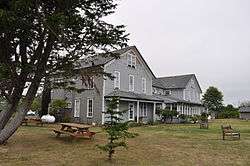 Tokeland Hotel |
April 11, 1978 (#78002766) |
Kindred Ave. and Hotel Rd. 46°42′31″N 123°59′00″W |
Tokeland | |
| 17 | U.S. Post Office – Raymond Main |  U.S. Post Office – Raymond Main |
May 30, 1991 (#91000654) |
406 Duryea St. 46°41′11″N 123°43′55″W |
Raymond | |
| 18 | Willapa Bay Boathouse |  Willapa Bay Boathouse |
March 13, 1986 (#86000358) |
US Coast Guard Station, Willapa Bay 46°42′21″N 123°58′01″W |
Tokeland | |
| 19 | The Wreckage | 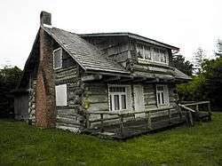 The Wreckage |
September 18, 1979 (#79002547) |
256th Pl. 46°29′15″N 124°03′03″W |
Ocean Park | Log house |
See also
References
- Andrus, Patrick W.; Shrimpton, Rebecca H.; et al. (2002), How to Apply the National Register Criteria for Evaluation, National Register Bulletin, National Park Service, U.S. Department of the Interior, retrieved June 20, 2014.
- National Park Service, National Register of Historic Places Program: Research, retrieved January 28, 2015.
- Department of Archaeology and Historic Preservation, Washington Information System for Architectural and Archaeological Records Data (WISAARD), retrieved February 14, 2015.
- "National Register of Historic Places: Weekly List Actions". National Park Service, United States Department of the Interior. Retrieved on June 26, 2020.
- Numbers represent an ordering by significant words. Various colorings, defined here, differentiate National Historic Landmarks and historic districts from other NRHP buildings, structures, sites or objects.
- The eight-digit number below each date is the number assigned to each location in the National Register Information System database, which can be viewed by clicking the number.
External links
- Washington Department of Archaeology and Historic Preservation, Historic Register program
- National Park Service, National Register of Historic Places site

| Lists by county |
|  |
|---|---|---|
| Other lists |
| |
| Topics | |
|---|---|
| Lists by state |
|
| Lists by insular areas | |
| Lists by associated state | |
| Other areas | |
| Related | |
| |
Municipalities and communities of Pacific County, Washington, United States | ||
|---|---|---|
| Cities | Map of Washington highlighting Pacific County | |
| CDPs | ||
| Other unincorporated communities | ||
| Ghost towns | ||
| Indian reservation | ||
This article is issued from Wikipedia. The text is licensed under Creative Commons - Attribution - Sharealike. Additional terms may apply for the media files.