National Register of Historic Places listings in Lake County, Colorado
This is a list of the National Register of Historic Places listings in Lake County, Colorado.
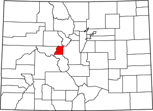
Location of Lake County in Colorado
This is intended to be a complete list of the properties and districts on the National Register of Historic Places in Lake County, Colorado, United States. The locations of National Register properties and districts for which the latitude and longitude coordinates are included below, may be seen in an online map.
There are 9 properties and districts listed on the National Register in the county.
- This National Park Service list is complete through NPS recent listings posted June 19, 2020.[1]
| Adams - Alamosa - Arapahoe - Archuleta - Baca - Bent - Boulder - Broomfield - Chaffee - Cheyenne - Clear Creek - Conejos - Costilla - Crowley - Custer - Delta - Denver - Dolores - Douglas - Eagle - El Paso - Elbert - Fremont - Garfield - Gilpin - Grand - Gunnison - Hinsdale - Huerfano - Jackson - Jefferson - Kiowa - Kit Carson - La Plata - Lake - Larimer - Las Animas - Lincoln - Logan - Mesa - Mineral - Moffat - Montezuma - Montrose - Morgan - Otero - Ouray - Park - Phillips - Pitkin - Prowers - Pueblo - Rio Blanco - Rio Grande - Routt - Saguache - San Juan - San Miguel - Sedgwick - Summit - Teller - Washington - Weld - Yuma |
Current listings
| [2] | Name on the Register[3] | Image | Date listed[4] | Location | City or town | Description |
|---|---|---|---|---|---|---|
| 1 | Derry Mining Site Camp | 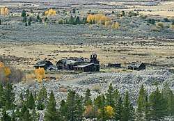 Derry Mining Site Camp |
July 14, 2000 (#00000782) |
West of U.S. Highway 24 39°07′24″N 106°20′37″W |
Leadville | |
| 2 | Dexter Cabin | 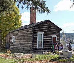 Dexter Cabin |
August 25, 1970 (#70000163) |
912 Harrison Ave. 39°15′07″N 106°17′17″W |
Leadville | |
| 3 | Hayden Ranch Headquarters | Hayden Ranch Headquarters |
October 11, 2003 (#03001007) |
West of U.S. Highway 24 39°07′41″N 106°18′55″W |
Leadville | |
| 4 | Healy House | 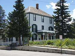 Healy House |
August 25, 1970 (#70000164) |
912 Harrison Ave. 39°15′08″N 106°17′18″W |
Leadville | |
| 5 | Interlaken Resort District | 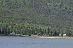 Interlaken Resort District |
August 7, 1974 (#74000587) |
East of Twin Lakes off State Highway 82 39°04′39″N 106°20′49″W |
Twin Lakes | Located across the Twin Lakes from Colorado Route 82; public access only via hiking trail. |
| 6 | Leadville Historic District | 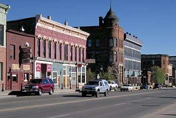 Leadville Historic District |
October 15, 1966 (#66000248) |
Town of Leadville 39°14′39″N 106°13′42″W |
Leadville | |
| 7 | Leadville National Fish Hatchery | 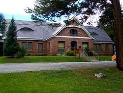 Leadville National Fish Hatchery |
May 29, 1980 (#80000908) |
West of Leadville 39°13′31″N 106°23′32″W |
Leadville | |
| 8 | Matchless Mine | 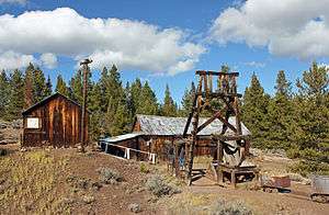 Matchless Mine |
December 28, 2010 (#10001088) |
East 7th Road 39°15′22″N 106°16′16″W |
Leadville | (Mining Industry in Colorado, MPS) |
| 9 | Twin Lakes District | 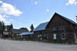 Twin Lakes District |
July 30, 1974 (#74000588) |
Both sides of State Highway 82 39°04′56″N 106°22′56″W |
Twin Lakes |
See also
| Wikimedia Commons has media related to National Register of Historic Places in Lake County, Colorado. |
References
- "National Register of Historic Places: Weekly List Actions". National Park Service, United States Department of the Interior. Retrieved on June 19, 2020.
- Numbers represent an ordering by significant words. Various colorings, defined here, differentiate National Historic Landmarks and historic districts from other NRHP buildings, structures, sites or objects.
- "National Register Information System". National Register of Historic Places. National Park Service. July 9, 2010.
- The eight-digit number below each date is the number assigned to each location in the National Register Information System database, which can be viewed by clicking the number.
| Topics | |
|---|---|
| Lists by state |
|
| Lists by insular areas | |
| Lists by associated state | |
| Other areas | |
| Related | |
| |
Municipalities and communities of Lake County, Colorado, United States | ||
|---|---|---|
| City | Map of Colorado highlighting Lake County | |
| CDPs | ||
| Ghost towns | ||
This article is issued from Wikipedia. The text is licensed under Creative Commons - Attribution - Sharealike. Additional terms may apply for the media files.