National Register of Historic Places listings in Douglas County, Colorado
This is a list of the National Register of Historic Places listings in Douglas County, Colorado.

Location of Douglas County in Colorado
This is intended to be a complete list of the properties and districts on the National Register of Historic Places in Douglas County, Colorado, United States. The locations of National Register properties and districts for which the latitude and longitude coordinates are included below, may be seen in a map.[1]
There are 29 properties and districts listed on the National Register in the county. Another property was once listed but has been removed.
- This National Park Service list is complete through NPS recent listings posted June 19, 2020.[2]
| Adams - Alamosa - Arapahoe - Archuleta - Baca - Bent - Boulder - Broomfield - Chaffee - Cheyenne - Clear Creek - Conejos - Costilla - Crowley - Custer - Delta - Denver - Dolores - Douglas - Eagle - El Paso - Elbert - Fremont - Garfield - Gilpin - Grand - Gunnison - Hinsdale - Huerfano - Jackson - Jefferson - Kiowa - Kit Carson - La Plata - Lake - Larimer - Las Animas - Lincoln - Logan - Mesa - Mineral - Moffat - Montezuma - Montrose - Morgan - Otero - Ouray - Park - Phillips - Pitkin - Prowers - Pueblo - Rio Blanco - Rio Grande - Routt - Saguache - San Juan - San Miguel - Sedgwick - Summit - Teller - Washington - Weld - Yuma |
Current listings
| [3] | Name on the Register[4] | Image | Date listed[5] | Location | City or town | Description |
|---|---|---|---|---|---|---|
| 1 | American Federation of Human Rights Headquarters | 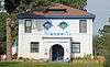 American Federation of Human Rights Headquarters |
March 19, 1998 (#98000247) |
9070 S. Douglas Boulevard 39°13′44″N 104°53′15″W |
Larkspur | |
| 2 | Bayou Gulch | April 13, 2020 (#100005167) |
Address Restricted |
Franktown vicinity | ||
| 3 | Bear Canon Agricultural District | 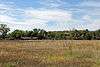 Bear Canon Agricultural District |
October 29, 1975 (#75000517) |
South of Denver on both sides of State Highway 105 from State Highway 67 south to Jarre Creek 39°23′46″N 104°57′41″W |
Sedalia | |
| 4 | Castle Rock Depot | 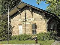 Castle Rock Depot |
October 11, 1974 (#74000575) |
420 Elbert St. 39°22′27″N 104°51′43″W |
Castle Rock | |
| 5 | Castle Rock Elementary School |  Castle Rock Elementary School |
September 20, 1984 (#84000827) |
3rd and Cantril Sts. 39°22′22″N 104°51′19″W |
Castle Rock | |
| 6 | Cherokee Ranch | 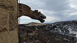 Cherokee Ranch |
October 21, 1994 (#94001228) |
North of County Road 85 and south of Daniels Park Rd. 39°27′20″N 104°55′36″W |
Sedalia | 3,280 acres (13.3 km2) ranch including a replica of a 15th century Scottish castle |
| 7 | Cherry Creek Bridge | 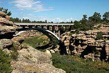 Cherry Creek Bridge |
October 15, 2002 (#02001147) |
State Highway 83 at milepost 46.30 39°19′52″N 104°44′02″W |
Franktown | |
| 8 | Church of St. Philip-in-the-Field and Bear Canon Cemetery | 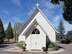 Church of St. Philip-in-the-Field and Bear Canon Cemetery |
April 11, 1973 (#73000471) |
5 miles (8.0 km) south of Sedalia on State Highway 105 39°22′05″N 104°57′33″W |
Sedalia | |
| 9 | Daniels Park | .JPG) Daniels Park |
June 30, 1995 (#95000795) |
Along Douglas County Road 67 northeast of Sedalia 39°28′50″N 104°55′37″W |
Sedalia | |
| 10 | Devils Head Lookout | 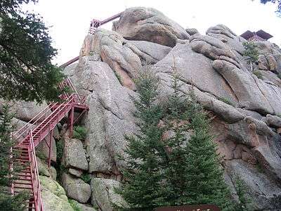 Devils Head Lookout |
June 13, 2003 (#03000518) |
South Platte District in the Pike National Forest 39°15′37″N 105°06′03″W |
Sedalia | |
| 11 | Samuel Dyer House | 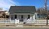 Samuel Dyer House |
December 13, 2016 (#16000836) |
208 North Cantril St. 39°22′18″N 104°51′22″W |
Castle Rock | |
| 12 | Evans Homestead Rural Historic Landscape | April 25, 2012 (#12000226) |
Address Restricted |
Franktown | ||
| 13 | First National Bank of Douglas County | 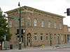 First National Bank of Douglas County |
April 14, 1995 (#95000440) |
300 Wilcox St. 39°22′21″N 104°51′33″W |
Castle Rock | |
| 14 | Franktown Cave | February 1, 2006 (#05001561) |
Address Restricted |
Franktown | ||
| 15 | Glen Grove School | 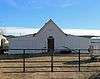 Glen Grove School |
November 5, 1974 (#74000576) |
North of Palmer Lake off Perry Park Rd. 39°15′38″N 104°57′02″W |
Palmer Lake | Re-purposed as a barn. |
| 16 | Benjamin Hammar House | 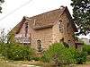 Benjamin Hammar House |
February 3, 1993 (#92001847) |
203 Cantril St. 39°22′18″N 104°51′22″W |
Castle Rock | |
| 17 | Indian Park School | 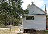 Indian Park School |
February 8, 1978 (#78000857) |
10 miles (16 km) west of Sedalia on State Highway 67 39°22′49″N 105°04′52″W |
Sedalia | |
| 18 | Keystone Hotel | 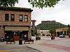 Keystone Hotel |
June 20, 1997 (#97000594) |
219 and 223 4th St. 39°22′25″N 104°51′36″W |
Castle Rock | |
| 19 | John Kinner House | 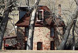 John Kinner House |
October 11, 1974 (#74000578) |
6694 Perry Park Rd. 39°16′19″N 104°57′27″W |
Sedalia | House built in 1896 of sandstone quarried by John Kinner. |
| 20 | Lamb Spring | 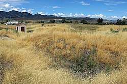 Lamb Spring |
March 13, 1997 (#97000208) |
Address Restricted |
Littleton | |
| 21 | Louviers Village |  Louviers Village |
July 2, 1999 (#99000710) |
Louviers Boulevard, Hillcrest Dr., Triangle Dr., Main St., Valley View St., and 1st, 2nd, 3rd and 4th Sts. 39°28′36″N 105°00′22″W |
Louviers | |
| 22 | Louviers Village Club | 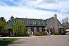 Louviers Village Club |
September 22, 1995 (#95001117) |
Junction of Louviers Boulevard and 1st St. 39°28′34″N 105°00′23″W |
Louviers | |
| 23 | Pike's Peak Grange No. 163 | 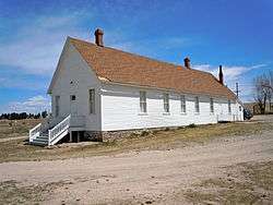 Pike's Peak Grange No. 163 |
October 1, 1990 (#90001502) |
3093 State Highway 83 39°24′32″N 104°45′42″W |
Franktown | |
| 24 | Ben Quick Ranch and Fort |  Ben Quick Ranch and Fort |
October 1, 1974 (#74000577) |
6695 W. Plum Creek Rd. 39°15′52″N 104°57′10″W |
Palmer Lake | |
| 25 | Roxborough State Park Archaeological District | .jpg) Roxborough State Park Archaeological District |
January 27, 1983 (#83001316) |
Address Restricted |
Waterton | |
| 26 | Ruth Memorial Methodist Episcopal Church | 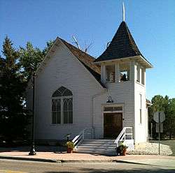 Ruth Memorial Methodist Episcopal Church |
May 1, 1989 (#89000332) |
19670 E. Mainstreet 39°31′05″N 104°45′34″W |
Parker | |
| 27 | Santa Fe Railway Water Tank | 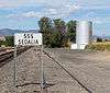 Santa Fe Railway Water Tank |
April 18, 2003 (#03000237) |
U.S. Route 85 west of its junction with State Highway 67 39°26′22″N 104°57′50″W |
Sedalia | |
| 28 | Reginald Sinclaire House | 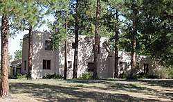 Reginald Sinclaire House |
September 20, 1991 (#91001418) |
6154 Perry Park Rd. 39°16′20″N 104°56′39″W |
Larkspur | Home of Reginald Sinclaire, in Colorado Aviation Hall of Fame |
| 29 | Spring Valley School | .JPG) Spring Valley School |
December 18, 1978 (#78000856) |
East of Larkspur at Spring Valley and Lorraine Rds. 39°09′08″N 104°46′10″W |
Larkspur |
Former listing
| [3] | Name on the Register | Image | Date listed | Date removed | Location | City or town | Summary |
|---|---|---|---|---|---|---|---|
| 1 | Douglas County Courthouse | December 12, 1976 (#76000558) | 1978 | 301 Wilcox St. |
Castle Rock | Destroyed by fire March 11, 1978 |
See also
| Wikimedia Commons has media related to National Register of Historic Places in Douglas County, Colorado. |
References
- The latitude and longitude information provided in this table was derived originally from the National Register Information System, which has been found to be fairly accurate for about 99% of listings. Some locations in this table may have been corrected to current GPS standards.
- "National Register of Historic Places: Weekly List Actions". National Park Service, United States Department of the Interior. Retrieved on June 19, 2020.
- Numbers represent an ordering by significant words. Various colorings, defined here, differentiate National Historic Landmarks and historic districts from other NRHP buildings, structures, sites or objects.
- "National Register Information System". National Register of Historic Places. National Park Service. July 9, 2010.
- The eight-digit number below each date is the number assigned to each location in the National Register Information System database, which can be viewed by clicking the number.
| Topics | |
|---|---|
| Lists by state |
|
| Lists by insular areas | |
| Lists by associated state | |
| Other areas | |
| Related | |
| |
Municipalities and communities of Douglas County, Colorado, United States | ||
|---|---|---|
| Cities | Map of Colorado highlighting Douglas County | |
| Towns | ||
| CDPs |
| |
| Unincorporated communities |
| |
| Footnotes | ‡This populated place also has portions in an adjacent county or counties | |
This article is issued from Wikipedia. The text is licensed under Creative Commons - Attribution - Sharealike. Additional terms may apply for the media files.