National Register of Historic Places listings in Fremont County, Wyoming
This is a list of the National Register of Historic Places listings in Fremont County, Wyoming.
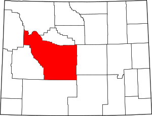
Location of Fremont County in Wyoming
This is intended to be a complete list of the properties and districts on the National Register of Historic Places in Fremont County, Wyoming, United States. The locations of National Register properties and districts for which the latitude and longitude coordinates are included below, may be seen in a map.[1]
There are 35 properties and districts listed on the National Register in the county, 1 of which is a National Historic Landmark.
- This National Park Service list is complete through NPS recent listings posted June 19, 2020.[2]
| Albany - Big Horn - Campbell - Carbon - Converse - Crook - Fremont - Goshen - Hot Springs - Johnson - Laramie - Lincoln - Natrona - Niobrara - Park - Platte - Sheridan - Sublette - Sweetwater - Teton - Uinta - Washakie - Weston |
Current listings
| [3] | Name on the Register | Image | Date listed[4] | Location | City or town | Description |
|---|---|---|---|---|---|---|
| 1 | Amoretti, Welty, Helmer & Co Bank | September 27, 2019 (#100004423) |
111 W. Ramshorn St. 43°32′01″N 109°38′01″W |
Dubois | ||
| 2 | Atlantic City Mercantile | 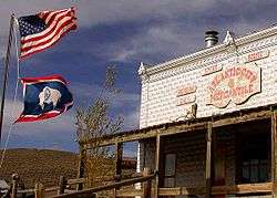 Atlantic City Mercantile |
April 25, 1985 (#85000869) |
Rt. 62, Box 260 42°29′15″N 108°43′47″W |
Atlantic City | |
| 3 | BMU Bridge over Wind River | 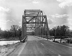 BMU Bridge over Wind River |
February 22, 1985 (#85000421) |
Wyoming Highway 132 43°08′36″N 108°42′29″W |
Ethete | Replaced |
| 4 | Brooks Lake Lodge | September 29, 1982 (#82004333) |
Lower Brooks Lake-Shoshone National Forest 43°44′47″N 110°00′23″W |
Dubois | Partially damaged by fire July 28, 2019. | |
| 5 | Carpenter Hotel Historic District | 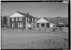 Carpenter Hotel Historic District |
December 12, 2012 (#12001054) |
290 Atlantic City Rd. 42°29′40″N 108°43′59″W |
Atlantic City | |
| 6 | Castle Gardens Petroglyph Site | 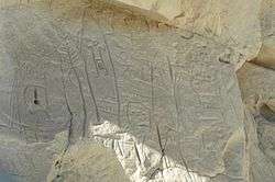 Castle Gardens Petroglyph Site |
April 16, 1969 (#69000189) |
Castle Garden Road 42°55′45″N 107°36′49″W |
Moneta | |
| 7 | CM Ranch and Simpson Lake Cabins | September 15, 1992 (#92001249) |
State Fish Hatchery Rd. south of Dubois off U.S. Route 287 43°28′08″N 109°39′03″W |
Dubois | ||
| 8 | Dean Decker Site (48FR916; 48SW541) |  Dean Decker Site (48FR916; 48SW541) |
March 12, 1986 (#86000354) |
Address restricted |
Honeycomb Buttes | Extends into Sweetwater County |
| 9 | Delfelder Schoolhouse | March 29, 1978 (#78002826) |
North of Riverton off U.S. Route 26 43°05′01″N 108°21′37″W |
Riverton | ||
| 10 | Diamond A Ranch | August 19, 1991 (#91001026) |
Off U.S. Routes 26/287 northeast of Whiskey Mountain 43°28′43″N 109°30′09″W |
Dubois | ||
| 11 | ELS Bridge over Big Wind River | 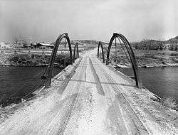 ELS Bridge over Big Wind River |
February 22, 1985 (#85000420) |
County Road CN10-21 43°32′47″N 109°40′02″W |
Dubois | Has been replaced |
| 12 | ELY Wind River Diversion Dam Bridge | 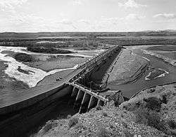 ELY Wind River Diversion Dam Bridge |
February 22, 1985 (#85000422) |
County Road CN10-24 43°13′30″N 108°57′16″W |
Morton | |
| 13 | Fort Washakie Historic District | 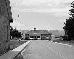 Fort Washakie Historic District |
April 16, 1969 (#69000188) |
Wind River Indian Reservation on U.S. Route 287 43°00′22″N 108°52′59″W |
Fort Washakie | |
| 14 | Green Mountain Arrow Site | Green Mountain Arrow Site |
March 12, 1986 (#86000351) |
Address Restricted |
Stratton Rim | |
| 15 | Hamilton City | 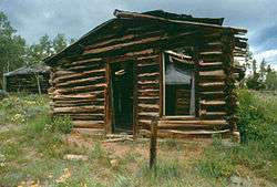 Hamilton City |
June 4, 1980 (#80004047) |
Northeast of Atlantic City 42°31′58″N 108°40′55″W |
Atlantic City | |
| 16 | High Rise Village | High Rise Village |
July 23, 2013 (#13000542) |
Address Restricted |
Dubois vicinity | |
| 17 | Jackson Park Town Site Addition Brick Row | 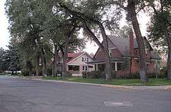 Jackson Park Town Site Addition Brick Row |
February 27, 2003 (#03000083) |
615, 635, and 677 S. 3rd St. 42°49′39″N 108°43′58″W |
Lander | |
| 18 | C. H. King Company and First National Bank of Shoshoni | 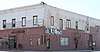 C. H. King Company and First National Bank of Shoshoni |
September 8, 1994 (#94001135) |
127 Main St. 43°14′06″N 108°06′25″W |
Shoshoni | Also known as Old Yellowstone Drug |
| 19 | Lander Downtown Historic District | Lander Downtown Historic District |
May 5, 1987 (#87000700) |
Main St. between 2nd and 4th Sts. 42°49′59″N 108°43′55″W |
Lander | |
| 20 | Helen Lookingbill Site | Helen Lookingbill Site |
March 20, 2013 (#13000102) |
Address Restricted |
Dubois | |
| 21 | Quien Sabe Ranch | April 18, 1991 (#91000434) |
Quien Sabe Ranch Rd., 18 mi (29 km) northeast of Shoshoni 43°23′40″N 107°59′35″W |
Shoshoni | ||
| 22 | Riverton Railroad Depot | 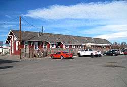 Riverton Railroad Depot |
May 22, 1978 (#78002827) |
1st and Main Sts. 43°01′28″N 108°23′24″W |
Riverton | |
| 23 | Shoshone-Episcopal Mission | Shoshone-Episcopal Mission |
April 11, 1973 (#73001931) |
3 mi (4.8 km) southwest of Fort Washakie on Moccasin Lake Rd. 42°59′09″N 108°54′17″W |
Fort Washakie | Destroyed by fire in 2016[5] |
| 24 | South Pass |  South Pass |
October 15, 1966 (#66000754) |
About 10 mi (16 km) southwest of South Pass City on Wyoming Highway 28 42°22′12″N 108°54′49″W |
South Pass City | |
| 25 | South Pass City Historic District | 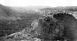 South Pass City Historic District |
February 26, 1970 (#70000670) |
South Pass Rd.; also 675 Atlantic City Rd. 42°28′16″N 108°48′19″W |
South Pass City | Originally listed simply as "South Pass City"; name changed in 2012 |
| 26 | Split Rock Prehistoric Site | Split Rock Prehistoric Site |
May 4, 1987 (#87000662) |
Address Restricted |
Split Rock Ranch | |
| 27 | St. Michael's Mission | 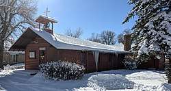 St. Michael's Mission |
June 21, 1971 (#71000886) |
In Ethete 43°01′30″N 108°46′22″W |
Ethete | |
| 28 | T Cross Ranch Rural Historic District | T Cross Ranch Rural Historic District |
April 11, 2008 (#07000371) |
Address Restricted |
Dubois | |
| 29 | Torrey Lake Club/Ranch Historic District | 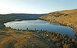 Torrey Lake Club/Ranch Historic District |
August 12, 1991 (#91000999) |
Along the western shores of Lake Julia, Torrey Lake, and Ring Lake 43°27′38″N 109°33′21″W |
Dubois | |
| 30 | Torrey Lake Petroglyph District | .jpg) Torrey Lake Petroglyph District |
October 4, 1993 (#93000983) |
Address Restricted |
Dubois | |
| 31 | Twin Pines Lodge and Cabin Camp | 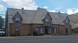 Twin Pines Lodge and Cabin Camp |
December 10, 1993 (#93001382) |
218 W. Ramshorn 43°32′01″N 109°38′04″W |
Dubois | |
| 32 | Union Pass |  Union Pass |
April 16, 1969 (#69000367) |
On the Continental Divide in Teton National Forest 43°28′54″N 109°52′24″W |
Dubois | |
| 33 | US Post Office and Courthouse-Lander Main | .JPG) US Post Office and Courthouse-Lander Main |
May 19, 1987 (#87000782) |
177 N. 3rd St. 42°50′02″N 108°43′50″W |
Lander | |
| 34 | Welty's General Store | 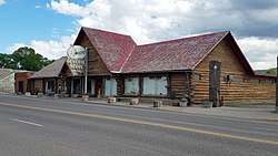 Welty's General Store |
November 15, 1979 (#79003680) |
220 Ramshorn St. 43°32′01″N 109°37′59″W |
Dubois | |
| 35 | Wind River Agency Blockhouse | Wind River Agency Blockhouse |
December 23, 2000 (#00001589) |
Address Restricted |
Fort Washakie |
See also
References
| Wikimedia Commons has media related to National Register of Historic Places in Fremont County, Wyoming. |
- The latitude and longitude information provided in this table was derived originally from the National Register Information System, which has been found to be fairly accurate for about 99% of listings. Some locations in this table may have been corrected to current GPS standards.
- "National Register of Historic Places: Weekly List Actions". National Park Service, United States Department of the Interior. Retrieved on June 19, 2020.
- Numbers represent an ordering by significant words. Various colorings, defined here, differentiate National Historic Landmarks and historic districts from other NRHP buildings, structures, sites or objects.
- The eight-digit number below each date is the number assigned to each location in the National Register Information System database, which can be viewed by clicking the number.
Municipalities and communities of Fremont County, Wyoming, United States | ||
|---|---|---|
| Cities | | |
| Towns | ||
| CDPs | ||
| Unincorporated communities | ||
| Ghost town | ||
| Indian reservation | ||
| Topics | |
|---|---|
| Lists by state |
|
| Lists by insular areas | |
| Lists by associated state | |
| Other areas | |
| Related | |
| |
This article is issued from Wikipedia. The text is licensed under Creative Commons - Attribution - Sharealike. Additional terms may apply for the media files.