National Register of Historic Places listings in Carbon County, Wyoming
This is a list of the National Register of Historic Places listings in Carbon County, Wyoming.
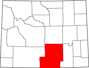
Location of Carbon County in Wyoming
It is intended to be a complete list of the properties and districts on the National Register of Historic Places in Carbon County, Wyoming, United States. The locations of National Register properties and districts for which the latitude and longitude coordinates are included below, may be seen in a map.[1]
There are 49 properties and districts listed on the National Register in the county, 1 of which is a National Historic Landmark.
- This National Park Service list is complete through NPS recent listings posted June 19, 2020.[2]
| Albany - Big Horn - Campbell - Carbon - Converse - Crook - Fremont - Goshen - Hot Springs - Johnson - Laramie - Lincoln - Natrona - Niobrara - Park - Platte - Sheridan - Sublette - Sweetwater - Teton - Uinta - Washakie - Weston |
Current listings
| [3] | Name on the Register | Image | Date listed[4] | Location | City or town | Description |
|---|---|---|---|---|---|---|
| 1 | Garrett Allen Prehistoric Site |  Garrett Allen Prehistoric Site |
August 7, 1974 (#74002023) |
Address Restricted |
Elk Mountain | |
| 2 | Arlington |  Arlington |
November 25, 1983 (#83004268) |
South of Interstate 80 41°35′42″N 106°12′34″W |
Arlington | |
| 3 | Jim Baker Cabin | 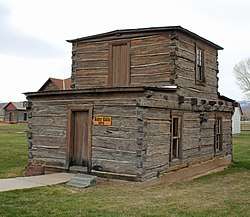 Jim Baker Cabin |
November 8, 1982 (#82001830) |
Off Wyoming Highway 70 41°01′36″N 107°26′57″W |
Savery | |
| 4 | Bridger's Pass | 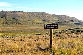 Bridger's Pass |
April 28, 1970 (#70000669) |
Southwest of Rawlins 41°33′03″N 107°26′04″W |
Rawlins | |
| 5 | Brush Creek Work Center |  Brush Creek Work Center |
April 11, 1994 (#94000276) |
Wyoming Highway 130 east of Saratoga, Medicine Bow National Forest 41°20′45″N 106°32′14″W |
Saratoga | Now the visitor center on the west side of the Snowy Range. |
| 6 | Carbon Cemetery | April 7, 2011 (#10001048) |
County Road 115 41°51′07″N 106°22′44″W |
Carbon | ||
| 7 | Como Bluff |  Como Bluff |
January 18, 1973 (#73001925) |
On U.S. Route 30 along Como Ridge 41°53′13″N 106°03′24″W |
Medicine Bow | Extends into Albany County |
| 8 | DFU Elk Mountain Bridge | 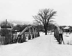 DFU Elk Mountain Bridge |
February 22, 1985 (#85000416) |
County Road 120-1 41°41′12″N 106°24′34″W |
Elk Mountain | Replaced in 2016[5] |
| 9 | Divide Sheep Camp | February 9, 1984 (#84003635) |
Northeast of Baggs 41°06′54″N 107°17′19″W |
Baggs | ||
| 10 | DMJ Pick Bridge |  DMJ Pick Bridge |
February 22, 1985 (#85000418) |
Next to Road CN6-508 (Pick Bridge Rd.) over the North Platte River 41°32′22″N 106°52′51″W |
Saratoga | |
| 11 | DML Butler Bridge |  DML Butler Bridge |
February 22, 1985 (#85000417) |
County Road CN6-203 over the North Platte River 41°15′23″N 106°38′22″W |
Grand Encampment | |
| 12 | Downtown Rawlins Historic District | 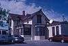 Downtown Rawlins Historic District |
May 16, 1985 (#85001119) |
Roughly 2nd to 6th Sts. and Front to Buffalo Sts.; also roughly along 5th St. from W. Spruce to W. Cedar 41°47′16″N 107°14′18″W |
Rawlins | Second set of boundaries represents a boundary increase |
| 13 | Duck Lake Station Site | Duck Lake Station Site |
December 6, 1978 (#78002825) |
Address Restricted |
Wamsutter | |
| 14 | Elk Mountain Hotel | 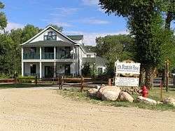 Elk Mountain Hotel |
October 10, 1986 (#86003233) |
Bridge St. and County Road 402 41°41′15″N 106°24′40″W |
Elk Mountain | |
| 15 | George Ferris Mansion | 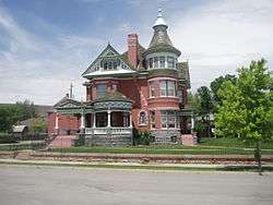 George Ferris Mansion |
November 1, 1982 (#82001831) |
607 W. Maple St. 41°47′29″N 107°14′34″W |
Rawlins | |
| 16 | First State Bank of Baggs |  First State Bank of Baggs |
September 13, 1984 (#84003644) |
10 S. Miles St. 41°02′09″N 107°39′31″W |
Baggs | |
| 17 | Fort Halleck | April 28, 1970 (#70000668) |
Southwest of Elk Mountain 41°41′53″N 106°30′55″W |
Elk Mountain | ||
| 18 | Fort Steele |  Fort Steele |
April 16, 1969 (#69000185) |
On the North Platte River at the Union Pacific railroad crossing 41°46′38″N 106°56′51″W |
Fort Fred Steele | |
| 19 | The Fossil Cabin |  The Fossil Cabin |
April 11, 2008 (#08000289) |
U.S. Route 30 41°51′55″N 106°04′23″W |
Medicine Bow | |
| 20 | France Memorial United Presbyterian Church | 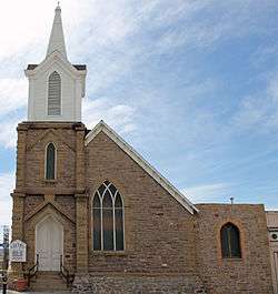 France Memorial United Presbyterian Church |
May 14, 1984 (#84003649) |
3rd and Cedar Sts. 41°47′17″N 107°14′14″W |
Rawlins | |
| 21 | Grand Encampment Mining Region: Boston Wyoming Smelter Site | July 2, 1973 (#73001927) |
East of Encampment on the Encampment River 41°12′35″N 106°46′46″W |
Grand Encampment | ||
| 22 | Grand Encampment Mining Region: Ferris-Haggarty Mine Site | July 2, 1973 (#73001928) |
West of Encampment 41°11′15″N 107°04′26″W |
Grand Encampment | ||
| 23 | Hanna Community Hall | Hanna Community Hall |
November 26, 1983 (#83004277) |
Front St. 41°52′09″N 106°33′51″W |
Hanna | |
| 24 | Headquarters Park Historic District |  Headquarters Park Historic District |
April 17, 2012 (#11000748) |
Approximately 1 mile (1.6 km) north of WY 130 on USFS road 103 41°20′16″N 106°21′41″W |
Centennial | |
| 25 | Hotel Wolf | 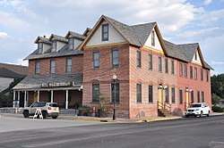 Hotel Wolf |
November 21, 1974 (#74002024) |
101 E. Bridge St. 41°27′17″N 106°48′24″W |
Saratoga | |
| 26 | Hugus Hardware |  Hugus Hardware |
April 5, 1984 (#84003656) |
123 E. Bridge St. 41°27′17″N 106°48′21″W |
Saratoga | |
| 27 | Jack Creek Guard Station | May 15, 1986 (#86001101) |
Off FDR 452 41°16′23″N 107°06′32″W |
Saratoga | ||
| 28 | J. O. Ranch Rural Historic Landscape | November 22, 2010 (#10000930) |
24 miles (39 km) northeast of Baggs[6] 41°21′10″N 107°35′59″W |
Baggs | ||
| 29 | Medicine Bow Union Pacific Depot | Medicine Bow Union Pacific Depot |
November 1, 1982 (#82001832) |
405 Lincoln Highway 41°53′43″N 106°11′59″W |
Medicine Bow | |
| 30 | Medicine House Site | May 4, 2018 (#100002396) |
Address Restricted |
Hanna vicinity | ||
| 31 | Midway Station Site | Midway Station Site |
December 6, 1978 (#78002819) |
Address Restricted |
Rawlins | |
| 32 | Muddy Creek Archeological Complex | Muddy Creek Archeological Complex |
May 16, 2012 (#12000291) |
Address Restricted |
Medicine Bow | |
| 33 | Parco Historic District |  Parco Historic District |
May 6, 1987 (#87000918) |
Roughly bounded by Monroe Ave., N. 4th St., Union and Lincoln Aves., and N. 9th St. 41°46′47″N 107°07′04″W |
Sinclair | |
| 34 | Pine Grove Station Site | Pine Grove Station Site |
November 21, 1978 (#78002820) |
Address Restricted |
Rawlins | |
| 35 | Platte River Crossing | August 12, 1971 (#71000885) |
17 miles (27 km) west of Saratoga 41°34′21″N 106°57′45″W |
Saratoga | ||
| 36 | Powder Wash Archeological District | Powder Wash Archeological District |
December 4, 2013 (#13000892) |
Address Restricted |
Baggs | |
| 37 | Rawlins Residential Historic District |  Rawlins Residential Historic District |
September 9, 1999 (#99001141) |
Roughly bounded by 8th St., Walnut St., Wyoming St., and Pine St. 41°47′28″N 107°14′19″W |
Rawlins | |
| 38 | Ryan Ranch |  Ryan Ranch |
March 29, 1978 (#78002823) |
South of Saratoga off Wyoming Highway 130 41°22′21″N 106°43′01″W |
Saratoga | |
| 39 | Sage Creek Station Site | Sage Creek Station Site |
December 6, 1978 (#78002821) |
Address Restricted |
Rawlins | |
| 40 | Saratoga Masonic Hall | March 29, 1978 (#78002824) |
1st and Main Sts. 41°27′20″N 106°48′26″W |
Saratoga | Probably demolished. | |
| 41 | Site 32 SL-O Intermediate Field Historic District | February 28, 2012 (#12000054) |
0.9 miles (1.4 km) southeast of Medicine Bow off County Road 1 41°53′11″N 106°11′18″W |
Medicine Bow | Also known as the Medicine Bow Airport[7] | |
| 42 | Stockgrowers Bank |  Stockgrowers Bank |
June 25, 1986 (#86001393) |
Third St. 41°02′04″N 107°32′08″W |
Dixon | |
| 43 | Stone Wall Ranch | September 29, 1986 (#86002329) |
Star Rt., Box 1300 41°01′10″N 107°25′13″W |
Savery | ||
| 44 | Tom Sun Ranch | 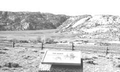 Tom Sun Ranch |
October 15, 1966 (#66000753) |
6 miles (9.7 km) west of Independence Rock on Wyoming Highway 220 42°26′40″N 107°14′36″W |
Independence Rock | |
| 45 | Union Pacific Railroad Depot | Union Pacific Railroad Depot |
September 2, 1993 (#93000883) |
Junction of N. Front and 4th Sts. 41°47′13″N 107°14′18″W |
Rawlins | |
| 46 | Virginian Hotel | .JPG) Virginian Hotel |
May 22, 1978 (#78002818) |
U.S. Route 30 41°53′46″N 106°11′59″W |
Medicine Bow | |
| 47 | Washakie Station Site | December 12, 1978 (#78002822) |
Off WYO 789, 30 miles (48 km) southwest of Rawlins[8] 41°28′48″N 107°41′39″W |
Rawlins | ||
| 48 | Willis House | 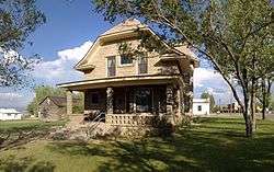 Willis House |
March 29, 2001 (#01000300) |
621 Winchell Ave. 41°12′27″N 106°47′42″W |
Grand Encampment | |
| 49 | Wyoming State Penitentiary District |  Wyoming State Penitentiary District |
May 26, 1983 (#83003360) |
6th and Walnut Sts. 41°47′37″N 107°14′26″W |
Rawlins |
See also
| Wikimedia Commons has media related to National Register of Historic Places in Carbon County, Wyoming. |
References
- The latitude and longitude information provided in this table was derived originally from the National Register Information System, which has been found to be fairly accurate for about 99% of listings. Some locations in this table may have been corrected to current GPS standards.
- "National Register of Historic Places: Weekly List Actions". National Park Service, United States Department of the Interior. Retrieved on June 19, 2020.
- Numbers represent an ordering by significant words. Various colorings, defined here, differentiate National Historic Landmarks and historic districts from other NRHP buildings, structures, sites or objects.
- The eight-digit number below each date is the number assigned to each location in the National Register Information System database, which can be viewed by clicking the number.
- U.S. Geological Survey. Geographic Names Phase I data compilation (1976-1981). 31-Dec-1981.
- Location derived from its GNIS feature record; the NRIS lists the site as "Address Restricted".
| Topics | |
|---|---|
| Lists by state |
|
| Lists by insular areas | |
| Lists by associated state | |
| Other areas | |
| Related | |
| |
Municipalities and communities of Carbon County, Wyoming, United States | ||
|---|---|---|
| Cities | | |
| Towns |
| |
| CDPs | ||
| Unincorporated communities | ||
| Ghost towns | ||
This article is issued from Wikipedia. The text is licensed under Creative Commons - Attribution - Sharealike. Additional terms may apply for the media files.