National Register of Historic Places listings in Darlington County, South Carolina
This is a list of items on the National Register of Historic Places listings in Darlington County, South Carolina.
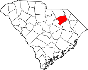
Location of Darlington County in South Carolina
This is intended to be a complete list of the properties and districts on the National Register of Historic Places in Darlington County, South Carolina, United States. The locations of National Register properties and districts for which the latitude and longitude coordinates are included below, may be seen in a map.[1]
There are 52 properties and districts listed on the National Register in the county, including one National Historic Landmark.
- This National Park Service list is complete through NPS recent listings posted June 19, 2020.[2]
Current listings
| [3] | Name on the Register[4] | Image | Date listed[5] | Location | City or town | Description |
|---|---|---|---|---|---|---|
| 1 | Arcade Hotel | 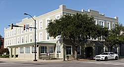 Arcade Hotel |
December 19, 1986 (#86003467) |
204 N. 5th St. 34°22′30″N 80°04′28″W |
Hartsville | |
| 2 | W.E. Cannon House and Store | W.E. Cannon House and Store |
May 3, 1991 (#91000470) |
612 W. Home Ave. 34°22′19″N 80°05′18″W |
Hartsville | |
| 3 | Cashua Street-Spring Street Historic District | 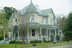 Cashua Street-Spring Street Historic District |
February 10, 1988 (#88000064) |
Cashua St. between Columbian St. and Warley St., and Spring St. between Cashua St. and N. Ervin St. 34°18′25″N 79°52′01″W |
Darlington | |
| 4 | Coker Experimental Farms | .jpg) Coker Experimental Farms |
October 15, 1966 (#66000706) |
West of Hartsville on South Carolina Highway 151 34°21′47″N 80°03′35″W |
Hartsville | National Historic Landmark |
| 5 | J.L. Coker Company Building |  J.L. Coker Company Building |
February 9, 1983 (#83002192) |
5th St. and Carolina Ave. 34°22′27″N 80°04′22″W |
Hartsville | |
| 6 | James L. Coker III House | May 3, 1991 (#91000471) |
620 W. Home Ave. 34°22′18″N 80°05′20″W |
Hartsville | ||
| 7 | Robert R. Coker House | 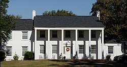 Robert R. Coker House |
September 8, 1994 (#94001130) |
1318 W. Carolina Ave. 34°22′01″N 80°06′22″W |
Hartsville | |
| 8 | S. Pressly Coker House | September 8, 1994 (#94001131) |
402 W. Home Ave. 34°22′16″N 80°04′52″W |
Hartsville | ||
| 9 | Julius A. Dargan House | 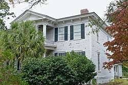 Julius A. Dargan House |
February 10, 1988 (#88000036) |
488 Pearl St. 34°18′00″N 79°52′38″W |
Darlington | |
| 10 | Darlington Downtown Historic District | .jpg) Darlington Downtown Historic District |
July 5, 2006 (#06000546) |
Along portions of S. Main St., Pearl St., Public Sq., and Exchange St. 34°18′10″N 79°52′17″W |
Darlington | |
| 11 | Darlington Industrial Historic District | February 10, 1988 (#88000062) |
Roughly bounded by 6th St., Ave. B, Dargan St., and Siskron St. 34°18′01″N 79°51′54″W |
Darlington | ||
| 12 | Darlington Memorial Cemetery | June 9, 2005 (#05000576) |
Ave. D and Friendship St. 34°17′34″N 79°51′22″W |
Darlington | ||
| 13 | Davidson Hall, Coker College | 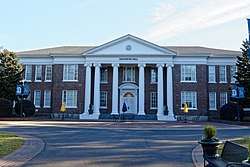 Davidson Hall, Coker College |
November 10, 1983 (#83003835) |
College Ave. 34°22′38″N 80°04′05″W |
Hartsville | |
| 14 | Edmund H. Deas House |  Edmund H. Deas House |
February 10, 1988 (#88000045) |
229 Ave. E 34°17′44″N 79°51′46″W |
Darlington | |
| 15 | Dove Dale | February 22, 2007 (#07000075) |
Address Restricted |
Darlington | ||
| 16 | C.K. Dunlap House | May 3, 1991 (#91000472) |
1346 W. Carolina Ave. 34°22′32″N 80°06′30″W |
Hartsville | ||
| 17 | East Home Avenue Historic District |  East Home Avenue Historic District |
May 3, 1991 (#91000475) |
Roughly E. Home Ave. from N. 5th St. to just east of 1st Ave. 34°22′45″N 80°04′14″W |
Hartsville | |
| 18 | First Baptist Church | 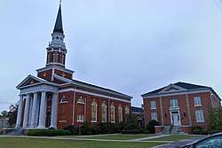 First Baptist Church |
October 17, 1991 (#88000061) |
246 S. Main St. 34°17′59″N 79°52′12″W |
Darlington | |
| 19 | J.B. Gilbert House |  J.B. Gilbert House |
May 3, 1991 (#91000473) |
200 Fairfield Terrace 34°22′48″N 80°04′26″W |
Hartsville | |
| 20 | Arthur Goodson House | October 10, 1985 (#85003137) |
West of County Road 133 34°20′42″N 79°51′14″W |
Springville | ||
| 21 | John L. Hart House |  John L. Hart House |
November 10, 1983 (#83003843) |
Home Ave. 34°22′36″N 80°04′26″W |
Hartsville | |
| 22 | John L. Hart House | October 10, 1985 (#85003138) |
East of County Road 133 34°20′42″N 79°51′07″W |
Springville | ||
| 23 | Thomas E. Hart House | 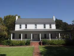 Thomas E. Hart House |
May 3, 1991 (#91000474) |
624 W. Carolina Ave. 34°22′01″N 80°06′57″W |
Hartsville | |
| 24 | Hartsville Armory | 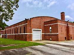 Hartsville Armory |
September 8, 1994 (#94001128) |
539 W. Carolina Ave. 34°22′09″N 80°05′06″W |
Hartsville | |
| 25 | Hartsville Community Center-Hartsville Community Market | Hartsville Community Center-Hartsville Community Market |
June 4, 1997 (#97000538) |
5th St. between College and Home Ave., and 106 W. College Ave. 34°22′32″N 80°04′28″W |
Hartsville | |
| 26 | Hartsville Passenger Station |  Hartsville Passenger Station |
June 29, 1976 (#76001700) |
114 S. 4th St. 34°22′24″N 80°04′26″W |
Hartsville | |
| 27 | Hartsville Post Office | 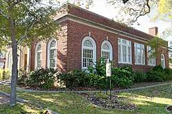 Hartsville Post Office |
June 4, 1997 (#97000537) |
Junction of Home Ave. and 5th St. 34°22′33″N 80°04′29″W |
Hartsville | |
| 28 | Wade Hampton Hicks House |  Wade Hampton Hicks House |
September 8, 1994 (#94001127) |
313 W. Home Ave. 34°22′26″N 80°04′47″W |
Hartsville | |
| 29 | Nelson Hudson House | February 10, 1988 (#88000039) |
521 Pearl St.** 34°17′56″N 79°52′40″W |
Darlington | **house since moved from original location to unknown site | |
| 30 | Japonica Hall | December 21, 1989 (#89002153) |
S. Main St. 34°30′21″N 79°51′35″W |
Society Hill | ||
| 31 | Jacob Kelley House | May 6, 1971 (#71000768) |
West of Hartsville on S-16-12 34°20′59″N 80°08′45″W |
Hartsville | ||
| 32 | Lawton Park and Pavilion |  Lawton Park and Pavilion |
May 3, 1991 (#91000476) |
Prestwood Dr. at its junction with Lanier Dr. 34°22′55″N 80°04′48″W |
Hartsville | |
| 33 | Evan J. Lide House | October 10, 1985 (#85003139) |
West of County Road 228 northwest of South Carolina Highway 34 34°19′46″N 79°50′57″W |
Springville | ||
| 34 | John W. Lide House | October 10, 1985 (#85003140) |
West of County Road 133 34°21′09″N 79°51′34″W |
Springville | ||
| 35 | Lydia Plantation |  Lydia Plantation |
May 28, 2010 (#10000299) |
703 W Lydia Hwy (US HWY 15/SC HWY 34) 34°17′28″N 80°06′18″W |
Lydia | |
| 36 | Magnolia Cemetery |  Magnolia Cemetery |
September 8, 1994 (#94001133) |
S. Cedar Ln. 34°21′52″N 80°05′28″W |
Hartsville | |
| 37 | Manne Building | 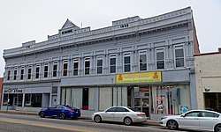 Manne Building |
February 10, 1988 (#88000044) |
129 Pearl St. 34°18′08″N 79°52′18″W |
Darlington | |
| 38 | Clarence McCall House | 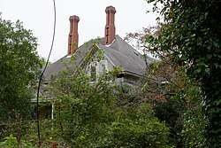 Clarence McCall House |
February 10, 1988 (#88000058) |
870 Cashua St. 34°18′35″N 79°51′46″W |
Darlington | |
| 39 | Charles S. McCullough House | 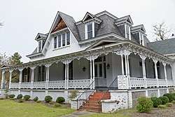 Charles S. McCullough House |
February 10, 1988 (#88000060) |
480 Pearl St. 34°18′01″N 79°52′36″W |
Darlington | |
| 40 | A.M. McNair House | A.M. McNair House |
September 8, 1994 (#94001126) |
153 W. Home Ave. 34°22′31″N 80°04′35″W |
Hartsville | |
| 41 | Memorial Hall | 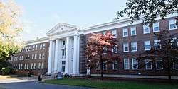 Memorial Hall |
February 9, 1989 (#89000001) |
2nd St. between Home Ave. and Carolina Ave. 34°22′42″N 80°04′01″W |
Hartsville | |
| 42 | Oaklyn Plantation | February 2, 1995 (#94001630) |
Junction of S. Charleston Rd. (South Carolina Highway 35) and Pocket Rd. (South Carolina Highway 173) 34°16′46″N 79°46′52″W |
Darlington | ||
| 43 | Paul H. Rogers House | 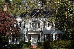 Paul H. Rogers House |
September 8, 1994 (#94001125) |
628 W. Home Ave. 34°22′17″N 80°05′22″W |
Hartsville | |
| 44 | St. John's Historic District | September 4, 1980 (#80003668) |
Park, St. John's, Sanders, and Orange Sts. 34°18′15″N 79°52′32″W |
Darlington | ||
| 45 | South Carolina Western Railway Station | 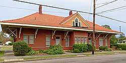 South Carolina Western Railway Station |
February 10, 1988 (#88000040) |
129 Russell St. 34°18′13″N 79°52′08″W |
Darlington | |
| 46 | Welsh Neck-Long Bluff-Society Hill Historic District | December 16, 1974 (#74001846) |
Southwest of Bennettsville along U.S. Route 15 34°31′35″N 79°49′39″W |
Bennettsville | ||
| 47 | West Broad Street Historic District | February 10, 1988 (#88000063) |
W. Broad St. between Dargan St. and Player St. 34°17′49″N 79°52′26″W |
Darlington | ||
| 48 | West College Avenue Historic District | September 8, 1994 (#94001123) |
W. College Ave. from 6th Ave. to west of 8th Ave. 34°22′24″N 80°04′43″W |
Hartsville | ||
| 49 | White Plains | October 10, 1985 (#85003141) |
North of County Road 177 and northeast of County Road 389 34°21′24″N 79°53′00″W |
Springville | ||
| 50 | Wilds Hall | October 10, 1985 (#85003142) |
West of County Road 228 off South Carolina Highway 34 34°19′05″N 79°50′33″W |
Springville | ||
| 51 | Wilds-Edwards House | 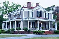 Wilds-Edwards House |
February 10, 1988 (#88000034) |
120 Edwards Ave. 34°17′54″N 79°52′33″W |
Darlington | |
| 52 | Mrs. B.F. Williamson House | 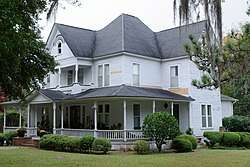 Mrs. B.F. Williamson House |
February 10, 1988 (#88000059) |
141 Oak St. 34°18′24″N 79°52′17″W |
Darlington |
See also
| Wikimedia Commons has media related to National Register of Historic Places in Darlington County, South Carolina. |
References
- The latitude and longitude information provided in this table was derived originally from the National Register Information System, which has been found to be fairly accurate for about 99% of listings. Some locations in this table may have been corrected to current GPS standards.
- "National Register of Historic Places: Weekly List Actions". National Park Service, United States Department of the Interior. Retrieved on June 19, 2020.
- Numbers represent an ordering by significant words. Various colorings, defined here, differentiate National Historic Landmarks and historic districts from other NRHP buildings, structures, sites or objects.
- "National Register Information System". National Register of Historic Places. National Park Service. March 13, 2009.
- The eight-digit number below each date is the number assigned to each location in the National Register Information System database, which can be viewed by clicking the number.
| Topics |  | |
|---|---|---|
| Lists by county |
| |
| Lists by city |
| |
| Other lists | ||
Municipalities and communities of Darlington County, South Carolina, United States | ||
|---|---|---|
| Cities | Map of South Carolina highlighting Darlington County | |
| Towns | ||
| CDP | ||
| Other unincorporated communities | ||
| Ghost towns | ||
| Footnotes | ‡This populated place also has portions in an adjacent county or counties | |
This article is issued from Wikipedia. The text is licensed under Creative Commons - Attribution - Sharealike. Additional terms may apply for the media files.