National Register of Historic Places listings in Lancaster County, South Carolina
This is a list of the National Register of Historic Places listings in Lancaster County, South Carolina.
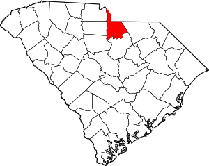
Location of Lancaster County in South Carolina
This is intended to be a complete list of the properties and districts on the National Register of Historic Places in Lancaster County, South Carolina, United States. The locations of National Register properties and districts for which the latitude and longitude coordinates are included below, may be seen in a map.[1]
There are 27 properties and districts listed on the National Register in the county, including 2 National Historic Landmarks. Another 2 properties were once listed but have been removed.
- This National Park Service list is complete through NPS recent listings posted June 19, 2020.[2]
Current listings
| [3] | Name on the Register[4] | Image | Date listed[5] | Location | City or town | Description |
|---|---|---|---|---|---|---|
| 1 | Robert Barnwell Allison House | 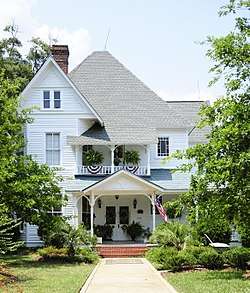 Robert Barnwell Allison House |
January 4, 1990 (#89002148) |
404 Chesterfield Ave. 34°43′02″N 80°45′43″W |
Lancaster | |
| 2 | Battle of Hanging Rock Historic Site | 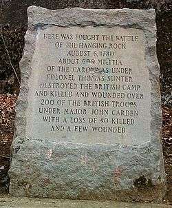 Battle of Hanging Rock Historic Site |
December 31, 1974 (#74001860) |
About 3.5 miles south of Heath Springs off U.S. Route 521 34°33′31″N 80°39′54″W |
Heath Springs | |
| 3 | Buford's Massacre Site | 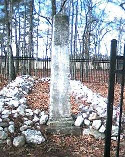 Buford's Massacre Site |
February 15, 1990 (#90000091) |
South Carolina Highway 522, 0.25 miles south of South Carolina Highway 9 34°44′26″N 80°37′35″W |
Tradesville | |
| 4 | Dr. William Columbus Cauthen House | 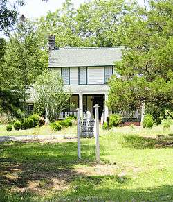 Dr. William Columbus Cauthen House |
June 28, 1982 (#82003872) |
South Carolina Highway 75 34°33′19″N 80°38′30″W |
Kershaw | |
| 5 | Clinton AME Zion Church | 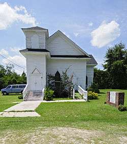 Clinton AME Zion Church |
February 16, 1990 (#90000092) |
Johnson and Church Sts. 34°32′57″N 80°35′14″W |
Kershaw | |
| 6 | Craig House | 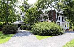 Craig House |
February 16, 1990 (#90000093) |
South Carolina Highway 185/Craig Dr. 34°45′28″N 80°46′01″W |
Lancaster | |
| 7 | Cureton House | 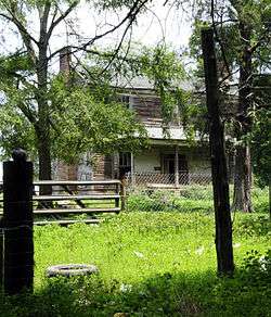 Cureton House |
September 4, 1990 (#90000094) |
County Road 29, south of County Road 39 34°48′29″N 80°51′02″W |
Lancaster | |
| 8 | East Richland Street-East Church Street Historic District | 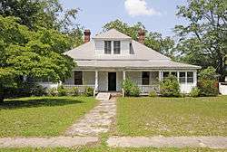 East Richland Street-East Church Street Historic District |
January 4, 1990 (#89002142) |
Roughly bounded by E. Church St., Ingram St., E. Richland St., and Hart St. 34°33′03″N 80°34′47″W |
Kershaw | |
| 9 | Heath Springs Depot |  Heath Springs Depot |
January 4, 1990 (#89002147) |
E. Railroad Ave. 34°35′39″N 80°40′30″W |
Heath Springs | |
| 10 | Thomas Walker Huey House | 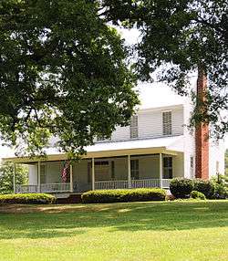 Thomas Walker Huey House |
January 4, 1990 (#89002146) |
Junction of South Carolina Highways 200 and 285 34°48′54″N 80°43′01″W |
Lancaster | |
| 11 | Adam Ivy House | September 4, 1990 (#89002144) |
South Carolina Highway 55, 1.5 miles southwest of its junction with County Road 2109 34°53′25″N 80°51′37″W |
Van Wyck | ||
| 12 | Kershaw Depot | 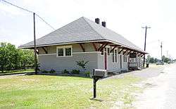 Kershaw Depot |
February 16, 1990 (#90000096) |
Cleveland St. 34°32′49″N 80°34′58″W |
Kershaw | |
| 13 | Lancaster Cotton Oil Company | 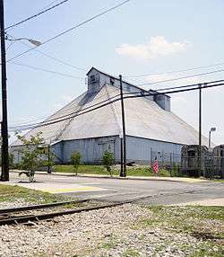 Lancaster Cotton Oil Company |
February 6, 1990 (#89002145) |
S. Main St. at the Lancaster and Chester railroad tracks 34°42′51″N 80°46′01″W |
Lancaster | |
| 14 | Lancaster County Courthouse | %2C_Lancaster%2C_South_Carolina.jpg) Lancaster County Courthouse |
February 24, 1971 (#71000788) |
104 N. Main St. 34°43′09″N 80°46′27″W |
Lancaster | |
| 15 | Lancaster County Jail | _Jail.jpg) Lancaster County Jail |
August 9, 1971 (#71000789) |
208 W. Gay St. 34°43′09″N 80°46′19″W |
Lancaster | |
| 16 | Lancaster Downtown Historic District |  Lancaster Downtown Historic District |
August 9, 1984 (#84002048) |
S. Main, Gay, and Catawba Sts. 34°43′05″N 80°46′12″W |
Lancaster | |
| 17 | Lancaster Presbyterian Church | 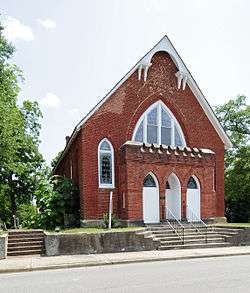 Lancaster Presbyterian Church |
December 16, 1977 (#77001228) |
W. Gay St. 34°43′02″N 80°46′25″W |
Lancaster | |
| 18 | Massey-Doby-Nisbet House | 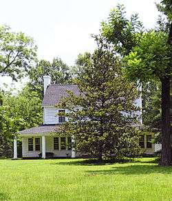 Massey-Doby-Nisbet House |
February 16, 1990 (#90000095) |
South Carolina Highway 55, southwest of County Road 2109 34°52′51″N 80°51′47″W |
Van Wyck | |
| 19 | Matson Street Historic District | 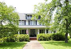 Matson Street Historic District |
September 4, 1990 (#89002143) |
Matson St. from Hilton to Pine Sts. 34°32′53″N 80°35′08″W |
Kershaw | |
| 20 | Mount Carmel A.M.E. Zion Campground | 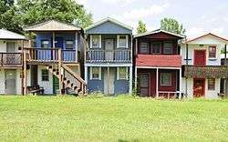 Mount Carmel A.M.E. Zion Campground |
May 10, 1979 (#79002386) |
South of Lancaster 34°35′47″N 80°46′45″W |
Lancaster | |
| 21 | North Carolina-South Carolina Cornerstone | 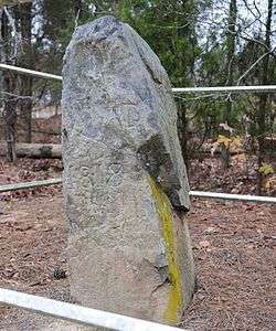 North Carolina-South Carolina Cornerstone |
December 20, 1984 (#84001115) |
Off U.S. Route 521 34°49′10″N 80°47′51″W |
Lancaster | |
| 22 | Perry-McIlwain-McDow House | 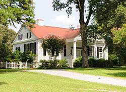 Perry-McIlwain-McDow House |
September 8, 2011 (#11000650) |
2297 Douglas Rd. 34°39′31″N 80°46′25″W |
Lancaster vicinity | |
| 23 | William Harrison Sapp House | 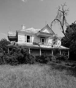 William Harrison Sapp House |
January 4, 1990 (#89002141) |
South Carolina Highways 51 and 522 34°47′53″N 80°38′01″W |
Tradesville | |
| 24 | Leroy Springs House | 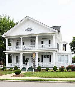 Leroy Springs House |
March 20, 1986 (#86000467) |
Catawba and Gay Sts. 34°43′05″N 80°45′37″W |
Lancaster | |
| 25 | Unity Baptist Church | 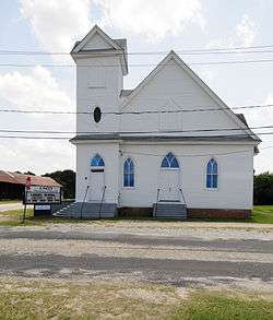 Unity Baptist Church |
February 16, 1990 (#90000098) |
Sumter and Hart Sts. 34°32′49″N 80°34′50″W |
Kershaw | |
| 26 | Wade-Beckham House | 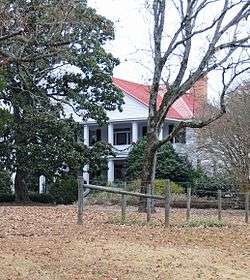 Wade-Beckham House |
June 17, 1988 (#88000669) |
South Carolina Highway 200 34°39′33″N 80°49′54″W |
Lancaster | |
| 27 | Waxhaw Presbyterian Church Cemetery | 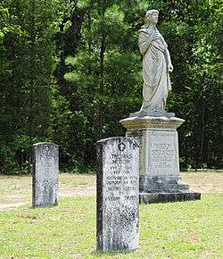 Waxhaw Presbyterian Church Cemetery |
September 11, 1975 (#75001701) |
8 miles north of Lancaster off U.S. Route 521 34°47′20″N 80°50′52″W |
Lancaster |
Former listings
| [3] | Name on the Register | Image | Date listed | Date removed | Location | City or town | Summary |
|---|---|---|---|---|---|---|---|
| 1 | Kilburnie | April 24, 1979 (#79002385) | December 8, 2005 | 204 North White Street |
Lancaster | Delisted after being moved[6] | |
| 2 | Stewart-Sapp House | February 16, 1990 (#90000097) | March 15, 2005 | South Carolina Highway 522 and South Carolina Highway 28 |
Tradesville | Burned down[7] |
See also
| Wikimedia Commons has media related to National Register of Historic Places in Lancaster County, South Carolina. |
References
- The latitude and longitude information provided in this table was derived originally from the National Register Information System, which has been found to be fairly accurate for about 99% of listings. Some locations in this table may have been corrected to current GPS standards.
- "National Register of Historic Places: Weekly List Actions". National Park Service, United States Department of the Interior. Retrieved on June 19, 2020.
- Numbers represent an ordering by significant words. Various colorings, defined here, differentiate National Historic Landmarks and historic districts from other NRHP buildings, structures, sites or objects.
- "National Register Information System". National Register of Historic Places. National Park Service. March 13, 2009.
- The eight-digit number below each date is the number assigned to each location in the National Register Information System database, which can be viewed by clicking the number.
| Topics |  | |
|---|---|---|
| Lists by county |
| |
| Lists by city |
| |
| Other lists | ||
Municipalities and communities of Lancaster County, South Carolina, United States | ||
|---|---|---|
| City | Map of South Carolina highlighting Lancaster County | |
| Towns | ||
| CDPs | ||
| Unincorporated communities | ||
| Footnotes | ‡This populated place also has portions in an adjacent county or counties | |
This article is issued from Wikipedia. The text is licensed under Creative Commons - Attribution - Sharealike. Additional terms may apply for the media files.