National Cycle Route 688
National Cycle Network (NCN) Route 688 is a Sustrans National Route that runs from Winterburn to Linton-on-Ouse[2]. It is 55 miles (89 km), fully open and signed.
| NCN Route 688 | |
|---|---|
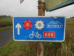 A typical Route 688 sign showing the Way of the Roses red and white roses, a direction arrow and route number | |
| Established | 2010 |
| Length | 55 mi (89 km) |
| Location | Yorkshire, United Kingdom |
| Designation | UK National Cycle Network |
| Trailheads | Winterburn (west) 54.0226°N 2.1025°W Linton-on-Ouse (east) 54.0387°N 1.2351°W |
| Use | Cycling |
| Elevation | |
| Highest point | Greenhow, 404[1] m (1,325 ft) |
| Lowest point | Linton-on-Ouse, 16 m (52 ft) |
| Cycling details | |
| Trail difficulty | Hard |
| Waymark |  |
| Surface | On-road |
| Website | |
National Cycle Route 688 | |||||||||||||||||||||||||||||||||||||||||||||||||||||||||||||||||||||||||||||||||||||||||||||||||||||||||||||||||||||||||||||||||||||||||||||||||||||||||||||||||
|---|---|---|---|---|---|---|---|---|---|---|---|---|---|---|---|---|---|---|---|---|---|---|---|---|---|---|---|---|---|---|---|---|---|---|---|---|---|---|---|---|---|---|---|---|---|---|---|---|---|---|---|---|---|---|---|---|---|---|---|---|---|---|---|---|---|---|---|---|---|---|---|---|---|---|---|---|---|---|---|---|---|---|---|---|---|---|---|---|---|---|---|---|---|---|---|---|---|---|---|---|---|---|---|---|---|---|---|---|---|---|---|---|---|---|---|---|---|---|---|---|---|---|---|---|---|---|---|---|---|---|---|---|---|---|---|---|---|---|---|---|---|---|---|---|---|---|---|---|---|---|---|---|---|---|---|---|---|---|---|---|---|
| |||||||||||||||||||||||||||||||||||||||||||||||||||||||||||||||||||||||||||||||||||||||||||||||||||||||||||||||||||||||||||||||||||||||||||||||||||||||||||||||||
History
Route 688 was created as an integral part of the Way of the Roses coast-to-coast route between Morecambe and Bridlington which opened on 11 September 2010[3].
Route
The western trailhead is at Winterburn (54.0226°N 2.1025°W), in the Yorkshire Dales, where it meets Route 68, the Pennine Cycle Way. It passes through Cracoe and Burnsall before climbing to the routes high point at Greenhow followed by a steep descent into Pateley Bridge. A further climb to Brimham Rocks is followed by a gradual descent on to the Vale of York via Fountains Abbey and Ripon. From here the route is flat as it follows the River Ouse via Boroughbridge and crossing it at Aldwark Bridge. The eastern trail head is at a junction with Route 65 at Linton-on-Ouse (54.0387°N 1.2351°W).[4]
Related NCN routes
Route 688 is part of the Way of the Roses along with[5]:
Route 688 meets the following routes:
- Route 68 at Winterburn (54.0226°N 2.1025°W),
- Route 67 near Fountains Abbey (54.0914°N 1.5771°W).
- Route 65 at Linton-on-Ouse (54.0387°N 1.2351°W).
References
- "Way of the Roses – LDWA Long Distance Paths". www.ldwa.org.uk. Retrieved 26 February 2018.
- "Route 688 - Map". Sustrans. Retrieved 26 February 2018.
- "Way of the Roses flyer" (PDF). bridlingtonrenaissance.com. Retrieved 26 February 2018.
- "Way of the Roses – Map". Sustrans. Retrieved 26 February 2018.
- Douglas, Rupert (2013). Way of the Roses : the official guide to the National Cycle Network coast to coast cycle route from Morecambe to Bridlington. ISBN 1901389871.