National Cycle Route 166
National Cycle Network (NCN) Route 166 is a Sustrans regional route in the Yorkshire Wolds between Kirkham and Hunmanby. It is one of 5 NCN routes that make up the 146 mile Yorkshire Wolds Cycle Route.[1] Created in 2011[2] it is fully open and signed.
| NCN Route 166 | |||||||||||||||||||||||||||||||||||||||||||||||||||||||||||||||||||||||||||||||||||||||||||||||||||||||||||||||||||||||||||||||||||||||||||||||||
|---|---|---|---|---|---|---|---|---|---|---|---|---|---|---|---|---|---|---|---|---|---|---|---|---|---|---|---|---|---|---|---|---|---|---|---|---|---|---|---|---|---|---|---|---|---|---|---|---|---|---|---|---|---|---|---|---|---|---|---|---|---|---|---|---|---|---|---|---|---|---|---|---|---|---|---|---|---|---|---|---|---|---|---|---|---|---|---|---|---|---|---|---|---|---|---|---|---|---|---|---|---|---|---|---|---|---|---|---|---|---|---|---|---|---|---|---|---|---|---|---|---|---|---|---|---|---|---|---|---|---|---|---|---|---|---|---|---|---|---|---|---|---|---|---|---|
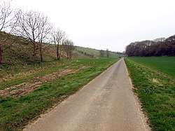 Route 166 in the Yorkshire Wolds near Fordon | |||||||||||||||||||||||||||||||||||||||||||||||||||||||||||||||||||||||||||||||||||||||||||||||||||||||||||||||||||||||||||||||||||||||||||||||||
| Length | 61 km (38 mi) | ||||||||||||||||||||||||||||||||||||||||||||||||||||||||||||||||||||||||||||||||||||||||||||||||||||||||||||||||||||||||||||||||||||||||||||||||
| Designation | UK National Cycle Network | ||||||||||||||||||||||||||||||||||||||||||||||||||||||||||||||||||||||||||||||||||||||||||||||||||||||||||||||||||||||||||||||||||||||||||||||||
| Trailheads | Kirkham (west) to Hunmanby (east) | ||||||||||||||||||||||||||||||||||||||||||||||||||||||||||||||||||||||||||||||||||||||||||||||||||||||||||||||||||||||||||||||||||||||||||||||||
| Use | Cycling | ||||||||||||||||||||||||||||||||||||||||||||||||||||||||||||||||||||||||||||||||||||||||||||||||||||||||||||||||||||||||||||||||||||||||||||||||
| Elevation | |||||||||||||||||||||||||||||||||||||||||||||||||||||||||||||||||||||||||||||||||||||||||||||||||||||||||||||||||||||||||||||||||||||||||||||||||
| Elevation gain/loss | 535 metres (1,760 ft) gain 510 metres (1,670 ft) loss | ||||||||||||||||||||||||||||||||||||||||||||||||||||||||||||||||||||||||||||||||||||||||||||||||||||||||||||||||||||||||||||||||||||||||||||||||
| Highest point | Settrington Beacon, 201 m (659 ft) | ||||||||||||||||||||||||||||||||||||||||||||||||||||||||||||||||||||||||||||||||||||||||||||||||||||||||||||||||||||||||||||||||||||||||||||||||
| Lowest point | Menethorpe, 20 m (66 ft) | ||||||||||||||||||||||||||||||||||||||||||||||||||||||||||||||||||||||||||||||||||||||||||||||||||||||||||||||||||||||||||||||||||||||||||||||||
| Cycling details | |||||||||||||||||||||||||||||||||||||||||||||||||||||||||||||||||||||||||||||||||||||||||||||||||||||||||||||||||||||||||||||||||||||||||||||||||
| Waymark |  | ||||||||||||||||||||||||||||||||||||||||||||||||||||||||||||||||||||||||||||||||||||||||||||||||||||||||||||||||||||||||||||||||||||||||||||||||
| Website | sustrans.org.uk | ||||||||||||||||||||||||||||||||||||||||||||||||||||||||||||||||||||||||||||||||||||||||||||||||||||||||||||||||||||||||||||||||||||||||||||||||
| |||||||||||||||||||||||||||||||||||||||||||||||||||||||||||||||||||||||||||||||||||||||||||||||||||||||||||||||||||||||||||||||||||||||||||||||||
Route
The entire 61 kilometres (38 mi)[3] route is on road, along quiet country lanes. The western end is at Kirkham, North Yorkshire, where it joins the north western end of NCN 167. It passes through the town of Norton-on-Derwent and then the villages of Settrington, Duggleby, Kirby Grindalythe, Sledmere, Weaverthorpe and Foxholes on its way to its eastern end at Hunmanby.[4] Here it meets NCN 1.
The Yorkshire Wolds is a rolling landscape, there are few flat sections in this route and there is an accumulated ascent of 535 metres (1,760 ft) and 510 metres (1,670 ft) of accumulated descent [3].
The steepest gradients are the climbs out of Norton and Settrington[3].
Related NCN Routes
Route 166 meets the following routes:
- 167 at Kirkham 54.0829°N 0.873°W
- 1 at Hunmanby 54.182°N 0.3255°W
NCN 166 is part of the Yorkshire Wolds Cycle Route with:
References
- "Yorkshire Wolds Cycle Route". Cycle the Yorkshire Wolds. Cooper Douglas Partnership. Retrieved 7 November 2016.
- Wills, Dixie. "Yorkshire Wolds Cycle Route: 146 miles of back roads and huge skies". The Guardian. Retrieved 7 November 2016.
- "Waymarked Trails - Cycling". cycling.waymarkedtrails.org. Retrieved 8 March 2019.
- Sustrans (2014). Yorkshire Wolds, York & the Humber Cycle Map 28 (1 ed.). Sustrans. p. 2. ISBN 1900623455.