National Cycle Route 141
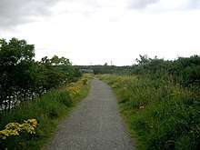
National Cycle Network (NCN) Route 141 is a Sustrans Regional Route. It is 11.2 km (7.0 mi) long.[1] It provides a connection between Route 14 and Route 72 along the south bank of the River Tyne through Gateshead. The full length of the route is part of the Keelmans Way. It is fully signed and open.
| National Cycle Route 141 | |
|---|---|
 | |
| Part of Keelman's Way | |
| Length | 11.2 km (7 mi) |
| Location | Metropolitan Borough of Gateshead |
| Designation | UK National Cycle Network |
| Trailheads | |
| Use |
|
| Cycling details | |
| Waymark | |
| Website | www |
| Trail map | |
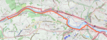 Map of National Cycle Route 141 | |
Route
NCN 141 starts at National Cycle Route 72, in Wylam on the north bank of the River Tyne. It crosses the river on Wylam Bridge before heading east via an off road route along the south bank of the Tyne. It passes Tyneside Golf Club[2], Ryton Willows[3] and Blaydon before reaching its eastern trailhead at Derwenthaugh (in Swalwell) where it meets National Cycle Route 14.[4]
The eastern end of the route was opened in 2012 so cyclists could avoid having to cross the busy Newburn Bridge to reach route 72.[5] There are public artworks as the route passes the site of the Baldon racecourse.[6]
Related NCN Routes
Route 141 meets the following routes:
Route 141 is part of the Keelmans Way along with Route 14[7]
References
- "Route 141". Sustrans. Retrieved 4 March 2020.
- "CycleStreets Photomap: Route sign for Keelman's Way (NCN 141) alongside Ryton Golf Course". CycleStreets. Retrieved 3 January 2019.
- "Keelman's Way". NewcastleGateshead. Retrieved 4 March 2020.
- "NZ2063 : A major junction on the National Cycle Network". Geograph. 27 September 2017. Retrieved 3 January 2019.
- "Keelman's Way cycle route link opened in Roy Deane's memory". BBC News. BBC. 14 June 2012. Retrieved 3 January 2019.
- Warren, Michael (25 August 2014). "Seaton Sluice Backpedalers: We Went To Blaydon Races ..." Seaton Sluice Backpedalers. Retrieved 3 January 2019.
- "NZ1963 : Scotswood Bridge and the Keelman's Way". Geograph. 28 September 2017. Retrieved 4 March 2020.