Nankai District
Nankai District (simplified Chinese: 南开区; traditional Chinese: 南開區; pinyin: Nánkāi Qū) is a district of Tianjin, People's Republic of China. Nankai District borders the Hai River in the east and Chentangzhuang Railway in the west and south.
Nankai 南开区 | ||||||||||||||||||||||||||||||||||||||||||||||||
|---|---|---|---|---|---|---|---|---|---|---|---|---|---|---|---|---|---|---|---|---|---|---|---|---|---|---|---|---|---|---|---|---|---|---|---|---|---|---|---|---|---|---|---|---|---|---|---|---|
District | ||||||||||||||||||||||||||||||||||||||||||||||||
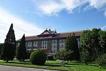
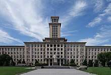 Nankai University | ||||||||||||||||||||||||||||||||||||||||||||||||

| ||||||||||||||||||||||||||||||||||||||||||||||||
| Coordinates: 39°08′18″N 117°09′0″E | ||||||||||||||||||||||||||||||||||||||||||||||||
| Country | People's Republic of China | |||||||||||||||||||||||||||||||||||||||||||||||
| Municipality | Tianjin | |||||||||||||||||||||||||||||||||||||||||||||||
| Township-level divisions | 12 subdistricts | |||||||||||||||||||||||||||||||||||||||||||||||
| Area | ||||||||||||||||||||||||||||||||||||||||||||||||
| • Total | 40.64 km2 (15.69 sq mi) | |||||||||||||||||||||||||||||||||||||||||||||||
| Elevation | 7 m (23 ft) | |||||||||||||||||||||||||||||||||||||||||||||||
| Population | ||||||||||||||||||||||||||||||||||||||||||||||||
| • Total | 811,000 | |||||||||||||||||||||||||||||||||||||||||||||||
| • Density | 20,000/km2 (52,000/sq mi) | |||||||||||||||||||||||||||||||||||||||||||||||
| Time zone | UTC+8 (China Standard) | |||||||||||||||||||||||||||||||||||||||||||||||
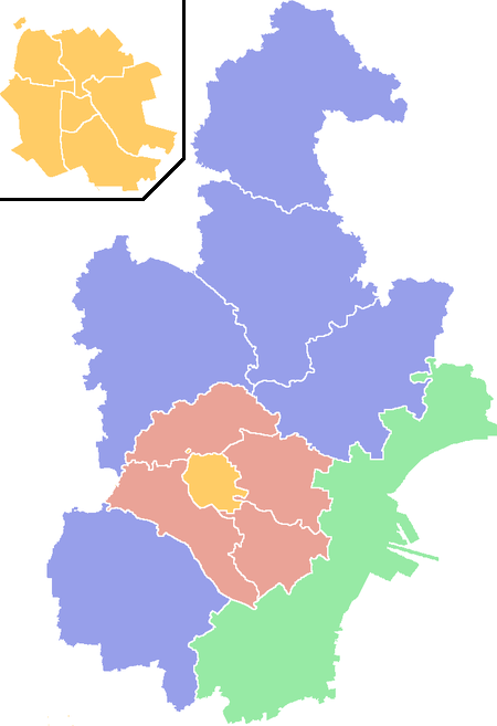
| Tianjin district map |
| |||||||||||||||||||||||||||||||||||||||||||||||
| Website | tjnk | |||||||||||||||||||||||||||||||||||||||||||||||
A number of important Tianjin landmarks lie in the district including the Tianjin Museum, Tianjin Radio and Television Tower, Tianjin Water Park, Tianjin Zoo and Tianjin Olympic Center Stadium. Nankai is also home to the city's most prestigious educational institutions including Tianjin University and Nankai University. The Tianjin New Technology Industrial Area, a 12 square km precinct, is also located in Nankai.
History
Historically, northern parts of Nankai District were located inside the walled city of Tianjin. The Tianfei Palace or Palace of the Queen of Heaven of the Yuan Dynasty was built in north-eastern Nankai in the year 1326. In the Ming Dynasty, the heart of the city of Tianjin was set up in Nankai. Nankai became part of the military garrisons during the Ming and Qing Dynasties and the city wall served as a major defense system against foreign invasion in the late 19th century.
Administrative divisions
There are 12 subdistricts in the district:[1]
| Name | Chinese (S) | Hanyu Pinyin | Population (2010)[2] | Area (km2) |
|---|---|---|---|---|
| Changhong Subdistrict | 长虹街道 | Chánghóng Jiēdào | 73,346 | 2.635 |
| Gulou Subdistrict | 鼓楼街道 | Gǔlóu Jiēdào | 28,788 | 2.117 |
| Xingnan Subdistrict | 兴南街道 | Xìngnán Jiēdào | 43,744 | 1.7 |
| Guangkai Subdistrict | 广开街道 | Guǎngkāi Jiēdào | 73,299 | 1.7 |
| Wanxing Subdistrict | 万兴街道 | Wànxìng Jiēdào | 140,684 | 3.54 |
| Xuefu Subdistrict | 学府街道 | Xuéfǔ Jiēdào | 103,319 | 4.7 |
| Xiangyang Road Subdistrict | 向阳路街道 | Xiàngyánglù Jiēdào | 145,263 | 3.887 |
| Jialing Street Subdistrict | 嘉陵道街道 | Jiālíngdào Jiēdào | 102,405 | 3.672 |
| Wangdingti Subdistrict | 王顶堤街道 | Wángdǐngdī Jiēdào | 122,599 | 5.016 |
| Shuishanggongyuan Subdistrict | 水上公园街道 | Shuǐshànggōngyuán Jiēdào | 64,853 | 5.633 |
| Tiyuzhongxin Subdistrict | 体育中心街道 | Tǐyùzhōngxīn Jiēdào | 66,948 | 5.26 |
| Huayuan Subdistrict | 华苑街道 | Huáyuàn Jiēdào | 52,948 | 1.67 |
Geography
Nankai District is located in the south-west corner of the urban Tianjin, bordered by Hongqiao District to the north, Hebei and Heping Districts to the north-east, Hexi District to the east and Xiqing District to the south-west. It occupies an area of 40.64 square kilometres (15.69 sq mi). The natural topography is characterised by higher elevation in the north of the district and a lower elevation in the south, with the average altitude being 3 metres.
Demographics
Nankai District has been one of the fastest growing districts in Tianjin since the formation of the People's Republic of China. The population was 220,000 in 1949. In 2006, the population was 925,000 and the density was 19621/km2 (50818/sq. mi.).
The rate of population growth has been negative since 1993 with the birth rate averaging 3.97% and death rate registering 4.56% in 2005.
The majority of people in Nankai District are Han Chinese. Small populations of ethnic minorities such as the Hui, Manchu and Mongol peoples also exist.
Transportation
Metro
Nankai is currently served by three metro lines operated by Tianjin Metro:
Parks
- Tianjin Zoo (天津动物园)
- Tianjin Water Park (天津水上公园)
- Changhong Park (长虹公园)
References
- 2011年统计用区划代码和城乡划分代码:南开区 (in Chinese). National Bureau of Statistics of the People's Republic of China. Archived from the original on 2012-10-31. Retrieved 2013-08-08.
- shi, Guo wu yuan ren kou pu cha ban gong; council, Guo jia tong ji ju ren kou he jiu ye tong ji si bian = Tabulation on the 2010 population census of the people's republic of China by township / compiled by Population census office under the state; population, Department of; statistics, employment statistics national bureau of (2012). Zhongguo 2010 nian ren kou pu cha fen xiang, zhen, jie dao zi liao (Di 1 ban. ed.). Beijing Shi: Zhongguo tong ji chu ban she. ISBN 978-7-5037-6660-2.
People's Government of Tianjin Nankai District English Website
| ||
| Districts |  | |
| Defunct Districts | ||