Wuqing District
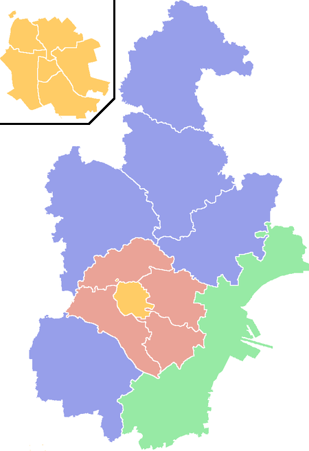
Wuqing District (simplified Chinese: 武清区; traditional Chinese: 武清區; pinyin: Wǔqīng Qū) is a district of Tianjin, bordering Hebei province to the north and west, Beijing Municipality to the northwest, Baodi District to the northeast, and Beichen District and Xiqing District to the southeast/south.
Wuqing 武清区 Wutsing | ||||||||||||||||||||||||||||||||||||||||||||||||
|---|---|---|---|---|---|---|---|---|---|---|---|---|---|---|---|---|---|---|---|---|---|---|---|---|---|---|---|---|---|---|---|---|---|---|---|---|---|---|---|---|---|---|---|---|---|---|---|---|
District | ||||||||||||||||||||||||||||||||||||||||||||||||
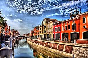 Florentia Village in the district | ||||||||||||||||||||||||||||||||||||||||||||||||
| ||||||||||||||||||||||||||||||||||||||||||||||||
| Coordinates: 39°23′03″N 117°02′40″E | ||||||||||||||||||||||||||||||||||||||||||||||||
| Country | People's Republic of China | |||||||||||||||||||||||||||||||||||||||||||||||
| Municipality | Tianjin | |||||||||||||||||||||||||||||||||||||||||||||||
| Township-level divisions | 6 subdistricts 19 towns 5 townships | |||||||||||||||||||||||||||||||||||||||||||||||
| Area | ||||||||||||||||||||||||||||||||||||||||||||||||
| • Total | 1,570 km2 (610 sq mi) | |||||||||||||||||||||||||||||||||||||||||||||||
| Elevation | 9 m (29 ft) | |||||||||||||||||||||||||||||||||||||||||||||||
| Population | ||||||||||||||||||||||||||||||||||||||||||||||||
| • Total | 840,000 | |||||||||||||||||||||||||||||||||||||||||||||||
| • Density | 540/km2 (1,400/sq mi) | |||||||||||||||||||||||||||||||||||||||||||||||
| Time zone | UTC+8 (China Standard) | |||||||||||||||||||||||||||||||||||||||||||||||
| Postal code | 301700 | |||||||||||||||||||||||||||||||||||||||||||||||
| Area code(s) | 0022 | |||||||||||||||||||||||||||||||||||||||||||||||
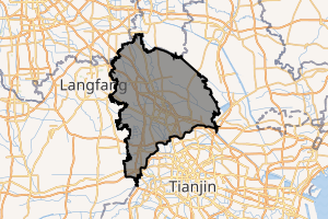
| Tianjin district map |
| |||||||||||||||||||||||||||||||||||||||||||||||
| Website | tjwq | |||||||||||||||||||||||||||||||||||||||||||||||
Administrative divisions
There are 6 subdistricts, 19 towns, and 5 townships in the district:[1]
| Name | Chinese (S) | Hanyu Pinyin | Population (2010)[2] | Area (km2) |
|---|---|---|---|---|
| Yunhexi Subdistrict | 运河西街道 | Yùnhéxī Jiēdào | 68,661 | |
| Yangcun Subdistrict (Yangtsun) | 杨村街道 | Yángcūn Jiēdào | 45,947 | 24 |
| Xuguantun Subdistrict | 徐官屯街道 | Xúguāntún Jiēdào | 16,981 | 19 |
| Xiazhuzhuang Subdistrict | 下朱庄街道 | Xiàzhūzhuāng Jiēdào | 24,295 | |
| Huangzhuang Subdistrict | 黄庄街道 | Huángzhuāng Jiēdào | 16,881 | |
| Dongpuwa Subdistrict | 东蒲洼街道 | Dōngpúwā Jiēdào | 44,808 | 48.31 |
| Dongmaquan town | 东马圈镇 | Dōngmǎquān Zhèn | 15,850 | 38 |
| Huanghuadian town | 黄花淀镇 | Huánghuādiàn Zhèn | 24,100 | 53 |
| Shigezhuang town | 石各庄镇 | Shígèzhuāng Zhèn | 23,309 | 45 |
| Tianqingtuo town | 王庆坨镇 | Wángqìng tuó Zhèn | 45,016 | 54 |
| Chagu town | 汊沽港镇 | Chàgū Zhèn | 44,843 | 58.48 |
| Chenzui town | 陈咀镇 | Chénzuǐ Zhèn | 30,193 | 61.32 |
| Meichang town | 梅厂镇 | Méichǎng Zhèn | 35,033 | 70 |
| Shangmatai town | 上马台镇 | Shàngmǎtái Zhèn | 22,081 | 66 |
| Cuihuangkou town | 崔黄口镇 | Cuīhuángkǒu Zhèn | 51,541 | 90 |
| Hebeitun town | 河北屯镇 | Héběitún Zhèn | 30,418 | 45 |
| Xiawuqi town | 下伍旗镇 | Xiàwǔqí Zhèn | 23,889 | 50 |
| Dajianchang town | 大碱厂镇 | Dàjiǎnchǎng Zhèn | 22,323 | |
| Daliang town | 大良镇 | Dàliáng Zhèn | 39,379 | 80.2 |
| Chengguan town | 城关镇 | Chéngguān Zhèn | 27,050 | 56 |
| Damengzhuang town | 大孟庄镇 | Dàmèngzhuāng Zhèn | 22,162 | 47 |
| Sicundian town | 泗村店镇 | Sìcūndiàn Zhèn | 17,247 | 52.6 |
| Hexiwu town | 河西务镇 | Héxīwù Zhèn | 45,814 | 70 |
| Nancaicun town | 南蔡村镇 | Náncàicūn Zhèn | 47,091 | |
| Dawangguzhuang town | 大王古庄镇 | Dàwánggǔzhuāng Zhèn | 25,061 | 48.08 |
| Douzhangzhuang town | 豆张庄镇 | Dòuzhāngzhuāng Zhèn | 23,421 | 67 |
| Dahuangbao town | 大黄堡镇 | Dàhuángbǎo Zhèn | 18,432 | 102 |
| Caozili town | 曹子里镇 | Cáozilǐ Zhèn | 27,133 | 12.7 |
| Baigutun town | 白古屯镇 | Báigǔtún Zhèn | 21,443 | 53 |
| Gaocun town | 高村镇 | Gāocūn Zhèn | 18,210 | 43 |
| developmental & farming zones | 32,466 |
References
- 2011年统计用区划代码和城乡划分代码:武清区 (in Chinese). National Bureau of Statistics of the People's Republic of China. Retrieved 2013-08-08.
- shi, Guo wu yuan ren kou pu cha ban gong; council, Guo jia tong ji ju ren kou he jiu ye tong ji si bian = Tabulation on the 2010 population census of the people's republic of China by township / compiled by Population census office under the state; population, Department of; statistics, employment statistics national bureau of (2012). Zhongguo 2010 nian ren kou pu cha fen xiang, zhen, jie dao zi liao (Di 1 ban. ed.). Beijing Shi: Zhongguo tong ji chu ban she. ISBN 978-7-5037-6660-2.

This article is issued from Wikipedia. The text is licensed under Creative Commons - Attribution - Sharealike. Additional terms may apply for the media files.