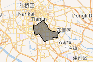
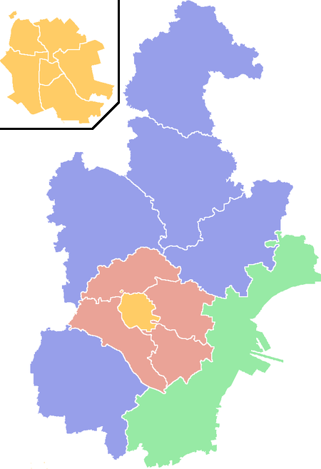
Hexi District, Tianjin
Hexi District (simplified Chinese: 河西区; traditional Chinese: 河西區; pinyin: Héxī Qū; lit.: 'west of the (Hai) River")' is a district in the south-western corner of urban Tianjin, People's Republic of China. It is bordered by Heping District in the north-west, Hedong District to the north-east and Nankai District to the west.
Hexi 河西区 | ||||||||||||||||||||||||||||||||||||||||||||||||
|---|---|---|---|---|---|---|---|---|---|---|---|---|---|---|---|---|---|---|---|---|---|---|---|---|---|---|---|---|---|---|---|---|---|---|---|---|---|---|---|---|---|---|---|---|---|---|---|---|
District | ||||||||||||||||||||||||||||||||||||||||||||||||
 Tianjin Amusement Park within Hexi District | ||||||||||||||||||||||||||||||||||||||||||||||||
| ||||||||||||||||||||||||||||||||||||||||||||||||
| Coordinates (Hexi government): 39°06′34″N 117°13′24″E | ||||||||||||||||||||||||||||||||||||||||||||||||
| Country | People's Republic of China | |||||||||||||||||||||||||||||||||||||||||||||||
| Municipality | Tianjin | |||||||||||||||||||||||||||||||||||||||||||||||
| Township-level divisions | 13 subdistricts | |||||||||||||||||||||||||||||||||||||||||||||||
| Area | ||||||||||||||||||||||||||||||||||||||||||||||||
| • Total | 37 km2 (14 sq mi) | |||||||||||||||||||||||||||||||||||||||||||||||
| Time zone | UTC+8 (China Standard) | |||||||||||||||||||||||||||||||||||||||||||||||
| Tianjin district map |
| |||||||||||||||||||||||||||||||||||||||||||||||
| Website | www | |||||||||||||||||||||||||||||||||||||||||||||||
Administrative divisions
There are 13 subdistricts in the district:[1]
| Name | Chinese (S) | Hanyu Pinyin | Population (2010)[2] | Area (km2) |
|---|---|---|---|---|
| Dayingmen Subdistrict | 大营门街道 | Dàyíngmén Jiēdào | 28,358 | 0.99 |
| Xiawafang Subdistrict | 下瓦房街道 | Xiàwǎfáng Jiēdào | 49,767 | 1.693 |
| Taoyuan Subdistrict | 桃园街道 | Táoyuán Jiēdào | 51,061 | 1.4 |
| Guajiasi Subdistrict | 挂甲寺街道 | Guàjiǎsì Jiēdào | 88,190 | 2.63 |
| Machang Subdistrict | 马场街道 | Mǎchǎng Jiēdào | 54,949 | 4.12 |
| Yuexiu Road Subdistrict | 越秀路街道 | Yuèxiùlù Jiēdào | 76,409 | 3.69 |
| Youyi Road Subdistrict | 友谊路街道 | Yǒuyìlù Jiēdào | 77,883 | 2.87 |
| Tianta Subdistrict | 天塔街道 | Tiāntǎ Jiēdào | 83,753 | 3.28 |
| Jianshan Subdistrict | 尖山街道 | Jiānshān Jiēdào | 91,767 | 6.36 |
| Chentangzhuang Subdistrict | 陈塘庄街道 | Chéntángzhuāng Jiēdào | 59,256 | 5.9 |
| Liulin Subdistrict | 柳林街道 | Liǔlín Jiēdào | 101,679 | 4.2 |
| Donghai Subdistrict | 东海街道 | Dōnghǎi Jiēdào | 80,013 | 2.12 |
| Meijiang Subdistrict | 梅江街道 | Méijiāng Jiēdào | 27,547 | 2.6 |
Transportation
Metro
Hexi is currently served by two metro lines operated by Tianjin Metro:

Educational institutions
Major secondary schools
- Tianjin Experimental High School
- Tianjin Haihe High School
- Tianjin High School Affiliated to Beijing Normal University
- Tianjin No.4 High School
- Tianjin No.41 High School
- Tianjin No.42 High School
- Tianjin Xinhua High School
International schools
Attractions
- Tianjin Amusement Park
- Tianjin Grand Theatre
- Jiefang South Park
- People's Park
Footnotes
- 2011年统计用区划代码和城乡划分代码:河西区 (in Chinese). National Bureau of Statistics of the People's Republic of China. Archived from the original on 2012-10-01. Retrieved 2013-08-08.
- Census Office of the State Council of the People's Republic of China; Population and Employment Statistics Division of the National Bureau of Statistics of the People's Republic of China (2012). 中国2010人口普查分乡、镇、街道资料 (1 ed.). Beijing: China Statistics Print. ISBN 978-7-5037-6660-2.
| ||
| Districts |  | |
| Defunct Districts | ||
| Authority control |
|
|---|
This article is issued from Wikipedia. The text is licensed under Creative Commons - Attribution - Sharealike. Additional terms may apply for the media files.