Muzaffarabad
Muzaffarabad (Urdu: مُظفّر آباد) is the capital of the Pakistan-administered territory of Azad Jammu and Kashmir.
Muzaffarabad مُظفّر آباد | |
|---|---|
City | |
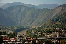
 The city is situated in a valley formed by the confluence of the Neelam and Jhelum rivers | |
 Muzaffarabad  Muzaffarabad | |
| Coordinates: 34°21′30″N 73°28′20″E | |
| Country | |
| Territory | |
| Area | |
| • City | 1,642 km2 (634 sq mi) |
| Elevation | 737 m (2,418 ft) |
| Population | |
| • City | 149,913 |
| • Density | 58.47/km2 (151.4/sq mi) |
| Time zone | UTC+05:00 (PST) |
| Calling code | 05822 |
| Website | Muzaffarabad Local Government |
The city is located in Muzaffarabad District near the confluence of the Jhelum and Neelum rivers. The district is bounded by the province of Khyber-Pakhtunkhwa in the west, by the Kupwara and Baramulla districts of Indian-administered Jammu and Kashmir in the east, and the Neelum District of Azad Kashmir in the north.
History
Muzaffarabad was founded in 1646 by Sultan Muzaffar Khan chief of the Bomba.[1] [2] which ruled Kashmir.[3] Sultan Muzaffar Khan also completed Muzaffarabad's Red Fort that same year to ward off incursions from the Mughal Empire.
2005 Earthquake

The city was near the epicenter of the 2005 Kashmir earthquake, which had a magnitude of 7.6. The earthquake destroyed about 50% of the buildings in the city (including most of the official buildings) and is estimated to have killed up to 80,000 people in the Pakistani-controlled areas of Kashmir. As of 8 October 2005 the Pakistani government's official death toll was 87,350. Some estimates put the death toll over 100,000.[4]
Administrative divisions

The district of Muzaffarabad is administratively subdivided into 02 tehsils, which are sub-divided into 25 Union Councils[5]
- Muzaffarabad
- Pattika (Naseerabad)
Climate
| Climate data for Muzaffarabad (1961–2009) | |||||||||||||
|---|---|---|---|---|---|---|---|---|---|---|---|---|---|
| Month | Jan | Feb | Mar | Apr | May | Jun | Jul | Aug | Sep | Oct | Nov | Dec | Year |
| Record high °C (°F) | 27.0 (80.6) |
29.4 (84.9) |
37.0 (98.6) |
40.5 (104.9) |
46.5 (115.7) |
46.2 (115.2) |
45.0 (113.0) |
40.2 (104.4) |
39.0 (102.2) |
38.3 (100.9) |
33.0 (91.4) |
27.0 (80.6) |
46.5 (115.7) |
| Average high °C (°F) | 16.0 (60.8) |
18.0 (64.4) |
22.6 (72.7) |
28.3 (82.9) |
33.5 (92.3) |
37.4 (99.3) |
34.9 (94.8) |
34.0 (93.2) |
33.4 (92.1) |
30.1 (86.2) |
24.2 (75.6) |
18.1 (64.6) |
22.3 (72.1) |
| Average low °C (°F) | 3.1 (37.6) |
5.4 (41.7) |
9.7 (49.5) |
14.2 (57.6) |
18.4 (65.1) |
21.9 (71.4) |
22.8 (73.0) |
22.6 (72.7) |
19.4 (66.9) |
13.7 (56.7) |
7.8 (46.0) |
4.1 (39.4) |
11.1 (52.0) |
| Record low °C (°F) | −3.0 (26.6) |
−1.1 (30.0) |
1.0 (33.8) |
6.5 (43.7) |
7.0 (44.6) |
12.0 (53.6) |
15.5 (59.9) |
16.0 (60.8) |
12.4 (54.3) |
6.5 (43.7) |
1.0 (33.8) |
−1.4 (29.5) |
−3 (27) |
| Average rainfall mm (inches) | 101.3 (3.99) |
137.4 (5.41) |
157.3 (6.19) |
109.0 (4.29) |
78.5 (3.09) |
113.6 (4.47) |
328.7 (12.94) |
229.9 (9.05) |
112.6 (4.43) |
45.9 (1.81) |
37.2 (1.46) |
69.0 (2.72) |
1,242.8 (48.93) |
| Average relative humidity (%) (at 12:00 PST) | 50.3 | 46.3 | 40.9 | 38.0 | 33.2 | 34.0 | 52.2 | 57.6 | 48.1 | 42.4 | 48.4 | 54.0 | 37.2 |
| Source: Pakistan Meteorological Department[6] | |||||||||||||
Transport
The closest railway stations are [Rawalpindi] in Pakistan and Baramulla in the Indian state of Jammu and Kashmir.[7]
Notable People
- Anam Najam, medical doctor and psychiatrist
See also
References
- "Statistical Year Book 2019" (PDF). Statistics Azad Jammu and Kashmir. Retrieved 20 April 2020.
- Mir-át-i Mas'údi Archived 2007-09-29 at the Wayback Machine
- Ahmad, Pirzada Irshad (2003). A Hand Book on Azad Jammu & Kashmir. Nawab Sons Publication. ISBN 978-969-530-050-3.
- Stuart, Julia. (1 January 2006) IoS Appeal: Last chance to donate to quake victims Archived 16 January 2006 at the Wayback Machine. News.independent.co.uk. Retrieved on 3 July 2012.
- Information about SPs District Muzaffarabad Archived 6 November 2007 at the Wayback Machine
- "Muzaffarabad Climate Data". Pakistan Meteorological Department. Archived from the original on 13 June 2010. Retrieved 1 October 2019.
- Google Maps. Maps.google.co.uk. Retrieved on 3 July 2012.
External links
| Wikivoyage has a travel guide for Muzaffarabad. |
| Wikimedia Commons has media related to Muzaffarabad. |
| History |
|
|---|---|
| Modern history |
|
| Government and politics |
|
| Culture and places | |
| Geography | |
| Districts | |
| Cities & Town | |
| Economy | |
| Education |
|
| Sport |
|
| Others |
|
| Mirpur |
| ||||||||
|---|---|---|---|---|---|---|---|---|---|
| Muzaffarabad |
| ||||||||
| Poonch |
| ||||||||