Municipality of the District of Argyle
Argyle, officially named the Municipality of the District of Argyle, is a district municipality in Yarmouth County, Nova Scotia. Statistics Canada classifies the district municipality as a municipal district.
Argyle | |
|---|---|
District municipality | |
| Municipality of the District of Argyle Municipalité du district d'Argyle | |
 Flag  Seal | |
| Motto(s): Industry | |
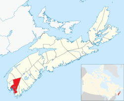 Location of the Municipality of the District of Argyle | |
| Coordinates: 43°48′N 65°51′W | |
| Country | |
| Province | |
| County | Yarmouth |
| Incorporated | April 17, 1879 |
| Electoral Districts Federal | West Nova |
| Provincial | Argyle-Barrington |
| Government | |
| • Type | Argyle Municipal Council |
| • Municipal Seat | Tusket |
| • Warden | Richard Donaldson |
| • Deputy Warden | Danny Muise |
| • Councillors | List of Members
|
| • MLA MP | Chris d'Entremont (PC) Colin Fraser (L) |
| Area | |
| • Land | 1,528.17 km2 (590.03 sq mi) |
| Population | |
| • Total | 7,899 |
| • Density | 5.2/km2 (13/sq mi) |
| • Change 2011-16 | |
| Time zone | UTC-4 (AST) |
| • Summer (DST) | UTC-3 (ADT) |
| Area code(s) | 902 |
| Dwellings | 3,821 |
| Median Income* | $49,898 CDN |
| Website | www |
| |
The district municipality occupies the eastern portion of the county and is one of three municipal units - the other two being the Town of Yarmouth and the Municipality of the District of Yarmouth. Argyle is a bilingual community, in which native speakers of English and French each account for about half of the population. As of 2016, 60% of the population speaks both French and English, one of the highest rates of bilingualism in Canada.[3]
History
Originally inhabited by the Mi'kmaq, it was called "Bapkoktek".[4] In 1766, after his service in the French and Indian Wars, Lt. Ranald MacKinnon was given a land grant of 2,000 acres (8.1 km2). He called it Argyle (Argyll) because he was reminded of his previous home in the Highlands of Scotland.[4] The township was granted in 1771.[4]
Demographics
In the 2016 Census of Population conducted by Statistics Canada, the Municipality of the District of Argyle recorded a population of 7,899 living in 3,362 of its 3,821 total private dwellings, a change of -4.3% from its 2011 population of 8,252. With a land area of 1,528.17 km2 (590.03 sq mi), it had a population density of 5.2/km2 (13.4/sq mi) in 2016.[5]
| Ethnic Origin | Population | Pct (%) |
|---|---|---|
| Canadian | 4,605 | 53.6% |
| French | 4,395 | 51.1% |
| English | 2,065 | 24.0% |
| Acadian | 1,290 | 15.0% |
| Métis | 1,255 | 14.6% |
| Irish | 880 | 10.2% |
| Scottish | 880 | 10.2% |
| North American Indian | 530 | 6.2% |
| German | 265 | 3.1% |
| Language | Population | Pct (%) |
|---|---|---|
| English only | 4,295 | 52.28% |
| French only | 3,725 | 45.34% |
| Both English and French | 160 | 1.95% |
| Other languages | 35 | 0.43% |
| Religion | Population | Pct (%) |
|---|---|---|
| Catholic | 5,435 | 67.06% |
| No religious affiliation | 965 | 11.91% |
| Baptist | 925 | 11.41% |
| Other Christian | 500 | 6.17% |
| Anglican | 140 | 1.73% |
| United Church | 70 | 0.86% |
| Pentecostal | 70 | 0.86% |
| Historical population | |||||||||||||||||||||||||||||||||||||||||||
|---|---|---|---|---|---|---|---|---|---|---|---|---|---|---|---|---|---|---|---|---|---|---|---|---|---|---|---|---|---|---|---|---|---|---|---|---|---|---|---|---|---|---|---|
|
| ||||||||||||||||||||||||||||||||||||||||||
| [8][9] | |||||||||||||||||||||||||||||||||||||||||||
Education:
- No certificate, diploma or degree: 41.64%
- High school certificate: 16.38%
- Apprenticeship or trade certificate or diploma: 14.16%
- Community college, CEGEP or other non-university certificate or diploma: 19.36%
- University certificate or diploma: 8.40%
Unemployment rate:
- 10.7%
Average house value:
- $147,574
Communities
- Amiraults Hill
- Argyle
- Argyle Sound
- Central Argyle
- Comeau's Hill
- East Kemptville
- East Pubnico
- East Quinan
- Glenwood
- Hubbard's Point
- Lower Argyle
- Lower East Pubnico
- Lower Eel Brook
- Lower Wedgeport
- Lower West Pubnico
- Middle East Pubnico
- Middle West Pubnico
- Morris Island
- North Belleville
- Plymouth
- Pubnico
- Quinan
- Sluice Point
- South Belleville
- Ste. Anne du Ruisseau
- Surette's Island
- Tusket
- Tusket Falls
- Tusket Islands
- Upper Wedgeport
- Wedgeport
- West Pubnico
References
- Statistics Canada. "Population and dwelling counts, for Canada, provinces and territories, and census subdivisions (municipalities), 2011 and 2006 censuses". Retrieved 2015-06-21.
- Statistics Canada Population and dwelling counts, for Canada and census subdivisions (municipalities), 2016 censuses - 100% data
- Western Regional Enterprise Network
- Brown, Thomas J. (1922). Place-names of the Province of Nova Scotia. Halifax, Nova Scotia: Royal Print & Litho. p. 11.
- "Population and dwelling counts, for Canada, provinces and territories, and census subdivisions (municipalities), 2016 and 2011 censuses – 100% data (Nova Scotia)". Statistics Canada. February 8, 2017. Retrieved February 12, 2017.
- 2006 Statistics Canada Census Ethnocultural Portrait of Canada: Argyle Municipal District, Nova Scotia
- Statistics Canada National Household Survey, for Municipality of Yarmouth, 2011 census - 100% data
- Statistics Canada: 1996, 2001, 2006 census
- Town of Yarmouth (January 10, 2008). Municipal Planning Strategy (Report). Town of Yarmouth. p. 7.
External links
| Wikimedia Commons has media related to Argyle Municipal District. |
Places adjacent to Municipality of the District of Argyle | ||||||||||
|---|---|---|---|---|---|---|---|---|---|---|
| ||||||||||
| Historical counties | |
|---|---|
| Economic regions | |
| Regional municipalities | |
| County municipalities | |
| District municipalities | |
| Towns | |
| Villages | |
| Lists | |
| |