Whakapapa skifield
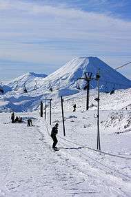
Whakapapa skifield is a commercial skifield on the northern side of Mount Ruapehu in Tongariro National Park, New Zealand. It is one of two skifields on the mountain, the other being Turoa, which is on Ruapehu's south-western slopes. The ski season is generally from late June to late October, depending on snow and weather conditions. The terrain at Whakapapa Skifield is divided up as 25% beginner, 50% intermediate and 25% advanced.
| Whakapapa Skifield | |
|---|---|
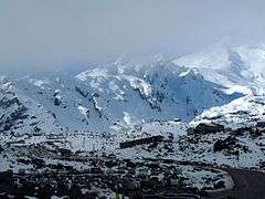 View from car park | |
 Whakapapa Skifield Whakapapa skifield is in the Manawatū-Whanganui region | |
| Location | Mt. Ruapehu, Tongariro National Park, New Zealand |
| Coordinates | 39.23736°S 175.55696°E |
| Top elevation | 2,300 m (7,546 ft) |
| Base elevation | 1,630 m (5,348 ft) |
| Skiable area | 1360 acres (550 ha) |
| Runs | 67 named |
| Lift system | 12 lifts: 1 Detachable Gondola 5 chairs (1 High-Speed Quad, 2 Quad, 2 Double), 3 Magic carpet, 3 T-Bars (Capacity 15,000ph) |
| Website | http://www.mtruapehu.com/ |
Access to the skifield is by Bruce Road, a two-lane, 6 km (3.7 mi) sealed road. Limited accommodation and refreshments are available at the entry to the skifield, and elsewhere on the mountain. Alpine huts are provided for trampers and climbers. Ruapehu's two skifields are collectively the largest ski resort in New Zealand. Turoa has a slightly longer season, generally opening a week before Whakapapa and closing early November. Both are operated by Ruapehu Alpine Lifts. Chateau Tongariro, which has appeared on several New Zealand stamps, is a feature of Whakapapa village.
Happy Valley
Happy Valley is a large beginner's area at Whakapapa separated from the rest of the skifield in its own little valley and is considered one of the best in the country. The area has a cafe and ski hire facility, there is also a double chair lift, and 4 magic carpet lifts including a dedicated snow sledding area. Access to Happy Valley is by way of two glass-enclosed 26 person elevators which travel 22m down into the canyon.
Lifts
There is a new lift systems that has been proposed. The Knoll ridge Express will replace the Knoll Ridge T-Bar and possible the valley t-bar as well, starting from the top of the rangatira express and ending in a similar spot to where the knoll ridge t-bar's top terminal is. If the plan goes ahead it will be a six seater with a top speed of 5 meters per second and the ability to transport 3,200 people per hour. A new gondola was installed for the 2019 season, called the Sky Waka, that can transport over 3000 people an hour from the base area at an elevation of 1630m to the Knoll Ridge Cafe at 2020m to provide access to the upper mountain.
| Lift Name | Type | Ride Time | Vertical Rise |
|---|---|---|---|
| Double Happy Chair | Double | 4 min | 30m |
| Happy Valley Chair | Double | 1 min | 15m |
| Happy Valley Magic Carpet | Magic Carpet | 3 min | 15m |
| Rangatira Express | Detachable Quad | 3 min | 130m |
| West Ridge Quad | Quad | 11 min | 230m |
| Sky Waka Gondola | Gondola | 8 min | 390m |
| Delta Quad | Quad fixed grip chair | 5 min | 130m |
| Knoll Ridge T-Bar | T-Bar | 10 min | 250m |
| Valley T-Bar | T-Bar | 8 min | 190m |
| Far West T-Bar | T-Bar | 10 min | 315m |
2009 arson attacks
On 13 February 2009 arson destroyed two buildings at the skifield:[1] the main chalet and an implement shed containing three snow groomers. The damage was estimated at $11 to 12.5 million.[2] The main chalet, the Knoll Ridge Cafe was replaced by a new, more modern, facility slightly lower down the mountain with less visual impact than the old chalet.
Weather
Weather conditions can be changeable over the day, and mountain visitors are advised to be prepared and carry basic survival equipment. Although severe weather is unusual and generally forecast, it has claimed several lives over the years, including a party of soldiers undergoing winter survival training in 1990. The same storm also trapped a Japanese tourist when the weather unexpectedly closed in on him, but he built a snow cave and sheltered in it until he was rescued days later.
On July 5, 2003 about 350 skiers and 70 skifield staff were trapped on the mountain overnight at Top o'the Bruce when a sudden snow storm blew up and within a few minutes made the access road too dangerous to descend. They spent the night in relative comfort and all descended safely the next morning. Such rapidly changing conditions are typical of the weather on New Zealand mountains. Again on Saturday July 26, 2008 skiers and staff were trapped on the mountain overnight when a fast approaching storm caused the skifield to be closed at 10:30am and made the road too dangerous for cars without chains or 4WD to leave the area. By 3pm there were still over 100 cars in the Whakapapa car park and those who had not been able to leave by that point were told to settle in for the night. All cars were able to leave safely the next morning.
Whakapapa Village climate
Whakapapa Village, within 10 minutes of the skifield, has mild summers with max summer temperatures around 20, and very cold winters for NZ standards with snow falling on some days, with an elevation just shy of 1200 meters. The average daytime high in July is 6 degrees, compared to the 17 in February. Severe frosts occur frequently in the winter months. Whakapapa is a very wet place, with over 2000mm of rain accumulating annually.
Iwikau climate
Being more than 400 metres higher than Whakapapa Village, Iwikau is considerably cooler year-round with an average annual temperature of 5.5 °C. Maximum temperatures vary from 16.6 °C in February to 3.6 °C in July. Minimum temperatures range from 5.2 °C in February to -3.1 °C in July. The climate is classified as Cfc, or sub-polar oceanic. The driest month is February, with 196 mm of precipitation, and the wettest month is July, with 399 mm of precipitation. Annually, 3733 mm of precipitation falls on Iwikau.
| Climate data for Iwikau, 1626 m | |||||||||||||
|---|---|---|---|---|---|---|---|---|---|---|---|---|---|
| Month | Jan | Feb | Mar | Apr | May | Jun | Jul | Aug | Sep | Oct | Nov | Dec | Year |
| Average high °C (°F) | 16.4 (61.5) |
16.6 (61.9) |
14.2 (57.6) |
10.8 (51.4) |
7.2 (45.0) |
4.6 (40.3) |
3.6 (38.5) |
4.4 (39.9) |
6.6 (43.9) |
9.4 (48.9) |
11.8 (53.2) |
14.3 (57.7) |
10.0 (50.0) |
| Daily mean °C (°F) | 10.7 (51.3) |
10.9 (51.6) |
9.1 (48.4) |
6.3 (43.3) |
3.3 (37.9) |
1.2 (34.2) |
0.2 (32.4) |
0.9 (33.6) |
2.8 (37.0) |
5.0 (41.0) |
6.8 (44.2) |
9.0 (48.2) |
5.5 (41.9) |
| Average low °C (°F) | 5.1 (41.2) |
5.2 (41.4) |
4.1 (39.4) |
1.8 (35.2) |
−0.5 (31.1) |
−2.1 (28.2) |
−3.1 (26.4) |
−2.5 (27.5) |
−1 (30) |
0.6 (33.1) |
1.9 (35.4) |
3.8 (38.8) |
1.1 (34.0) |
| Average rainfall mm (inches) | 236.0 (9.29) |
196.0 (7.72) |
283.0 (11.14) |
281.0 (11.06) |
353.0 (13.90) |
383.0 (15.08) |
399.0 (15.71) |
383.0 (15.08) |
362.0 (14.25) |
302.0 (11.89) |
265.0 (10.43) |
290.0 (11.42) |
3,733 (146.97) |
| Source: Climate-data.org[3] | |||||||||||||
Other activities
Tubing At Whakapapa
Across from Happy Valley is a tubing park called 'the sliding zone'. It is a large area dedicated to tubing, and within walking distance from the base area.
Guided Crater Lake Walks
Offered in the summer months of the year, there is an option to view the volcanic crater lake at the top of the mountain. Visitors take a chairlift ride up to 2020m, from which a guide takes visitors on a 6-hour walk around the lake.
References
- "Building a picture of ski field arsonists". New Zealand Police. 19 February 2009. Retrieved 2009-02-19.
- Simons, Louis (1 June 2009). "Uphill start for Ruapehu skiing". The New Zealand Herald. Retrieved 2009-10-09.
- "Climate-data.org – Climate Data for Cities Worldwide". openstreetmap.org. Retrieved 9 March 2020.