Mongpong
Mongpong is a village in the Kalimpong I CD block in the Kalimpong subdivision of the Kalimpong district of West Bengal, India.
Mongpong | |
|---|---|
Village | |
 Mongpong Location in West Bengal, India  Mongpong Mongpong (India) | |
| Coordinates: 26.8776°N 88.5022°E | |
| Country | |
| State | West Bengal |
| District | Kalimpong |
| Government | |
| • Body | Gram panchayat |
| Population (2011) | |
| • Total | 1,111 |
| Languages | |
| • Official | Nepali, Bengali, English |
| Time zone | UTC+5:30 (IST) |
| ISO 3166 code | IN-WB |
| Vehicle registration | WB |
| Nearest city | Malbazar |
| Website | kalimpongdistrict |
Geography
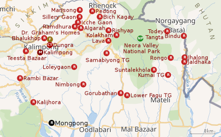 |
| Places in the Kalimpong Sadar subdivision in Kalimpong district CT: census town, R: rural/ urban centre, M: municipality, F: facility, NP: national park Abbreviations used in names – TG for Tea Garden (town/village) Owing to space constraints in the small map, the actual locations in a larger map may vary slightly |
Location
Mongpong is located at 26.8776°N 88.5022°E.
Area overview
The map alongside shows the Kalimpong Sadar subdivision of Kalimpong district. Physiographically, this area forms the Kalimpong Range, with the average elevation varying from 300 to 3,000 metres (980 to 9,840 ft). This region is characterized by abruptly rising hills and numerous small streams.[1]It is a predominantly rural area with 77.67% of the population living in rural areas and only 22.23% living in the urban areas. While Kalimpong is the only municipality, Dungra is the sole census town in the entire area.[2] The economy is agro-based and there are 6 tea gardens in the Gorubathan CD block.[3]In 2011, Kalimpong subdivision had a literacy rate of 81.85%, comparable with the highest levels of literacy in the districts of the state.[4][5]While the first degree college in the subdivision was established at Kalimpong in 1962[6]the entire subdivision (and now the entire district), other than the head-quarters, had to wait till as late as 2015 (more than half a century) to have their first degree colleges at Pedong and Gorubathan.[7][8]
Note: The map alongside presents some of the notable locations in the subdivision. All places marked in the map are linked in the larger full screen map.
The place
This village is located on the bank of Teesta river. The Teesta river breaks into several streams here. Mongpong is located on the fringe of Mahananda Wildlife Sanctuary and is home to several birds like brahminy duck, pintail duck, poachard, mallard and bar-headed goose that come here from Central Asia and Ladakh during winter. It is known for its beautiful landscape of the Teesta river, mountains and forests, which attract a lot of tourists. Accommodation is available at the Mongpong Forest Rest House managed by the West Bengal Forest Development Corporation (WBFDC).
Mongpong is attractively beautiful due to its ashtonishing landscapes and serene ambiance. The tourist attraction in and around Mongpong are Kalijhora, Chapramari Wildlife Sanctuary, Odlabari, Lataguri Wildlife Sanctuary, etc. Moreover, this is an ideal destination for adventure seekers as it offers trekking, hiking, bird watching, etc.
Demographics
According to the 2011 Census of India, Mongpong Forest had a total population of 1,111 of which 598 (54%) were males and 513 (46%) were females. There were 151 persons in the age range of 0 to 6 years. The total number of literate people in Mongpong Forest was 668 (69.58% of the population over 6 years).[9]
References
- "District Census Handbook, Darjeeling, Series 20, Part XII A, 2011 Census of India" (PDF). Page 13: Physiography. Directorate of Census Operations, West Bengal. Retrieved 6 April 2020.
- "District Statistical Handbook 2013 Darjeeling". Table 2.4b. Department of Statistics and Programme Implementation, Government of West Bengal. Retrieved 6 April 2020.
- "About Kalimpong District". Tea Gardens. District administration. Retrieved 6 April 2020.
- "District Statistical Handbook 2013 Darjeeling". Table 4.5. Department of Statistics and Programme Implementation, Government of West Bengal. Retrieved 6 April 2020.
- "Provisional Population Totals Paper 1 of 2011 : West Bengal". Statement-4 Ranking of Districts by Literacy Rate in 2001 and 2011. Office of the Registrar General and & Census Commissioner, India, Ministry of Home Affairs, Government of India. Retrieved 20 June 2012.
- "Kalimpong College". College Admission. Retrieved 6 April 2020.
- "Government General Degree College at Pedong". GGDC. Retrieved 6 April 2020.
- "Government General Degree College, Gorubathan". GGDC. Retrieved 6 April 2020.
- "2011 Census – Primary Census Abstract Data Tables". West Bengal – District-wise. Registrar General and Census Commissioner, India. Retrieved 1 April 2020.
External Links
Cities, towns and locations in Kalimpong District | |
|---|---|
| Cities, municipal and census towns | |
| Locations other than cities and towns |
|
| See also |
|