Algarah
Algarah (also known as Algarah Bazar) is a village in Kalimpong II CD block in the Kalimpong subdivision of the Kalimpong district of West Bengal, India.
Algarah Algarah Bazar | |
|---|---|
Village | |
 Algarah Location in West Bengal, India | |
| Coordinates: 27.1178°N 88.5836°E | |
| Country | |
| State | West Bengal |
| District | Kalimpong |
| Elevation | 1,780 m (5,840 ft) |
| Population (2011) | |
| • Total | 1,957 |
| Languages | |
| • Official | Nepali, Bengali, English |
| Time zone | UTC+5:30 (IST) |
| PIN | 734 314 |
| Telephone code | 03552 |
| Vehicle registration | WB-78, 79 |
| Website | kalimpongdistrict |
Geography
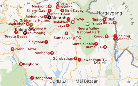 |
| Places in the Kalimpong Sadar subdivision in Kalimpong district CT: census town, R: rural/ urban centre, M: municipality, F: facility, NP: national park Abbreviations used in names – TG for Tea Garden (town/village) Owing to space constraints in the small map, the actual locations in a larger map may vary slightly |
Location
Algarah is located at 27.1178°N 88.5836°E
It is located at a distance of 15 km east of Kalimpong town. It lies at an elevation of 1,780 m (5,840 ft) and has a population of about 3,000.
Area overview
The map alongside shows the Kalimpong Sadar subdivision of Kalimpong district. Physiographically, this area forms the Kalimpong Range, with the average elevation varying from 300 to 3,000 metres (980 to 9,840 ft). This region is characterized by abruptly rising hills and numerous small streams.[1] It is a predominantly rural area with 77.67% of the population living in rural areas and only 22.23% living in the urban areas. While Kalimpong is the only municipality, Dungra is the sole census town in the entire area.[2] The economy is agro-based and there are 6 tea gardens in the Gorubathan CD block.[3] In 2011, Kalimpong subdivision had a literacy rate of 81.85%, comparable with the highest levels of literacy in the districts of the state.[4][5] While the first degree college in the subdivision was established at Kalimpong in 1962[6]the entire subdivision (and now the entire district), other than the head-quarters, had to wait till as late as 2015 (more than half a century) to have their first degree colleges at Pedong and Gorubathan.[7][8]
Note: The map alongside presents some of the notable locations in the subdivision. All places marked in the map are linked in the larger full screen map.
Demographics
According to the 2011 Census of India, Algarah Bazer DIF had a total population of 1,957 of which 982 (50%) were males and 975 (50%) were females. There were 182 persons in the age range of 0 to 6 years. The total number of literate people in Algarah Bazer DIF was 1,449 (81.63% of the population over 6 years).[9]
Civic administration
CD block HQ
Headquarters of Kalimpong II CD block is at Algarah Bazar.[10]
History
Algarah is famous for the remains of the ancient Damsang Gadi (Damsang Fort). It is said that the Lepcha king Gyabo Achuk built this fort in 1690 with the help of spirits who brought big round smooth stones from the Reshi river. And the remnants of the fort still do exist. There have been many stories passed from generation to generation about King Gaybo Achuk. It was believed that he used to possess some kind of supernatural powers. There are stories about some hidden treasures guarded by some kind of supernatural forces and also tunnels build by Gyabo Achuk. The fort was initially built to fight the Drukpas of Bhutan. There are many myths about Drukpas fearing to visit the place as it was believed that King Gaybo Achuk was killed by the Drukpa king by forgery. It is said that King Gyabo Achuk used to practice some ancient magic, wherein if his body was cut into two pieces, they would automatically rejoin. So the Drukpa king came up with a plan and lured him into it. The Drukpa king chopped off his head from his body and applied ashes on his half-cut neck so it could not be rejoined, finally resulting in the death of the Lepcha king. It is believed that any Drukpa visiting that place will be struck to death due to some supernatural force.
The fort was later used to ward off the forces of the British East India Company. The fort fell into ruin after the 1864 Anglo-Bhutan War. Every year on 20 December, Lepchas from all the adjoining regions (Kalimpong, Darjeeling, Sikkim) come to Damsang Fort to celebrate the birthday of King Gyabo Achuk and to attend some auspicious rituals that is followed from generation to generation by the Lepcha tribes.
Healthcare
There is a primary health centre, with 2 beds, at Algarah.[11]
References
- "District Census Handbook, Darjeeling, Series 20, Part XII A, 2011 Census of India" (PDF). Page 13: Physiography. Directorate of Census Operations, West Bengal. Retrieved 6 April 2020.
- "District Statistical Handbook 2013 Darjeeling". Table 2.4b. Department of Statistics and Programme Implementation, Government of West Bengal. Retrieved 6 April 2020.
- "About Kalimpong District". Tea Gardens. District administration. Retrieved 6 April 2020.
- "District Statistical Handbook 2013 Darjeeling". Table 4.5. Department of Statistics and Programme Implementation, Government of West Bengal. Retrieved 6 April 2020.
- "Provisional Population Totals Paper 1 of 2011 : West Bengal". Statement-4 Ranking of Districts by Literacy Rate in 2001 and 2011. Office of the Registrar General and & Census Commissioner, India, Ministry of Home Affairs, Government of India. Retrieved 20 June 2012.
- "Kalimpong College". College Admission. Retrieved 6 April 2020.
- "Government General Degree College at Pedong". GGDC. Retrieved 6 April 2020.
- "Government General Degree College, Gorubathan". GGDC. Retrieved 6 April 2020.
- "2011 Census – Primary Census Abstract Data Tables". West Bengal – District-wise. Registrar General and Census Commissioner, India. Retrieved 1 April 2020.
- "District Census Handbook: Darjiling" (PDF). Map of District Darjiling with CD block HQs and Police Stations (on the fifth page). Directorate of Census Operations, West Bengal, 2011. Retrieved 1 April 2020.
- "Health & Family Welfare Department" (PDF). Health Statistics – Primary Health Centres. Government of West Bengal. Retrieved 3 April 2020.
Cities, towns and locations in Kalimpong District | |
|---|---|
| Cities, municipal and census towns | |
| Locations other than cities and towns |
|
| See also |
|