Kalijhora
Kalijhora is a village in the Kalimpong I CD block in the Kalimpong Sadar subdivision of the Kalimpong district in the state of West Bengal, India.
Kalijhora | |
|---|---|
Village | |
 Kalijhora Location in West Bengal, India  Kalijhora Kalijhora (India) | |
| Coordinates: 26.9236°N 88.4512°E | |
| Country | |
| State | West Bengal |
| District | Kalimpong |
| Time zone | UTC+5:30 (IST) |
| PIN | 734320 |
| Vehicle registration | WB |
| Lok Sabha constituency | Darjeeling |
| Vidhan Sabha constituency | Kalimpong |
| Website | kalimpong |
Geography
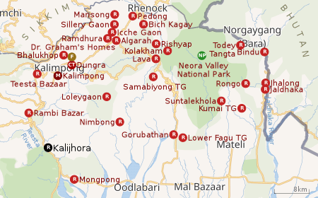 |
| Places in the Kalimpong Sadar subdivision in Kalimpong district CT: census town, R: rural/ urban centre, M: municipality, F: facility, NP: national park Abbreviations used in names – TG for Tea Garden (town/village) Owing to space constraints in the small map, the actual locations in a larger map may vary slightly |
Location
Kalijhora is located at 26.9232°N 88.4512°E.
Area overview
The map alongside shows the Kalimpong Sadar subdivision of Kalimpong district. Physiographically, this area forms the Kalimpong Range, with the average elevation varying from 300 to 3,000 metres (980 to 9,840 ft). This region is characterized by abruptly rising hills and numerous small streams.[1]It is an predominantly rural area with 77.67% of the population living in rural areas and only 22.23% living in the urban areas. While Kalimpong is the only municipality, Dungra is the sole census town in the entire area.[2] The economy is agro-based and there are 6 tea gardens in the Gorubathan CD block.[3]In 2011, Kalimpong subdivision had a literacy rate of 81.85%, comparable with the highest levels of literacy in the districts of the state.[4][5]While the first degree college in the subdivision was established at Kalimpong in 1962[6]the entire subdivision (and now the entire district), other than the head-quarters, had to wait till as late as 2015 (more than half a century) to have their first degree colleges at Pedong and Gorubathan.[7][8]
Note: The map alongside presents some of the notable locations in the subdivision. All places marked in the map are linked in the larger full screen map.
Economy
Teesta Low Dam IV power station is a “run of the river scheme with diurnal storage for peaking purpose.” There is a 45m high dam across the Teesta River and the surface power house has 4 x 40 MW units. All the four units were commissioned in 2017. The project was executed by NHPC Limited.[9][10][11]
Tourism
Kalijhora was earlier a popular picnic spot, which has been submerged by the low dam built for hydro power generation. There are several tourist destinations close to Kalijhora, such as Latpachar, Mangpu, Takdah, Chota and Bada Mangwa, Lamhatta and Peshok.[12]
References
- "District Census Handbook, Darjeeling, Series 20, Part XII A, 2011 Census of India" (PDF). Page 13: Physiography. Directorate of Census Operations, West Bengal. Retrieved 6 April 2020.
- "District Statistical Handbook 2013 Darjeeling". Table 2.4b. Department of Statistics and Programme Implementation, Government of West Bengal. Retrieved 6 April 2020.
- "About Kalimpong District". Tea Gardens. District administration. Retrieved 6 April 2020.
- "District Statistical Handbook 2013 Darjeeling". Table 4.5. Department of Statistics and Programme Implementation, Government of West Bengal. Retrieved 6 April 2020.
- "Provisional Population Totals Paper 1 of 2011 : West Bengal". Statement-4 Ranking of Districts by Literacy Rate in 2001 and 2011. Office of the Registrar General and & Census Commissioner, India, Ministry of Home Affairs, Government of India. Retrieved 2012-06-20.
- "Kalimpong College". College Admission. Retrieved 6 April 2020.
- "Government General Degree College at Pedong". GGDC. Retrieved 6 April 2020.
- "Government General Degree College, Gorubathan". GGDC. Retrieved 6 April 2020.
- "Teesta Low Dam IV". NHPC Limited. Retrieved 4 April 2020.
- "Teesta Low Dam IV Hydroelectric Project in India". Global Energy Observatory. Retrieved 4 April 2020.
- "NHPC completes Teesta Low Dam IV Hydro Project". ET Energy World, 19 August 2016. Retrieved 4 April 2020.
- "Kalijhora". North Bengal.com. Retrieved 4 April 2020.
Cities, towns and locations in Kalimpong District | |
|---|---|
| Cities, municipal and census towns | |
| Locations other than cities and towns |
|
| See also |
|