Milecastle 35
Milecastle 35 (Sewingshields) is one of the milecastles on Hadrian's Wall (grid reference NY80497018). The remains still exist as exposed masonry.
| Milecastle 35 | |
|---|---|
 Consolidated remains of Milecastle 35 | |
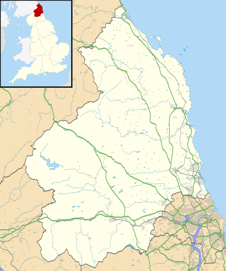 Location within Northumberland | |
| Type | Milecastle |
| Location | |
| Coordinates | 55.025812°N 2.306637°W |
| County | Northumberland |
| Country | England |
| Reference | |
| UK-OSNG reference | NY80497018 |
Description
The remains of Milecastle 35 are located on the east facing slope of Sewingshields Crags and survive as stone foundations. The milecastle measures 18.3 metres by 15.2 metres internally and its walls are up to 3.2 metres wide.[1] A Roman branch road running south from Milecastle 35 to join the Military Way survives as a low agger up to 5.5 metres wide and up to 20 centimetres high.[2]
Construction
Milecastle 35 was a long-axis milecastle with a Type IV gateway (south gate).[1]
Excavations
Milecastle 35 was excavated in 1947 and again between 1978 and 1980 (with an additional week in 1982).[1] Several phases of internal buildings were detected. Phase I consisted of a small building 4.25 metres by 7.45 metres with stone footings.[1] Phase II, probably dating to the late 2nd or early 3rd century, consisted of a new buildings on the east and west side. The site then fell into disrepair.[1] Phase III consisted of new buildings, somewhat crudely constructed, with considerable industrial activity.[1] Phase IV consisted of some new stone footings placed over previous metal-working areas.[1]
The site was reoccupied in the late-medieval period (13th to 16th century), when two substantial longhouse buildings were built.[3] The medieval remains were removed during excavations.[3]
Associated turrets


Each milecastle on Hadrian's Wall had two associated turret structures. These turrets were positioned approximately one-third and two-thirds of a Roman mile to the west of the Milecastle, and would probably have been manned by part of the nearest milecastle's garrison. The turrets associated with Milecastle 35 are known as Turret 35A and Turret 35B.
Turret 35A
Turret 35A (Sewingshields Crag) (grid reference NY80087008) exists as a consolidated structure.[4] The turret measures 3.7 metres by 2.4 metres internally, and the walls are up to 0.75 metres high.[4] It was excavated in 1958.[4] A rough inscribed slab was found 19 metres east of the Turret in the 1958 excavations.[4][5]
Turret 35B
Turret 35B (Busy Gap) (grid reference NY79906973) is at the top of the ridge before the descent into Busy Gap.[6] It was located in 1913 and excavated in 1946.[6] The excavations showed that the turret had narrow walls and a door to the east.[6] There are no visible remains above ground except for an earthwork platform measuring 3.8 metres by 5.5 metres and up to 0.5 metres high.[6]
Monument records
| Monument | Monument Number | English Heritage Archive Number |
| Milecastle 35 | 16829 | NY 87 SW 10 |
| Medieval buildings | 938892 | NY 87 SW 34 |
| Turret 35A | 16832 | NY 87 SW 11 |
| Inscribed slab | 952053 | NY 87 SW 36 |
| Turret 35B | 15134 | NY 76 NE 1 |
Public access
The milecastle, Turret 35A, and the site of Turret 35B, are all accessible via the Hadrian's Wall Path.
References
- MILECASTLE 35, Pastscape, retrieved 27 November 2013
- MONUMENT NO. 951794, Pastscape, retrieved 3 December 2013
- MONUMENT NO. 938892, Pastscape, retrieved 27 November 2013
- TURRET 35A, Pastscape, retrieved 27 November 2013
- MONUMENT NO. 952053, Pastscape, retrieved 3 December 2013
- TURRET 35B, Pastscape, retrieved 27 November 2013
External links
![]()
Forts and structures of Hadrian's Wall | ||
|---|---|---|
| Wall Forts (East to West) |  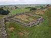 | |
| Outpost Forts | ||
| Stanegate Forts |
| |
| Supply Forts | ||
| Cumbrian Coast Forts (North to South) |
| |
| Milecastles | ||
| Milefortlets | ||
| Other structures on Hadrian's Wall | ||
| Regular and linear features | ||