Blatobulgium
Blatobulgium was a Roman fort, located at the modern-day site known as Birrens, in Dumfriesshire, Scotland.
Name
Blatobulgium is recorded in the Antonine Itinerary. The name derives from the Brittonic roots *blāto- 'bloom, blossom' or *blāto- (from earlier *mlāto-), 'flour' and *bolgo-, 'bag, bulge'. The name may mean 'flowery hillock' or 'flowery hollow'. However, as there are granaries at the fort, Blatobulgium may be a nickname meaning 'Flour Sacks'.[1]
_Roman_Fort_-_geograph.org.uk_-_2177289.jpg)
History
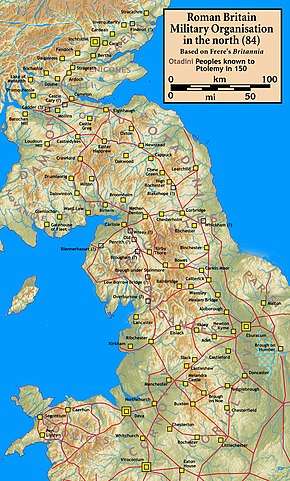
The fortress formed the northern terminus of the Roman-era Watling Street, Route 2 of the Antonine Itinerary. It was located in the territory of the Selgovae.
Finds
There have been more inscribed and sculptured stones found at Birrens than anywhere else in Scotland.[2] An altar stone dedicated to the Celtic goddess Ricagambeda was found at Birrens.[3]
References
- Rivet, A. L. F.; Smith, Colin (1981) [1979]. The Place-Names of Roman Britain. London: Book Club Associates. pp. 268–269.
- See also Rivet, A. L. F.; Jackson, Kenneth (1970). "The British Section of the Antonine Itinerary". Britannia. 1: 69. JSTOR 525833.
- The interpretations of the name are summarised by James, Alan G. (2014). The Brittonic Language in the Old North: A Guide to the Place-Name Evidence (PDF). Volume 2: Guide to the Elements. pp. 39, 42. Archived from the original (PDF) on 2014-09-11.
- Keppie, Lawrence (1994). "ROMAN INSCRIPTIONS AND SCULPTURE FROM BIRRENS: A REVIEW" (PDF). Transactions of the Dumfriesshire and Galloway Natural History and Antiquarian Society. 69: 35–51. Retrieved 9 July 2018.
- Hunter, Fraser; Carruthers, Martin. "ScARF Summary Roman Presence Report" (PDF). Scottish Heritage Hub. Retrieved 28 April 2018.
Forts and structures of Hadrian's Wall | ||
|---|---|---|
| Wall Forts (East to West) |  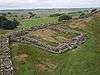 | |
| Outpost Forts | ||
| Stanegate Forts |
| |
| Supply Forts | ||
| Cumbrian Coast Forts (North to South) |
| |
| Milecastles | ||
| Milefortlets | ||
| Other structures on Hadrian's Wall | ||
| Regular and linear features | ||