Mexican War Streets
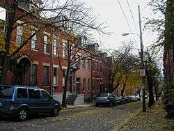
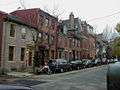
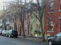
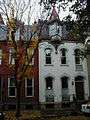
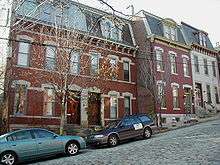
The Mexican War Streets, originally known as the "Buena Vista Tract", is a historic district in the Central Northside neighborhood of Pittsburgh, Pennsylvania, in the United States. The district is densely filled with restored row houses, community gardens, and tree-lined streets and alleyways. The area dates to around the time of the Mexican–American War. The 27-acre (11 ha) district was listed on the National Register of Historic Places in 1975 with 119 buildings deemed to contribute to the historic character of the district. In 2008, the district's listing was increased to include an additional 288 contributing buildings over a 25.7-acre (10.4 ha) area. As of 2020, the historic district has been expanded, with restrictions on facade remodels. [1]

Mexican War Streets Historic District | |
 | |
   | |
| Location | Irregular pattern between Buena Vista to the north and North Ave. to Reddour St. (increase), Pittsburgh, Pennsylvania |
|---|---|
| Coordinates | 40°27′21.23″N 80°0′41.40″W |
| Area | 27 acres (11 ha) (original) 25.7 acres (10.4 ha) (increase) |
| Architectural style | Late 19th and 20th Century Revivals, Greek Revival, Late Victorian (original) Greek Revival, Italianate, Romanesque, Second Empire (increase) |
| NRHP reference No. | 75001612 and 08000845[1] |
| Significant dates | |
| Added to NRHP | May 28, 1975 (original) September 4, 2008 (increase) |
| Designated CPHD | December 26, 1972[2] |
| Designated PHLF | 1976[3] |
Brief history
In the late 19th century, Allegheny, Pennsylvania (later annexed by Pittsburgh), became known for its stately homes, occupied by some of the area's wealthy families. One such area became known as the Mexican War Streets. It developed from land owned by William Robinson Jr., ex-mayor of the city of Allegheny, who subdivided the property into streets and lots in 1847.[4] Surveys for the development were made by Alexander Hays.[5] A number of the streets are named after battles and generals of the Mexican–American War, including Buena Vista Street, Monterey Street, Palo Alto Street, Resaca Place, Sherman Avenue, and Taylor Avenue. Fremont Street (currently Brighton Place) had been named in recognition of John C. Frémont.
Gallery


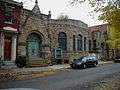
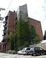 The Mattress Factory art museum at 500 Sampsonia Way. Not in the Mexican War Streets Historic District
 The Mattress Factory's annex gallery building at 1414 Monterey Street (at the corner of Monterey and Jacksonia streets).
References
- "National Register Information System". National Register of Historic Places. National Park Service. March 13, 2009.
- "Mexican War Streets Designated Historic District" (PDF). City of Pittsburgh Historic Review Commission. Archived from the original (PDF) on 2010-01-08. Retrieved 2010-01-06.
- Historic Landmark Plaques 1968-2009 (PDF). Pittsburgh, PA: Pittsburgh History & Landmarks Foundation. 2010. p. 14. Retrieved 2010-07-10.
- Rooney, Dan; Peterson, Carol (2013). Allegheny City: A History of Pittsburgh's North Side. University of Pittsburgh Press. pp. 32–33. ISBN 978-0-8229-4422-5.
- Fleming, George T. (9 July 1916). "Mexican Names for Local Streets". The Gazette Times. Pittsburgh. sec. 5, p. 2.
External links
| Wikimedia Commons has media related to Mexican War Streets. |
| Topics | |
|---|---|
| Lists by state |
|
| Lists by insular areas | |
| Lists by associated state | |
| Other areas | |
| Related | |
| |