Fineview (Pittsburgh)
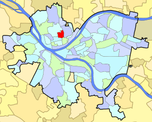
Fineview is a neighborhood on Pittsburgh, Pennsylvania's North Side. It has zip codes of both 15212 and 15214, and has representation on Pittsburgh City Council by the council member for District 6 (North Shore and Downtown neighborhoods) and District 1 (North Central neighborhoods). Fineview was known to older generations as Nunnery Hill. Its modern name derives from the expansive views of downtown Pittsburgh. The most famous of these views is from the Fineview Overlook at the corner of Catoma and Meadville streets.
Fineview | |
|---|---|
 | |
| Coordinates: 40.464°N 80.003°W | |
| Country | United States |
| State | Pennsylvania |
| County | Allegheny County |
| City | Pittsburgh |
| Area | |
| • Total | 0.25 sq mi (0.6 km2) |
| Population (2010)[1] | |
| • Total | 1,285 |
| • Density | 5,100/sq mi (2,000/km2) |
For older generations, this neighborhood was well known for its locally famous streetcar line (#21 Fineview), and for its incline, known as the Nunnery Hill Incline. This incline was one of two in the city that had a curve in it (the other was the Knoxville Incline on the South Side). The incline started at the present-day intersection of Henderson Street and Federal Street. The curve was located in the area of Henderson Street and Jay Street. The incline ended at the top of the hill, along Meadville Street. The old retaining wall that was built for the incline can still be seen running up the side of Henderson Street. This route ran from 1908 to April 30, 1966.
Surrounding neighborhoods
Fineview has four borders with the Pittsburgh neighborhoods of Perry South to the north and west, Central Northside to the southwest, East Allegheny to the south and Spring Hill–City View to the east.
Gallery
 Pittsburgh Skyline on July 28, 2010 from the Fineview Overlook
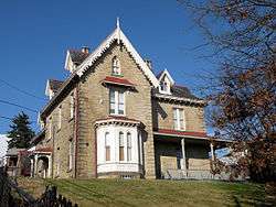 Henderson-Metz House, built circa 1860, at 1516 Warren Street.
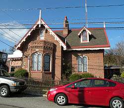 Heathside Cottage, built circa 1855 to 1860, at 416 Catoma Street.
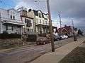 Houses located opposite the Fineview Overlook.
 Fineview (center, with large apartment block) as seen from Frank Curto Park. Troy Hill and Spring Hill can be seen to the right of the neighborhood.
See also
References
- "PGHSNAP 2010 Raw Census Data by Neighborhood". Pittsburgh Department of City Planning [PGHSNAP Utility]. 2012. Retrieved 24 June 2013.
Further reading
- Toker, Franklin (1994) [1986]. Pittsburgh: An Urban Portrait. Pittsburgh: University of Pittsburgh Press. ISBN 0-8229-5434-6.
External links
- Interactive Pittsburgh Neighborhoods Map
