Martel, Lot
Martel is a commune in the Lot department in southwestern France. It is a small medieval town in a region well known for its walnuts and truffles.
Martel | |
|---|---|
 The covered market in Martel | |
.svg.png) Coat of arms | |
Location of Martel 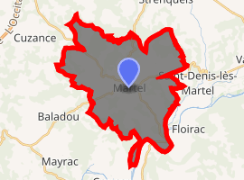
| |
 Martel  Martel | |
| Coordinates: 44°56′16″N 1°36′35″E | |
| Country | France |
| Region | Occitanie |
| Department | Lot |
| Arrondissement | Gourdon |
| Canton | Martel |
| Intercommunality | Communauté de communes Causses et Vallée de la Dordogne |
| Government | |
| • Mayor (2008–2014) | Jean-Claude Requier |
| Area 1 | 35.28 km2 (13.62 sq mi) |
| Population (2017-01-01)[1] | 1,597 |
| • Density | 45/km2 (120/sq mi) |
| Time zone | UTC+01:00 (CET) |
| • Summer (DST) | UTC+02:00 (CEST) |
| INSEE/Postal code | 46185 /46600 |
| Elevation | 92–336 m (302–1,102 ft) (avg. 240 m or 790 ft) |
| 1 French Land Register data, which excludes lakes, ponds, glaciers > 1 km2 (0.386 sq mi or 247 acres) and river estuaries. | |
History
The name of the town means "hammer", and three of these are to be seen on the town's coat of arms. Charles Martel, who earned the nickname "hammer" after his victory in the Battle of Tours in 732,[2] is said to have founded the town.[3] Henry the Young King died here in 1183. In 1219, the town received its charter and was a fiefdom of the Viscounts of Turenne.[3]
Geography
Martel is located about 15 km (9 mi) east of Souillac and 15 km (9 mi) north of the River Dordogne. To the north lies the commune of Cazillac, to the northeast Strenquels, to the east Saint-Denis-lès-Martel, to the southeast Floirac, to the south Montvalent, to the southwest Creysse, to the west Baladou and to the northwest Cuzance.[4]
The countryside is rural with rolling hills, pastureland and the cultivation of walnuts. North of the town lies the elevated limestone plateau of Causse de Martel, much of which is covered with oak and beech woodland.[3]
The town
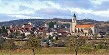
Martel is a medieval town, with the older houses built of pale stone that contrasts with their reddish-brown roofs. The ramparts that used to surround the town are gone but in their place is a wide boulevard and the narrow-streeted central part is a pedestrian area. The town has a distinctive sky-line with medieval towers projecting above the houses, and because of these, the town is sometimes called La ville aux sept tours. The highest tower is that of the Church of Saint-Maur.[5]
There is an eighteenth-century market hall taking up most of the central cobbled square. Markets are held here on Wednesdays and Saturdays, and during late December or January there is an annual truffle market.
In July, the Foire à la Laine (Wool Fair) is held underneath the market hall, with competitions for the best fleeces.[5] There is a museum containing items from Puy d'Issolud, a local Gallic archaeological site which has been identified as Uxellodunum, besieged by Julius Caesar in 51 BC.[6]
See also
References
- "Populations légales 2017". INSEE. Retrieved 6 January 2020.
- "Battle of Tours (732 A.D.)". The Latin Library. Retrieved 2 November 2015.
- Facaros, Dana; Pauls, Michael (2007). Cadogan Guide Dordogne, the Lot & Bordeaux. New Holland Publishers. pp. 151–152. ISBN 978-1-86011-354-3.
- Philips' Modern School Atlas. George Philip and Son, Ltd. 1973. p. 43. ISBN 0-540-05278-7.
- Dodd, Jan (2013). The Rough Guide to Dordogne & the Lot. Rough Guides Limited. pp. 241–. ISBN 978-1-4093-2992-3.
- Rickard, J. (26 March 2009). "Siege of Uxellodunum, Spring-Summer 51 B.C." Retrieved 2 November 2015.
External links
![]()
| Authority control |
|
|---|