Marlborough Township, Montgomery County, Pennsylvania
Marlborough Township is a township in Montgomery County, Pennsylvania, United States. The population was 3,178 at the 2010 census.
Marlborough Township | |
|---|---|
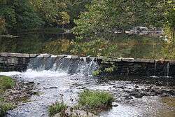 Unami Creek at Swamp Creek Road | |
 Location of Marlborough Township in Montgomery County | |
| Coordinates: 40°23′00″N 75°25′59″W | |
| Country | United States |
| State | Pennsylvania |
| County | Montgomery |
| Area | |
| • Total | 12.38 sq mi (32.1 km2) |
| • Land | 12.21 sq mi (31.6 km2) |
| • Water | 0.17 sq mi (0.4 km2) |
| Elevation | 643 ft (196 m) |
| Population (2010) | |
| • Total | 3,178 |
| • Estimate (2016)[2] | 3,324 |
| • Density | 260/sq mi (99/km2) |
| Time zone | UTC-5 (EST) |
| • Summer (DST) | UTC-4 (EDT) |
| ZIP codes | 18054, 18073, 18074, 18084 |
| Area code(s) | 215, 267, and 445 |
| FIPS code | 42-091-47592 |
| Website | sites |
| Historical population | |||
|---|---|---|---|
| Census | Pop. | %± | |
| 1930 | 966 | — | |
| 1940 | 1,138 | 17.8% | |
| 1950 | 1,432 | 25.8% | |
| 1960 | 1,875 | 30.9% | |
| 1970 | 2,465 | 31.5% | |
| 1980 | 2,849 | 15.6% | |
| 1990 | 3,116 | 9.4% | |
| 2000 | 3,104 | −0.4% | |
| 2010 | 3,178 | 2.4% | |
| Est. 2016 | 3,324 | [2] | 4.6% |
| [3] | |||
It is part of the Upper Perkiomen School District.
History
The Bauern Freund Print Shop, Andreas Rieth Homestead, Sutch Road Bridge in Marlborough Township, and Swamp Creek Road Bridge are listed on the National Register of Historic Places.[4]
Geography
According to the United States Census Bureau, the township has a total area of 12.7 square miles (32.9 km2), of which, 12.5 square miles (32.5 km2) of it is land and 0.2 square miles (0.4 km2) of it (1.34%) is water. It is drained by the Perkiomen Creek into the Schuylkill River and consists mainly of rolling hills and valleys.
The township has a hot-summer humid continental climate (Dfa) and is in hardiness zones 6b and 7a. Average temperatures at the municipal building on Upper Ridge Road range from 29.7 °F in January to 74.3 °F in July.
Its villages include Hoppenville, Perkiomenville (also in Upper Frederick,) and Sumneytown. Its numbered routes are 29 and 63, which has its NW terminus on north-to-south 29 in Green Lane. Other local roads of note include Finland Road, Geryville Pike, Hoppenville Road, Knight Road, Swamp Creek Road, and Upper Ridge Road.
Adjacent municipalities
- Upper Hanover Township (northwest)
- Upper Frederick Township (southwest)
- Green Lane (west)
- Lower Frederick Township (tangent to the south)
- Upper Salford Township (south)
- Salford Township (southeast)
- West Rockhill Township, Bucks County (east)
- Milford Township, Bucks County (northeast)
Demographics
As of the 2010 census, the township was 97.4% White, 1.0% Black or African American, 0.2% Native American, 0.2% Asian, and 1.0% were two or more races. 1.2% of the population were of Hispanic or Latino ancestry.[5]
At the 2000 census there were 3,104 people in 1,174 households, including 888 families, in the township. The population density was 247.6 people per square mile (95.6/km2). There were 1,222 housing units at an average density of 97.5/sq mi (37.7/km2). The racial makeup of the township was 97.55% White, 0.71% African American, 0.13% Native American, 0.16% Asian, 0.64% from other races, and 0.81% from two or more races. Hispanic or Latino of any race were 1.10%.[6]
There were 1,174 households, 32.5% had children under the age of 18 living with them, 67.0% were married couples living together, 6.1% had a female householder with no husband present, and 24.3% were non-families. 19.8% of households were made up of individuals, and 6.9% were one person aged 65 or older. The average household size was 2.63 and the average family size was 3.06.
The age distribution was 23.6% under the age of 18, 6.6% from 18 to 24, 28.1% from 25 to 44, 28.9% from 45 to 64, and 12.8% 65 or older. The median age was 40 years. For every 100 females there were 99.0 males. For every 100 females age 18 and over, there were 98.3 males.
The median household income was $60,170 and the median family income was $68,750. Males had a median income of $47,188 versus $31,667 for females. The per capita income for the township was $26,273. About 0.8% of families and 2.3% of the population were below the poverty line, including 0.7% of those under age 18 and 5.3% of those age 65 or over.
Government and politics
| Year | Republican | Democratic |
|---|---|---|
| 2012 | 56.6% 945 | 41.6% 694 |
| 2008 | 50.3% 838 | 48.5% 809 |
| 2004 | 53.2% 838 | 45.8% 721 |
| 2000 | 53.8% 655 | 40.9% 498 |
| 1996 | 46.0% 516 | 37.8% 424 |
| 1992 | 39.5% 492 | 34.5% 430 |
Marlborough Township has a Township Manager and a 3-person Board of Supervisors.
References
- "2016 U.S. Gazetteer Files". United States Census Bureau. Retrieved Aug 14, 2017.
- "Population and Housing Unit Estimates". Retrieved June 9, 2017.
- "Archived copy". Archived from the original on 2019-04-09. Retrieved 2014-03-21.CS1 maint: archived copy as title (link)
- "National Register Information System". National Register of Historic Places. National Park Service. July 9, 2010.
- https://www.usatoday.com/news/nation/census/profile/PA
- "U.S. Census website". United States Census Bureau. Retrieved 2008-01-31.