East Norriton Township, Montgomery County, Pennsylvania
East Norriton Township is a township and a census-designated place in Montgomery County, Pennsylvania, United States. The population was 13,590 at the 2010 census. It is served by the Norristown Area School District.
East Norriton Township | |
|---|---|
 | |
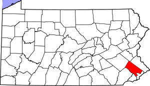
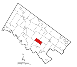 Location of East Norriton Township within Montgomery County, Pennsylvania | |
| Coordinates: 40°09′00″N 75°19′46″W | |
| Country | United States |
| State | Pennsylvania |
| County | Montgomery |
| Area | |
| • Total | 6.06 sq mi (15.71 km2) |
| • Land | 6.05 sq mi (15.68 km2) |
| • Water | 0.01 sq mi (0.03 km2) |
| Elevation | 194 ft (59 m) |
| Population (2010) | |
| • Total | 13,590 |
| • Estimate (2016)[2] | 14,080 |
| • Density | 2,326.12/sq mi (898.14/km2) |
| Time zone | UTC-5 (EST) |
| • Summer (DST) | UTC-4 (EDT) |
| Area code(s) | 610 |
| FIPS code | 42-091-21600 |
| Website | www |
History
The Barley Sheaf Inn and Old Norriton Presbyterian Church are listed on the National Register of Historic Places.[3]
Geography
East Norriton Township is located at 40°8′55″N 75°19′58″W (40.148744, -75.33291).[4]
According to the United States Census Bureau, the township has a total area of 6.1 square miles (16 km2), of which, 6.1 square miles (16 km2) of it is land and 0.16% is water. East Norriton was recognized by Business Week as one of the nation's top five Best Affordable Suburbs in 2009.[5] East Norriton is a former farming community 8 miles (13 km) northwest of Philadelphia's city limits, consisting of residential, commercial, and industrial areas. Shopping malls close to East Norriton are the Plymouth Meeting Mall, which is the closest one at 4 miles (6.4 km) away, and King of Prussia. The township is situated on the US 202 corridor, north of King of Prussia and Norristown.[5] East Norriton has a little league program.
Government and politics
| Year | Republican | Democratic |
|---|---|---|
| 2012 | 44.4% 3,322 | 54.3% 4,068 |
| 2008 | 42.4% 3,173 | 56.8% 4,248 |
| 2004 | 47.6% 3,282 | 52.0% 3,584 |
| 2000 | 45.9% 2,726 | 51.2% 3,038 |
| 1996 | 44.3% 2,405 | 45.6% 2,477 |
| 1992 | 44.0% 2,682 | 37.4% 2,281 |
East Norriton Township is a second-class township that elects five supervisors at-large.
- Kevin McDevitt, Chairman
- Amanda Cappelletti, Vice-chair
- Dennis DeSanto, Jr.
- Ashley DiPiero
- Joseph Gavanus
Demographics
| Historical population | |||
|---|---|---|---|
| Census | Pop. | %± | |
| 1930 | 1,624 | — | |
| 1940 | 1,948 | 20.0% | |
| 1950 | 2,987 | 53.3% | |
| 1960 | 7,773 | 160.2% | |
| 1970 | 11,837 | 52.3% | |
| 1980 | 12,711 | 7.4% | |
| 1990 | 13,324 | 4.8% | |
| 2000 | 13,211 | −0.8% | |
| 2010 | 13,590 | 2.9% | |
| Est. 2016 | 14,080 | [2] | 3.6% |
| [6] | |||
As of the 2010 census, the township was 82.0% White, 9.0% Black or African American, 0.1% Native American, 6.3% Asian, and 1.5% were two or more races. 3.2% of the population were of Hispanic or Latino ancestry.[7]
As of the census[8] of 2000, there were 13,211 people, 5,156 households, and 3,547 families residing in the township. The population density was 2,172.7 people per square mile (838.9/km2). There were 5,310 housing units at an average density of 873.3/sq mi (337.2/km2). The racial makeup of the township was 88.79% White, 6.06% African American, 0.13% Native American, 3.84% Asian, 0.39% from other races, and 0.80% from two or more races. Hispanic or Latino of any race were 1.17% of the population.
There were 5,156 households, out of which 24.7% had children under the age of 18 living with them, 58.4% were married couples living together, 7.2% had a female householder with no husband present, and 31.2% were non-families. 25.4% of all households were made up of individuals, and 11.2% had someone living alone who was 65 years of age or older. The average household size was 2.45 and the average family size was 2.97.
In the township the population was spread out, with 18.8% under the age of 18, 6.1% from 18 to 24, 29.2% from 25 to 44, 25.4% from 45 to 64, and 20.4% who were 65 years of age or older. The median age was 42 years. For every 100 females there were 90.8 males. For every 100 females age 18 and over, there were 88.1 males.
The median income for a household in the township was $60,536, and the median income for a family was $70,162. Males had a median income of $49,737 versus $33,642 for females. The per capita income for the township was $28,749. About 1.9% of families and 2.9% of the population were below the poverty line, including 2.1% of those under age 18 and 5.9% of those age 65 or over.
Economy
Genuardi's, a division of Safeway Inc., formerly had its headquarters in the township.[9][10]
Education
It is in the Norristown Area School District.
Holy Rosary Regional Catholic School in Plymouth Meeting and Plymouth Township is the area Catholic school. It was formed in 2012 by the merger of Our Lady of Victory in East Norriton, Epiphany of Our Lord School in Plymouth Meeting, and St. Titus in East Norriton.[11][12]
References
- "2016 U.S. Gazetteer Files". United States Census Bureau. Retrieved Aug 14, 2017.
- "Population and Housing Unit Estimates". Retrieved June 9, 2017.
- "National Register Information System". National Register of Historic Places. National Park Service. July 9, 2010.
- "US Gazetteer files: 2010, 2000, and 1990". United States Census Bureau. 2011-02-12. Retrieved 2011-04-23.
- https://finance.yahoo.com/real-estate/article/106608/Best-Affordable-Suburbs-2009
- http://www.dvrpc.org/data/databull/rdb/db82/appedixa.xls.
- https://www.usatoday.com/news/nation/census/profile/PA
- "U.S. Census website". United States Census Bureau. Retrieved 2008-01-31.
- "Genuardi's Family Markets L.P." Goliath. Retrieved on December 23, 2009.
- "Zoning Map." East Norriton Township, Pennsylvania. Retrieved on December 23, 2009.
- "2012 Catholic grade school consolidations/closings". Catholicphilly.com. 2012-07-15. Retrieved 2020-04-22.
- "St. Titus". Roman Catholic Archdiocese of Philadelphia. 1998-01-13. Retrieved 2020-05-02.
3006 Keenwood Rd. 19403
- Compare with the East Norriton zoning map for proof of location: "Zoning Map" (PDF). East Norriton Township. Retrieved 2020-05-02.
External links
| Wikivoyage has a travel guide for Pennsylvania. |