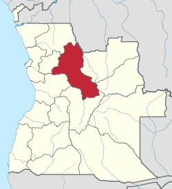
Malanje Province
Malanje is a province of Angola. It has an area of 97,602 km² and a 2014 census population of 986,363.[1] Malanje is the capital of the province.
Malanje | |
|---|---|
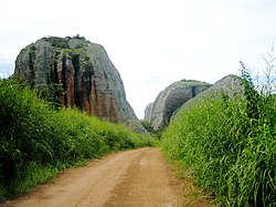 The Black Rocks of Pungo Andongo | |
 Malanje, province of Angola | |
| Country | Angola |
| Capital | Malanje |
| Government | |
| • Governor | Norberto Fernandes dos Santos |
| • Vice-Governor for the Political, Economic and Social Sector | Domingos Manuel Eduardo |
| • Vice-Governor for Technical Services and Infrastructures | Gabriel Domingos António Pontes |
| Area | |
| • Total | 97,602 km2 (37,684 sq mi) |
| Population (2014 census)[1] | |
| • Total | 986,363 |
| • Density | 10/km2 (26/sq mi) |
| ISO 3166 code | AO-MAL |
| HDI (2018) | 0.555[2] medium · 7th |
| Website | www |
Geography
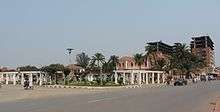
The Malanje Province is located in the north of Angola, the provincial capital and largest town of Malanje located 383 kilometres (238 mi) by road east of the national capital of Luanda.[3] It is bordered to the northwest by Uige Province, to the northeast by the Democratic Republic of the Congo, to the east by Lunda Norte Province and Lunda Sul Province, to the south by Bié Province and Cuanza Sul Province, and in the west by Cuanza Norte Province. The extreme north of the province is covered with savannah, while the southern part is largely dry savannah. The main rivers are the Cuanza River in the southwest and Kwango River in the northeast, and there is a mountainous area known as the Malanje Plateau.[4] The Cuije River and Cuanza flow in the vicinity of Cangandala National Park.[5] Large areas north and southeast of the city of Malanje have been declared protected areas. Of note is the Milando Reserve Park (Reserva Especial do Milando) in the north and the Reserva Natural Integral do Luando at the headwaters of Cuanza.[3]
Municipalities
Malanje Province is divided into 14 municipalities that are further divided into 66 communes (comunas). Municipalities in this province include Cacuso, kalandula, Cambundi-Catembo, Cangandala, Caombo, kiwaba Nzogi, kunda-dia-Bazi, Luquembo, Malanje, Marimba, Massango, Mucari, Quela, and Quirima.[6]
Economy

The province is predominantly agricultural. The most intensively used area in the province of Malanje is the area around the provincial capital, where cotton and sugarcane are the most important industries. The cotton industry was once of vital importance to the national economy, but the years of the Angola Civil War have badly stagnated it. Agriculture in Malanje Province is gradually taking off again, and numerous international investors have been involved, including US$30 million from Brazil to develop the maize and sugarcane industry in the Pungo Andongo area.[7] Malanje Province is also a producer of cassava, sweet potatoes, peanuts, rice, soybeans, sunflowers and various vegetables. The province also has significant reserves of diamonds, limestone, manganese (with 4,682 metric tons exported in 1973),[8] uranium and phosphate.
Tourism has become more important, largely due to its diverse natural attractions, including the Kalandula Falls, the black rock formation of Pungo Andongo, two nature reserves and the Cangandala National Park. Cangandala National Park, the smallest national park in the country,[5] was originally established under Portuguese rule in 1963 to protect the Giant Sable Antelope, before being declared a national park on 25 June 1970.
List of Governors of Malanje
| Name | Years in office |
|---|---|
| Eusébio Sebastião * | (2) 1977–1978 |
| Domingos Afonso Neto * | (3) 1978–1980 |
| Col. Ludy Kissassunda * | (3) 1980–1986 |
| Lt.Col. João Ernesto dos Santos Liberdade * | (7) 1986–1992 |
| João Filipe Martins | (1) 1992 |
| João Manuel Bernardo | (2) 1992–1993 |
| Flávio João Fernandes | (10) 1993–2002 |
| Cristóvão Domingos Francisco da Cunha | (2) 2002–2008 |
| Norberto Fernandes dos Santos Kwata Kwanawa | (8) 2012– |
- Up to 1991, the official name was Provincial Commissioner
References
- "Resultados Definitivos Recenseamento Geral da População e Habitação - 2014" (PDF). Instituto Nacional de Estatística, República de Angola. Retrieved 3 May 2020.
- "Sub-national HDI - Area Database - Global Data Lab". hdi.globaldatalab.org. Retrieved 13 September 2018.
- Google (22 September 2014). "Malanje Province" (Map). Google Maps. Google. Retrieved 22 September 2014.
- Goetz, Philip W..; Sutton, Margaret (1983). The New Encyclopædia Britannica. Encyclopædia Britannica. p. 892. ISBN 978-0-85229-400-0.
- James, W. Martin (5 May 2011). Historical Dictionary of Angola. Scarecrow Press. p. 51. ISBN 978-0-8108-7458-9.
- "Angola". Geohive. Archived from the original on 30 September 2016. Retrieved 22 September 2014.
- Stead, Mike; Rorison, Sean (2013). Angola. Bradt Travel Guides. p. 295. ISBN 978-1-84162-443-3.
- Africa South of the Sahara 2004. Psychology Press. 2003. p. 52. ISBN 978-1-85743-183-4.
- "Histórico dos Governadores" (in Portuguese). malanje.gov.ao. Retrieved 6 March 2019.
External links
| Wikimedia Commons has media related to Malanje Province. |
- Official website of province governor
- Information on this province at the Angolan ministry for territorial administration
- Information on this province at Info Angola
- British website (Angola.uk.org) on Malanje province
- Province geographical info at geoview.info