Maine State Route 150
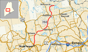
State Route 150 (SR 150) is part of Maine's system of numbered state highways, located in Somerset and Piscataquis counties. Its southern terminus is in Skowhegan at the intersection with U.S. Route 2 (US 2). The northern terminus of the route is at a dead end in Willimantic near Sebec Lake.[2]
| ||||
|---|---|---|---|---|
 | ||||
| Route information | ||||
| Maintained by MaineDOT | ||||
| Length | 50.65 mi[1] (81.51 km) | |||
| Existed | 1925–present | |||
| Major junctions | ||||
| South end | ||||
| North end | Dead end in Willimantic | |||
| Location | ||||
| Counties | Somerset, Piscataquis | |||
| Highway system | ||||
| ||||

Junction list
| County | Location | mi[1] | km | Destinations | Notes |
|---|---|---|---|---|---|
| Somerset | Skowhegan | 0.00 | 0.00 | Southern terminus of SR 150 | |
| Cornville | 10.00 | 16.09 | Southern end of SR 43 concurrency | ||
| Athens | 11.93– 11.95 | 19.20– 19.23 | Northern end of SR 43 concurrency; southern end of SR 151 concurrency | ||
| 12.21 | 19.65 | Northern end of SR 151 concurrency | |||
| Harmony | 20.17 | 32.46 | |||
| Cambridge | 24.96 | 40.17 | Northern terminus of SR 152 | ||
| Piscataquis | Guilford | 36.73 | 59.11 | Southern end of SR 6/SR 15/SR 16 concurrency | |
| 37.10 | 59.71 | Northern end of SR 6/SR 15/SR 16 concurrency | |||
| Willimantic | 50.65 | 81.51 | Dead end | ||
1.000 mi = 1.609 km; 1.000 km = 0.621 mi
| |||||
References
- Maine DOT Map Viewer (Map). Maine Office of GIS. Retrieved October 14, 2017.
- Google (October 14, 2017). "Maine State Route 150" (Map). Google Maps. Google. Retrieved October 14, 2017.
External links
This article is issued from Wikipedia. The text is licensed under Creative Commons - Attribution - Sharealike. Additional terms may apply for the media files.