Mahé district
Mahé district (also spelled Mahe District, French: District de Mahé) is one of the four districts of the Union Territory of Puducherry in India. It consists of the whole of the Mahé region.[1] Mahé is the smallest district of India by size.[2] The total area of Mahé District is surrounded by North Malabar of Kerala State. Three sides by Kannur District and one side by Kozhikode District. Geographically Mahé District is part of North Malabar.
Mahé District | |
|---|---|
District of Puducherry | |
 | |
 Mahé District Location in India  Mahé District Mahé District (India) | |
| Coordinates: 11°42′N 75°32′E | |
| Country | |
| State | Puducherry |
| District | Mahé |
| Population (2011) | |
| • Total | 41,816 |
| Languages | |
| • Official | [[Malayalam]], English |
| • Additional/Cultural | French |
| Time zone | UTC+5:30 (IST) |
| Vehicle registration | PY-03 |

It is the sixth least populous district in the country (out of 731).[3]
Taluks
- Mahé
- Cherukallayi
- Palloor
- Pandakkal
Demographics

According to the 2011 census Mahé district has a population of 41,816,[3] roughly equal to the nation of Liechtenstein.[6] This gives it a ranking of 635th in India (out of a total of 640).[3] The district has a population density of 4,659 inhabitants per square kilometre (12,070/sq mi).[3] Its population growth rate over the decade 2001-2011 was 13.86%.[3] Mahé has a sex ratio of 1,176 females for every 1,000 males,[3] and a literacy rate of 98.35%.[3]
Religion
Religion in Mahe district(2011)
Hinduism is the majority religion in Mahe district. Muslims form a significant minority.
Sri Puthalam Bhagavathy Temple in Mahe is an ancient historic temple of Bhagavathi. The legend of the temple relates the events that occurred during the conflict between the French and Indian armies.[7] There is a historic St Theresa Church in Mahe district; it was constructed by the Christian missionary Ignatius A.S. Hippolytes on 1757 as a part of Mahe Mission.[8]
Tourism
Mooppenkunnu (Hillock)
The Mooppenkunnu is a Hillock. It is a Heritage picnic spot in Mahe district. There are pavements to walk, benches to rest and a restroom facility for the tourists. The hillock contains the historic Light House and is a famous sunset view point.[9]
Walkway
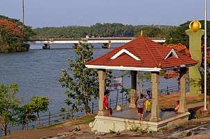
The walkway on the banks of Mahé River is a major tourist attraction. The walkway surrounds around the landscape of the Mahe town. The Walkway has park benches to relax and enjoy the beauty of Mahe River.[10]
Azhimukham
Azhimukham is the estuary of Mahé River and the Arabian Sea. There is a small Tagore Park situated here. Recently there has been a reconstruction which added a 2 km walkway along the bank of river from the estuary towards Mahe Bridge.[11]
See also
- Mahé (disambiguation)
- Karaikal district
- Yanam district
- Puducherry district
- North Malabar
Notes
| Wikimedia Commons has media related to Mahe district. |
- Mahe District official website
- title = District census 2011
- "District Census 2011". Census2011.co.in. 2011. Retrieved 30 September 2011.
- http://mahe.gov.in/
- Srivastava, Dayawanti et al. (ed.) (2010). "States and Union Territories: Pondicherry: Government". India 2010: A Reference Annual (54th ed.). New Delhi, India: Additional Director General, Publications Division, Ministry of Information and Broadcasting (India), Government of India. p. 1222. ISBN 978-81-230-1617-7.CS1 maint: extra text: authors list (link)
- US Directorate of Intelligence. "Country Comparison:Population". Retrieved 1 October 2011.
212 Liechtenstein 35,236 July 2011 est.
- https://mahe.gov.in/tourist-place/tp-puthalam-temple/
- https://mahe.gov.in/tourist-place/tp-st-theresa-shrine/
- https://mahe.gov.in/tourist-place/tp-hillock/
- https://mahe.gov.in/tourist-place/tp-walkway/
- https://mahe.gov.in/tourist-place/tp-azhimukham/
Places adjacent to Mahé district | ||||||||||
|---|---|---|---|---|---|---|---|---|---|---|
| ||||||||||
Capital: Pondicherry | |||||
| Districts | |||||
| Municipalities | |||||
| Languages | |||||
| Education | |||||
| History |
| ||||
| Places of interest | |||||
| Transport |
| ||||
| Sports |
| ||||