Lunglei district
Lunglei district is one of the eleven districts of Mizoram state in India. As of 2011 it is the second most populous district in the state, after Aizawl.[1] It is also the largest district in Mizoram with an area of 4,572 km2(1,765 sq mi).
Lunglei district | |
|---|---|
District of Mizoram | |
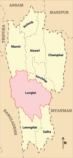 Location of Lunglei district in Mizoram | |
| Country | India |
| State | Mizoram |
| Headquarters | Lunglei |
| Government | |
| • Lok Sabha constituencies | Mizoram |
| • Vidhan Sabha constituencies | 7 |
| Area | |
| • Total | 4,536 km2 (1,751 sq mi) |
| Population (2001) | |
| • Total | 161,428 |
| • Density | 36/km2 (92/sq mi) |
| Demographics | |
| • Literacy | 88.86 |
| • Sex ratio | 947 |
| Time zone | UTC+05:30 (IST) |
| Website | lunglei |
Toponymy
The district is named after its headquarters, Lunglei. Lunglei, sometimes spelled Lungleh, in Mizo means a bridge of rock. It derived its name from a bridge like rock found in the riverine area around the Nghasih, a small tributary of the river Tlawng.
Geography
The district is bounded on the north by Mamit and Aizawl districts, on the west by Bangladesh, on the south by Lawngtlai district, on the southeast by Saiha district, on the east by Myanmar and on the northeast by Serchhip District. The district occupies an area of 4538 km². Lunglei town is the administrative headquarters of the district.
Divisions
The district has 2 Subdivision Lunglei and Tlabung. The district has 7 assembly constituencies. These are South Tuipui, Lunglei North, Lunglei East, Lunglei West, Lunglei South, Thorang and West Tuipui.
Demographics
According to the 2011 census Lunglei district has a population of 161,428, roughly equal to the nation of Saint Lucia.[2] This gives it a ranking of 597th in India (out of a total of 640). The district has a population density of 36 inhabitants per square kilometre (93/sq mi). Its population growth rate over the decade 2001-2011 was 17.64%. Lunglei has a sex ratio of 947 females for every 1000 males, and a literacy rate of 88.86%.[3]
| Historical population | ||
|---|---|---|
| Year | Pop. | ±% p.a. |
| 1971 | 60,403 | — |
| 1981 | 86,511 | +3.66% |
| 1991 | 111,415 | +2.56% |
| 2001 | 137,223 | +2.11% |
| 2011 | 161,428 | +1.64% |
| source:[4] | ||
References
- "District Census 2011". Census2011.co.in. 2011. Retrieved 30 September 2011.
- US Directorate of Intelligence. "Country Comparison:Population". Retrieved 1 October 2011.
Saint Lucia 161,557 July 2011 est.
- census2011. "Lunglei District : Census 2011 data". census2011.co.in. Retrieved 15 June 2013.
- Decadal Variation In Population Since 1901
External links
- Official site
- "Base Map of Lunglei District, Mizoram". Agriculture - Remote Sensing and GIS. Department of Agriculture, Government of Mizoram. Archived from the original on 26 August 2015.
- "Drainage Map of Lunglei District, Showing Coding up to Mico Watershed, Mizoram". Agriculture - Remote Sensing and GIS. Department of Agriculture, Government of Mizoram. Archived from the original on 26 August 2015.
Places adjacent to Lunglei district | |
|---|---|
| State symbols | |
|---|---|
| Government |
|
| Topics | |
| Districts | |
| Urban Areas | |
| Infrastructure |
|
| Education |
|
| Tourism | |
| Protected areas | |
| Mizo Culture | |