Hmuifang
Hmuifang is a tourist spot near Aizawl, Mizoram. It is about 50 km from Aizawl. With an elevation of 1619 metres[1] the mountain is still covered with virgin forests reserved since all the Mizo Chief's time.[2]
| Hmuifang | |
|---|---|
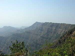 Hmuifang Mountainside | |
| Highest point | |
| Elevation | 1,619 m (5,312 ft) |
| Prominence | 1,619 m (5,312 ft) |
| Geography | |
| Location | Aizawl District, Mizoram, India |
| Parent range | Lushai Hills |
| Geology | |
| Age of rock | around 10th BC |
| Mountain type | volcanic eruption |
History
Hmuifang Tourist resort has been built right on the former land of Lallianvunga the erstwhile chief who used to rule over the villages in the mountain.[3] Hmuifang is also the source of Tuirial River.
Thalfavang Kut
Thalfavang Kut, a Mizo festival is being regularly being held in Hmuifang organized the Tourism Department of Mizoram to promote Tourism.[4] Different Mizo dances like Cheraw, Sawlakai, Siktuithiang lam and Chheihlam[5] are showcased in the festival.[6]
References
- "Mountain in Mizoram". mizoram nic in. Retrieved 29 November 2018.
- "HMUIFANG TOURIST RESORT". Govt of Mizoram. Retrieved 24 August 2012.
- Patawrawt. "Hmuifang tlang ah lawn ru". misual.com. Retrieved 24 August 2012.
- "V Purushothaman Keen to Build Mizoram Tourist Destination". Northeast Today. Archived from the original on 18 February 2013. Retrieved 24 August 2012.
- "Thalfavang Kut hawn a ni". Ralvengtu. Retrieved 24 August 2012.
- "GOVERNOR IN THALFAVANG KUT A HMANPUI". DIPR Mizoram. Retrieved 24 August 2012.
External links
| State symbols | |
|---|---|
| Government |
|
| Topics | |
| Districts | |
| Urban Areas | |
| Infrastructure |
|
| Education |
|
| Tourism | |
| Protected areas | |
| Mizo Culture | |
This article is issued from Wikipedia. The text is licensed under Creative Commons - Attribution - Sharealike. Additional terms may apply for the media files.