Lukla
Lukla (Nepali: लुक्ला) is a small town in the Khumbu Pasanglhamu rural municipality of the Solukhumbu District in the Province No. 1 of north-eastern Nepal. Situated at 2,860 metres (9,383 ft), it is a popular place for visitors to the Himalayas near Mount Everest to arrive. Although Lukla means place with many goats and sheep, few are found in the area nowadays.
Lukla | |
|---|---|
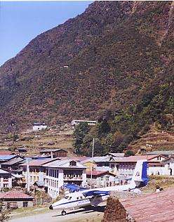 Looking across the township of Lukla, with the air strip of Lukla Airport in the foreground | |
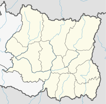 Lukla Location in Nepal  Lukla Lukla (Nepal) | |
| Coordinates: 27°41′20″N 86°43′50″E | |
| Country | |
| Province | Province No. 1 |
| District | Solukhumbu District |
| Rural municipality | Khumbu Pasanglhamu |
| Government | |
| • Type | Ward division |
| Elevation | 2,860 m (9,380 ft) |
| Time zone | UTC+5:45 (Nepal Time) |
| Postal code | 56010 |
| Area code(s) | 038 |
Lukla contains a small airport servicing the region, and a variety of shops and lodges catering to tourists and trekkers, providing western-style meals and trail supplies. From Lukla, travellers will take two days to reach the village Namche Bazaar, an altitude acclimatization stop for those continuing on.[1] In August 2014, the Nepalese government announced plans to open the first tarmac road from Kathmandu to Lukla.[2]
Airport

Lukla is served by the Tenzing-Hillary Airport. Weather permitting, twin-engined Dornier Do 228s and de Havilland Canada Twin Otters make frequent daylight flights between Lukla and Kathmandu. Lukla Airport has a very short and steep airstrip, often compounded by hazardous weather, resulting in several fatal accidents. It has been called the most dangerous airport in the world.[4][3]
Climate
Lukla has a subarctic climate (Köppen classification Dwc) with warm summers and very cold winters. There is high diurnal temperature variation, and temperatures can reach freezing even in the middle of summer.
| Climate data for Lukla, Nepal | |||||||||||||
|---|---|---|---|---|---|---|---|---|---|---|---|---|---|
| Month | Jan | Feb | Mar | Apr | May | Jun | Jul | Aug | Sep | Oct | Nov | Dec | Year |
| Average high °C (°F) | 1.0 (33.8) |
1.9 (35.4) |
4.7 (40.5) |
8.2 (46.8) |
11.6 (52.9) |
14.7 (58.5) |
14.4 (57.9) |
13.4 (56.1) |
12.7 (54.9) |
8.9 (48.0) |
5.5 (41.9) |
3.3 (37.9) |
8.4 (47.0) |
| Daily mean °C (°F) | −5.9 (21.4) |
−4.8 (23.4) |
−1.6 (29.1) |
2.2 (36.0) |
5.6 (42.1) |
9.2 (48.6) |
10.3 (50.5) |
9.8 (49.6) |
8.0 (46.4) |
3.1 (37.6) |
−1.2 (29.8) |
−3.8 (25.2) |
2.6 (36.6) |
| Average low °C (°F) | −18.2 (−0.8) |
−16.3 (2.7) |
−12.1 (10.2) |
−7.4 (18.7) |
−3.4 (25.9) |
1.6 (34.9) |
3.9 (39.0) |
3.5 (38.3) |
0.8 (33.4) |
−6.5 (20.3) |
−12.5 (9.5) |
−16.3 (2.7) |
−6.9 (19.6) |
| Average precipitation mm (inches) | 10.8 (0.43) |
18.0 (0.71) |
21.6 (0.85) |
28.3 (1.11) |
34.4 (1.35) |
96.1 (3.78) |
153.8 (6.06) |
144.7 (5.70) |
80.7 (3.18) |
37.4 (1.47) |
6.2 (0.24) |
13.0 (0.51) |
645 (25.39) |
| Average precipitation days | 2.6 | 2.7 | 3.6 | 5.0 | 9.5 | 16.1 | 22 | 21.8 | 15.0 | 4.5 | 1.9 | 1.4 | 106.1 |
| Source: weatherbase.com[5] | |||||||||||||
See also
References
- Muza, SR; Fulco, CS; Cymerman, A (2004). "Altitude Acclimatization Guide". US Army Research Inst. of Environmental Medicine Thermal and Mountain Medicine Division Technical Report (USARIEM–TN–04–05). Retrieved 2009-03-05.
- "A new highway... up to Everest: First tarmac road to town known as gateway to the mountain set to be built". Retrieved 2014-08-14.
- "Which Everest Base Camp is Best:Tibet or Nepal?".
- "World's Most Dangerous Airports". Retrieved 2011-03-25.
- http://www.weatherbase.com/weather/weather.php3?s=603638
External links
| Wikimedia Commons has media related to Lukla. |
- Hiking Everest from Lukla, GoNOMAD feature article
- "The Lukla Airport Experience" article and photos on GearJunkie.com.
- "Most Dangerous airport in the world" Lukla Airport video
- Lukla Travel Guide
- "Lukla Flight Scheduled"