Lockeford, California
Lockeford is an unincorporated community in San Joaquin County, California, United States. For statistical purposes, the United States Census Bureau has defined Lockeford as a census-designated place (CDP). The census definition of the area may not precisely correspond to local understanding of the area with the same name. The population was 3,233 at the 2010 census, up from 3,179 at the 2000 census.
Lockeford | |
|---|---|
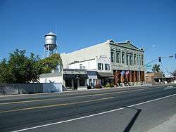 Downtown Lockeford | |
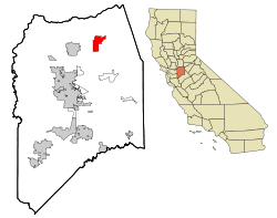 Location in San Joaquin County and the state of California | |
 Lockeford Location in the United States | |
| Coordinates: 38°9′27″N 121°9′5″W | |
| Country | |
| State | |
| County | San Joaquin |
| Government | |
| • Senate | Cathleen Galgiani (D) |
| • Assembly | Heath Flora (R) |
| • U. S. Congress | Jerry McNerney (D)[1] |
| Area | |
| • Total | 8.387 sq mi (21.723 km2) |
| • Land | 8.341 sq mi (21.603 km2) |
| • Water | 0.046 sq mi (0.120 km2) 0.55% |
| Elevation | 102 ft (31 m) |
| Population (2010) | |
| • Total | 3,233 |
| • Density | 390/sq mi (150/km2) |
| Time zone | UTC-8 (PST) |
| • Summer (DST) | UTC-7 (PDT) |
| ZIP code | 95237 |
| Area code(s) | 209 |
| FIPS code | 06-42104 |
| GNIS feature ID | 0277543 |
| Reference no. | 365[3] |
History
Lockeford is registered as California Historical Landmark #365.[3] The town is named after Dean Jewett Locke, who, with his brother Elmer, settled in the area in 1851. Dean Locke then established a ranch and later the town in the region. It was Dean Locke's wife Delia who first coined the name "Lockeford" in 1859, referencing the ford that he built across the Mokelumne River.[3] Delia Locke's diaries chronicled the early history of Lockeford and her family's history in founding the town. They are available at the University of the Pacific.[4]
Geography
Lockeford is located at 38°9′27″N 121°9′5″W (38.157565, -121.151455).[5]
According to the United States Census Bureau, the CDP has a total area of 8.4 square miles (22 km2), 99.45% of it land, and 0.55% of it water.
The town is served by California State Route 88, one of four routes the crosses over the Sierra Nevada in the region.
Demographics
| Historical population | |||
|---|---|---|---|
| Census | Pop. | %± | |
| U.S. Decennial Census[6] | |||
2010
At the 2010 census Lockeford had a population of 3,233. The population density was 385.5 people per square mile (148.8/km²). The racial makeup of Lockeford was 2,526 (78.1%) White, 10 (0.3%) African American, 22 (0.7%) Native American, 64 (2.0%) Asian, 13 (0.4%) Pacific Islander, 413 (12.8%) from other races, and 185 (5.7%) from two or more races. Hispanic or Latino of any race were 956 people (29.6%).[7]
The census reported that 3,217 people (99.5% of the population) lived in households, 16 (0.5%) lived in non-institutionalized group quarters, and no one was institutionalized.
There were 1,142 households, 401 (35.1%) had children under the age of 18 living in them, 650 (56.9%) were opposite-sex married couples living together, 103 (9.0%) had a female householder with no husband present, 73 (6.4%) had a male householder with no wife present. There were 70 (6.1%) unmarried opposite-sex partnerships, and 5 (0.4%) same-sex married couples or partnerships. 257 households (22.5%) were one person and 127 (11.1%) had someone living alone who was 65 or older. The average household size was 2.82. There were 826 families (72.3% of households); the average family size was 3.32.
The age distribution was 829 people (25.6%) under the age of 18, 264 people (8.2%) aged 18 to 24, 743 people (23.0%) aged 25 to 44, 929 people (28.7%) aged 45 to 64, and 468 people (14.5%) who were 65 or older. The median age was 39.2 years. For every 100 females, there were 108.2 males. For every 100 females age 18 and over, there were 101.8 males.
There were 1,221 housing units at an average density of 145.6 per square mile, of the occupied units 862 (75.5%) were owner-occupied and 280 (24.5%) were rented.The homeowner vacancy rate was 2.3%; the rental vacancy rate was 11.1%. 2,278 people (70.5% of the population) lived in owner-occupied housing units and 939 people (29.0%) lived in rental housing units.
2000
At the 2000 census there were 3,179 people, 1,099 households, and 856 families in the CDP. The population density was 379.7 people per square mile (146.6/km²). There were 1,136 housing units at an average density of 135.7 per square mile (52.4/km²). The racial makeup of the CDP was 77.41% White, 0.25% African American, 1.04% Native American, 1.42% Asian, 0.38% Pacific Islander, 16.07% from other races, and 3.43% from two or more races. Hispanic or Latino of any race were 24.66%.[8]
Of the 1,099 households 36.1% had children under the age of 18 living with them, 62.4% were married couples living together, 9.1% had a female householder with no husband present, and 22.1% were non-families. 18.2% of households were one person and 9.6% were one person aged 65 or older. The average household size was 2.89 and the average family size was 3.26.
The age distribution was 27.8% under the age of 18, 8.6% from 18 to 24, 26.9% from 25 to 44, 23.0% from 45 to 64, and 13.7% 65 or older. The median age was 37 years. For every 100 females, there were 105.1 males. For every 100 females age 18 and over, there were 102.4 males.
The median household income was $43,750 and the median family income was $55,750. Males had a median income of $37,759 versus $24,353 for females. The per capita income for the CDP was $19,533. About 10.5% of families and 12.5% of the population were below the poverty line, including 18.5% of those under age 18 and 3.6% of those age 65 or over.
Notable people
- Weldon B. Cooke, Aviation pioneer
References
- "California's 9th Congressional District - Representatives & District Map". Civic Impulse, LLC. Retrieved March 12, 2013.
- U.S. Census Archived 2012-07-02 at the Wayback Machine
- "Lockeford". Office of Historic Preservation, California State Parks. Retrieved 2012-10-14.
- "All Delia Locke Diaries | Delia Locke Diaries | University of the Pacific". scholarlycommons.pacific.edu. Retrieved 2019-10-29.
- "US Gazetteer files: 2010, 2000, and 1990". United States Census Bureau. 2011-02-12. Retrieved 2011-04-23.
- "Census of Population and Housing". Census.gov. Retrieved June 4, 2016.
- "2010 Census Interactive Population Search: CA - Lockeford CDP". U.S. Census Bureau. Archived from the original on July 15, 2014. Retrieved July 12, 2014.
- "U.S. Census website". United States Census Bureau. Retrieved 2008-01-31.
External links
- Diaries of Delia Locke, wife of Lockeford founder Dean Jewett Locke, from 1855-1879 are available online at the University of the Pacific Library Digital Collections.
Municipalities and communities of San Joaquin County, California, United States | ||
|---|---|---|
| Cities | 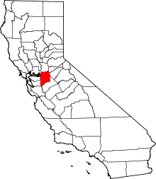 San Joaquin County map | |
| CDPs | ||
| Unincorporated communities | ||
| Ghost towns |
| |