List of waterways forming and crossings of the Atlantic Intracoastal Waterway
This is a list of waterways that form the Atlantic Intracoastal Waterway, sometimes called the Intracoastal Canal, and crossings (bridges, tunnels and ferries) of it.
Florida
- Florida Bay
- Baker Cut (manmade)
- Buttonwood Sound
- Grouper Creek
- Tarpon Basin
- Dusenberg Creek
- Blackwater Sound
- Jewfish Creek
- Barnes Sound
- Little Card Sound
- Card Sound
- Biscayne Bay
- Rickenbacker Causeway (north approach is SR 913)
- Dodge Island Bridge (SR 886)
- MacArthur Causeway (SR A1A)
- Venetian Causeway
- Julia Tuttle Causeway (I-195 (SR 112))
- John F. Kennedy Causeway (SR 934)
- Broad Causeway (SR 922)
- Biscayne Creek
- Sunny Isles Causeway (SR 826)
- Dumfoundling Bay
- Man-made canal
- Stranahan River
- 17th Street Causeway (SR A1A)
- New River
- New River Sound
- SR 842
- Middle River
- Man-made canal
- SR 838
- SR 816
- SR 870
- SR 814
- SR 844
- Hillsboro River
- SR 810 (Hillsboro Blvd.)
- Man-made canal (Hillsboro Canal branches off it)
- Lake Boca Raton
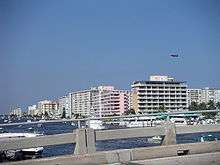 The intracoastal waterway in Pompano Beach, Florida
- Palmetto Park Road (CR 798)
- Man-made canal?
- Lake Wyman
- Lake Rogers
- SR 800
- Man-made canal
- Lake Worth
- Lake Worth Creek
- Loxahatchee River
- Jupiter Sound
- CR 707
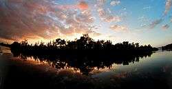
Sunset from the Intracoastal Waterway in Hobe Sound
- Hobe Sound
- Jupiter Narrows
- CR 707
- Peck Lake
- Man-made canal
- Great Pocket
- Indian River
- SR A1A
- Frank A. Wacha Bridge (SR 732)
- South Causeway Bridge (SR A1A)
- North Causeway Bridge (SR A1A)
- 17th Street Causeway (SR 656)
- Merrill P. Barber Bridge (SR 60)
- Wabasso Causeway (SR 510)
- Ernest Kouwen-Hoven Bridge (Melbourne Causeway) (US 192 (SR 500))
- Eau Gallie Bridge (Eau Gallie Causeway) (SR 518)
- Pineda Bridge (Pineda Causeway) (SR 404)
- Hubert H. Humphrey Bridge (Merritt Island Causeway) (SR 520)
- Emory L. Bennett Causeway (SR 528)
- NASA Parkway (SR 405)
- A. Maxwell Brewer Memorial Causeway (CR 402)
- U.S. Government Railroad
- Haulover Canal (manmade)
- Former SR 3
- Indian River North
- Mosquito Lagoon
- Ponce de Leon Cut (manmade)
- Halifax River
- Port Orange Causeway (William V. Chappell Jr. Memorial Bridge or Dunlawton Bridge) (SR A1A)
- Veterans Memorial Bridge (CR 4050)
- Broadway Bridge (US 92 and SR 600)
- Main Street Bridge (CR 4040)
- Seabreeze Bridge (SR 430)
- Granada Bridge (SR 40)
- Halifax Creek
- Smith Creek
- Man-made canal
- Fox Cut (manmade)
- Man-made canal
- Palm Coast Parkway
- Matanzas River
- Tolomato River
- Vilano Beach Bridge (SR A1A)
- Man-made canal
- Tolomato River
- Man-made canal
- Palm Valley Bridge (CR 210)
- Pablo Creek
- SR 202 "Butler Blvd"
- McCormick Bridge (US 90 "Beach Blvd." (SR 212))
- SR 10 "Atlantic Blvd."
- SR 116 "Wonderwood Bridge"
- Sisters Creek
- Gunnison Cut (manmade)
- Sawpit Creek
- Man-made canal
- South Amelia River
- Man-made canal
- Kingsley Creek
- Amelia River
- Cumberland Sound Florida/Georgia state line
Georgia
- Cumberland Sound – USGS Feature Detail Report
- Passenger ferry between St Marys and Cumberland Island
- Cumberland Dividings – USGS Feature Detail Report
- Cumberland River – USGS Feature Detail Report
- St. Andrew Sound – USGS Feature Detail Report
- Jekyll Sound – USGS Feature Detail Report
- Jekyll Creek (Jekyll River) – USGS Feature Detail Report
- Jekyll Island Causeway, M. E. Thompson Bridge
- Brunswick River – USGS Feature Detail Report
- Saint Simons Sound – USGS Feature Detail Report
- Manhead Sound – USGS Feature Detail Report
- Mackay River – USGS Feature Detail Report
- F. J. Torras Causeway
- Buttermilk Sound – USGS Feature Detail Report
- Altamaha Sound – USGS Feature Detail Report
- Little Mud River – USGS Feature Detail Report
- Back River (Georgia) – USGS Feature Detail Report
- North River – USGS Feature Detail Report
- Doboy Sound – USGS Feature Detail Report
- Old Teakettle Creek – USGS Feature Detail Report
- Crescent River – USGS Feature Detail Report
- Creighton Narrows – USGS Feature Detail Report
- Front River – USGS Feature Detail Report
- Sapelo River – USGS Feature Detail Report
- Sapelo Sound – USGS Feature Detail Report
- South Newport River – USGS Feature Detail Report
- Johnson Creek
- North Newport River – USGS Feature Detail Report
- Saint Catherines Sound – USGS Feature Detail Report
- Bear River
- Florida Passage – USGS Feature Detail Report
- Ogeechee River
- Hell Gate – USGS Feature Detail Report
- Ossabaw Sound – USGS Feature Detail Report
- Green Island Sound – USGS Feature Detail Report
- Vernon River – USGS Feature Detail Report
- Moon River
- Skidaway Narrows – USGS Feature Detail Report
- Skidaway River – USGS Feature Detail Report
- Wilmington River – USGS Feature Detail Report
- Saint Augustine Creek – USGS Feature Detail Report
- Elba Island Cut – USGS Feature Detail Report
- South Channel Savannah River – USGS Feature Detail Report
- Savannah River
South Carolina
In South Carolina, the waterway is made of numerous natural and manmade waterways that wind among the sea islands.[1][2][3] The Pine Island cut is the longest manmade section of the entire waterway. It was the last section of the waterway to be completed and was dedicated on April 11, 1936.[4]
- Savannah River
- Fields Cut
- Wright River
- Watts Cut
- New River
- Ramshorn Creek
- Calibogue Sound
- Skull Creek
- Fixed span to Hilton Head Island
- Port Royal Sound
- Beaufort River
- Ladys Island Swing Bridge
- Brickyard Creek
- Coosaw River
- Ashepoo Coosaw Cutoff
- Rock Creek
- Ashepoo Coosaw Cutoff
- Ashepoo River
- Fenwick Cut
- South Edisto River
- Watts Cut
- North Creek
- Dawhoo River
- McKinley Washington, Jr. Bridge (fixed span)
- Wadmalaw River
- Church Flats
- Stono River
- John F. Limehouse Memorial Bridge (fixed span)
- Elliott Cut
- Wappoo Creek
- Wappoo Creek Bridge
 The Wappoo Creek bascule bridge near Charleston, SC.
 - Cooper River (Charleston County, South Carolina)
- Wappoo Creek Bridge
- Charleston Harbor
- Jeanette Creek
- Sullivans Narrows
- Ben Sawyer Bridge (swing span)
- Meeting Reach
- Isle of Palms Connector Bridge (fixed span)
- Seven Reaches
- Copahee Sound
- Capers Creek
- Price Creek
- Seewee Bay
- manmade canal
- Graham Creek
- Awendaw Creek
- Harbor River
- Mathews Cut
- Casino Creek
- Fourmile Creek Canal (crosses South Santee River)
- North Santee River
- Estherville Minim Creek Canal
- South Island Ferry
- Winyah Bay
- Waccamaw River
- L. W. Siau Bridge (fixed span)
- Socastee Creek
- Benjamin Thrailkill Bridge (fixed span)
- Socastee Swing Bridge (Dick Pond Road)[5]
- Pine Island cut (manmade canal, approximately 24 miles long)[6]
- US 501, Black Skimmer Trail (fixed span)
- Pine Island bascule bridge, originally built as a combination rail and vehicle span[7]
- Robert M. Grissom Parkway (fixed span)
- Grande Dunes Boulevard (fixed span)
- S.C. 22 (fixed spans)
- Barefoot Resort Bridge (swing bridge)
- Little River
North Carolina
- manmade canal
- Sunset Boulevard (Sunset Beach)

- Shallotte River
- manmade canal

- Lockwoods Folly River
- manmade canal
- (Future Second Oak Island crossing)


- Cape Fear River
- manmade canal
- Masonboro Sound
- Middle Sound
- Topsail Sound
- Stump Sound
- New River
- White Oak River
- Bogue Sound

- Bay View Road
- Newport River
- manmade canal
- Adams Creek
- Neuse River
- Pamlico Sound
- manmade canal
- Goose Creek
- Pamlico River
- Pungo River
- manmade canal
- Alligator River
- Albemarle Sound
- North River
- Great Swamp
- manmade canal
- Currituck Sound
- North Landing River
Virginia
- North Landing River
- Pungo Ferry Road
- VA 165
- manmade canal
- Centerville Turnpike
- VA 168/Chesapeake Expressway
- South Branch Elizabeth River
- VA 168 Business/Battlefield Boulevard
- US 17/Dominion Boulevard
- High Rise Bridge (I-64/Hampton Roads Beltway)
- Gilmerton Bridge (US 13/US 460/Military Highway)
- Jordan Bridge (VA 337)
- Downtown Tunnel (I-264/US 460 Alternate)
- Elizabeth River
- Hampton Roads
- James River
- Hampton Roads Bridge–Tunnel (I-64/Hampton Roads Beltway)
Maryland
- Chesapeake Bay
- Chesapeake and Delaware Canal
Delaware
- Chesapeake and Delaware Canal
- Delaware Bay
New Jersey
- Cape May Canal
- Route 162
- Route 109
- Middle Thorofare Bridge (CR 621 (Ocean Drive))
- Jarvis Sound
- George Reading Wildwood Bridge (Route 47)
- Grassy Sound
- Route 147
- Grassy Sound Bridge (CR 619 (Ocean Drive))
- Great Channel
- Stone Harbor Bridge (CR 657 (Stone Harbor Blvd))
- Great Sound
- CR 601 (Avalon Blvd)
- Ingrams Thorofare
- Townsend Channel
- Ludlam Thoroughfare
- CR 625 (Sea Isle Blvd)
- Ludlam Bay
- Crook Horn Creek
- 34th Street Bridge (CR 623)
- Peck Bay
- Great Egg Harbor
- Howard S. Stainton Memorial Causeway/Ninth Street Bridge (Route 52)
- Risley Channel
- Lake's Bay
- West Canal
- Inside Thorofare
- Clam Thorofare
- Reed's Bay
- Little Bay
- Great Bay
- Little Egg Harbor
- Manahawkin Bay
- Barnegat Bay
- Point Pleasant Canal
- Manasquan River
New York
- The New York State Canal System is part of the Intracoastal Waterway[9]
- East River
- Long Island Sound
- Bronx-Whitestone Bridge
- Throgs Neck Bridge
Connecticut
- Long Island Sound
- Bridgeport-Port Jefferson Ferry
- Cross Sound Ferry
Rhode Island
Massachusetts
- Buzzards Bay
- Cape Cod Canal
- Cape Cod Bay
- Massachusetts Bay
- Annisquam River
- Blynman Canal Bridge
- Gloucester Railroad Bridge
- Route 128
New Hampshire
- Piscataqua River – mouth forms harbor
References
- Intracoastal Waterway: Beaufort River to St. Simons Sound (Map). 1 : 40,000. Nautical Charts. National Oceanic and Atmospheric Administration, Office of Coast Survey. 2009. 11507. Retrieved 2009-02-08.
- Intracoastal Waterway: Casino Creek to Beaufort River (Map). 1 : 40,000. Nautical Charts. National Oceanic and Atmospheric Administration, Office of Coast Survey. 2009. 11518. Retrieved 2009-02-08.
- Intracoastal Waterway: Myrtle Grove Sound and Cape Fear River to Casino Creek (Map). 1 : 40,000. Nautical Charts. National Oceanic and Atmospheric Administration, Office of Coast Survey. 2009. 11534. Retrieved 2009-02-08.
- Lewis, Catherine Heniford (1998). Horry County, South Carolina, 1730–1993 (Google books). Columbia, South Carolina: University of South Carolina Press. pp. xxiii, 192. ISBN 978-1-57003-207-3. Retrieved 2009-02-08.
- Socastee Swing Bridge Archived 2009-06-16 at the Wayback Machine on HorryCounty.org
- Intracoastal Waterway Archived 2009-06-16 at the Wayback Machine on HorryCounty.org
- House Bill 4430 of the 110th session of the South Carolina General Assembly
- Little River Bridge Archived 2008-10-11 at the Wayback Machine on HorryCounty.org
- http://www.nyscanals.gov/exvac/landwater/index.html Archived 2007-10-25 at the Wayback Machine, 4th paragraph, as of 8-NOV-2007
2. Cruiser Net – http://www.cruisersnet.net/index.php?categoryid=65
See also
- Waterways forming and crossings of the Gulf Intracoastal Waterway
This article is issued from Wikipedia. The text is licensed under Creative Commons - Attribution - Sharealike. Additional terms may apply for the media files.