North Carolina Highway 210
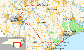
North Carolina Highway 210 (NC 210) is a 192-mile-long (309 km) primary state highway in the U.S. state of North Carolina that connects settlements in the Atlantic Coastal Plain region. Due to its meandering route NC 210 changes directional orientation three times, changing from east-west to north-south at Old Stage Road east of Angier, then changing from north-south to west-east at the Bladen–Pender county line.[1] The route traverses through central Fayetteville and the Fort Bragg Army installation and crosses both Topsail Island access bridges over the Atlantic Intracoastal Waterway.[1] Owing primarily to its meandering route, NC 210 is the sixth longest state highway in North Carolina.
| ||||
|---|---|---|---|---|
 Route of NC 210 highlighted in red | ||||
| Route information | ||||
| Maintained by NCDOT | ||||
| Length | 191.8 mi[1] (308.7 km) | |||
| Existed | 1931–present | |||
| Major junctions | ||||
| From | ||||
| To | ||||
| Location | ||||
| Counties | Onslow, Pender, Bladen, Cumberland, Harnett, Johnston | |||
| Highway system | ||||
| ||||

Route description
Coastal North Carolina (east-west)
NC 210 begins in Onslow County, northwest of the unincorporated community of Sneads Ferry, at US 17. Signed west here, the road actually heads in a southeasterly direction through a commercial district west of Sneads Ferry, crossing NC 172. The route become Island Drive as it crosses a bridge over the Atlantic Intracoastal Waterway and turns southwest along Topsail Island, forming the main road along the narrow barrier island and passing through several resort communities. In Surf City, it merges with NC 50 to cross the Intracoastal Waterway again, traveling northward though Surf City before splitting off to the west. Near the Holly Shelter Game Preserve it merges with US 17 and travels southwest towards the unincorporated community of Hampstead, where it leaves to the west and takes a winding path towards an interchange with I-40 in the Pender County community of Rocky Point. Following a winding path eastwards through several rural, unincorporated communities, it crosses US 421 and has a brief concurrency with NC 53 before turning due north and changing designations from east-west to north-south before entering Bladen County.
Sandhills (north-south)
NC 210 continues as a primarily rural route northbound through Bladen County, turning to the northwest as it enters Sampson County near the unincorporated community of Ivanhoe. After it crosses US 701 south of the town of Garland it passes to the east of Bladen Lakes State Forest and continues northeast towards Fayetteville, merging with NC 53 just outside of the unincorporated community of Judson. Upon entering Fayetteville, NC 53 ends, and NC 210 joins with NC 24 to form a concurrency along Grove Street. In Downtown Fayetteville, NC 210 leaves along Murchison Road to the northwest, merges again with NC 24 after crossing the NC 295 freeway, and the two routes continue on northwards into the town of Spring Lake along Bragg Boulevard. At the center of Spring Lake, NC 210 splits off to the northeast and crosses into Harnett County near the community of Anderson Creek. After merging with US 401 in the community of Shawtown, the two routes merge with US 421 to cross the Cape Fear River in Lillington. In the north of Lillington, both US routes leave in opposite directions and NC 210 continues northwards towards Angier. In Angier, the route turns again, this time changing designation to west-east.
Johnston County (west-east)
Continuing into Johnston County heading eastbound, NC 210 forms the primary road through the community of McGee's Crossroads, located between NC 50 and I-40 along NC 210. After leaving the McGee's Crossroads area, the route continues eastbound through a mostly rural area, before reaching its terminus in West Smithfield at US 70 Business.
History
Junction list
| County | Location | mi[1] | km | Destinations | Notes |
|---|---|---|---|---|---|
| Johnston | Smithfield | 0.0 | 0.0 | ||
| McGee's Crossroads | 12.3– 12.5 | 19.8– 20.1 | I-40 Exit 319 | ||
| 13.7 | 22.0 | ||||
| Harnett | | 20.1 | 32.3 | Route transition from westbound to southbound at Old Stage Road | |
| Angier | 23.1 | 37.2 | |||
| Lillington | 30.7 | 49.4 | North end of US 401, south end of US 421 and east end of NC 27 overlaps | ||
| 32.2 | 51.8 | North end of US 421 overlap | |||
| 32.7 | 52.6 | West end of NC 27 overlap | |||
| 32.8 | 52.8 | South end of US 401 overlap | |||
| Cumberland | Spring Lake | 50.8 | 81.8 | West end of NC 24 overlap, north end of NC 87 overlap | |
| 51.5– 52.1 | 82.9– 83.8 | Randolph Street / Butner Road – Pope AAF | Interchange | ||
| | 52.4– 53.3 | 84.3– 85.8 | Honeycutt Road – Simmons AAF | Interchange | |
| | 54.3– 54.9 | 87.4– 88.4 | East end of NC 24 overlap, south end of NC 87 overlap; I-295 exit 23 | ||
| Fayetteville | 56.9 | 91.6 | |||
| 59.9 | 96.4 | West end of NC 24 overlap | |||
| 61.3 | 98.7 | ||||
| 62.0 | 99.8 | East end of NC 24 overlap; west end of NC 53 overlap | |||
| 65.5– 65.7 | 105.4– 105.7 | I-95 exit 49 | |||
| Stedman | 68.7 | 110.6 | East end of NC 53 overlap | ||
| | 86.5 | 139.2 | |||
| Bladen | | 97.3 | 156.6 | ||
| | 102.1 | 164.3 | |||
| | 121.9 | 196.2 | West end of NC 53 overlap | ||
| | 122.6 | 197.3 | East end of NC 53 overlap | ||
| | 125.6 | 202.1 | |||
| Bladen–Pender county line | | 126.2 | 203.1 | Route transition from southbound to eastbound at county line | |
| Pender | Currie | 137.2 | 220.8 | ||
| Rocky Point | 143.3 | 230.6 | |||
| 148.2 | 238.5 | ||||
| 148.5– 148.6 | 239.0– 239.1 | I-40 exit 408 | |||
| Hampstead | 161.8 | 260.4 | South end of US 17 overlap | ||
| Surf City | 170.5 | 274.4 | North end of US 17 overlap | ||
| 173.3 | 278.9 | North end of NC 50 overlap | |||
| 175.3– 175.4 | 282.1– 282.3 | South end of NC 50 overlap; roundabout | |||
| Onslow | Sneads Ferry | 187.7 | 302.1 | ||
| Dixon | 191.8 | 308.7 | |||
1.000 mi = 1.609 km; 1.000 km = 0.621 mi
| |||||
See also
- North Carolina Bicycle Route 3 - Concurrent with NC 210 from Island Creek Road near Hampstead to Shaw Highway near Rocky Point
- North Carolina Bicycle Route 5 - Concurrent with NC 210 from Blueberry Road in Currie to Morgan Road in Still Bluff and again on its concurrency with NC 53
References
- Google (November 23, 2017). "North Carolina Highway 210" (Map). Google Maps. Google. Retrieved November 23, 2017.
External links

- NCRoads.com: N.C. 210